File:Capela de Nossa Senhora da Conceição do Engenho Poxim 2017-8563.jpg
![File:Capela de Nossa Senhora da Conceição do Engenho Poxim 2017-8563.jpg](https://upload.wikimedia.org/wikipedia/commons/thumb/9/9e/Capela_de_Nossa_Senhora_da_Concei%C3%A7%C3%A3o_do_Engenho_Poxim_2017-8563.jpg/800px-Capela_de_Nossa_Senhora_da_Concei%C3%A7%C3%A3o_do_Engenho_Poxim_2017-8563.jpg?20201005001026)
Original file (4,933 × 3,289 pixels, file size: 11.82 MB, MIME type: image/jpeg)
Captions
Captions
Summary
[edit]DescriptionCapela de Nossa Senhora da Conceição do Engenho Poxim 2017-8563.jpg |
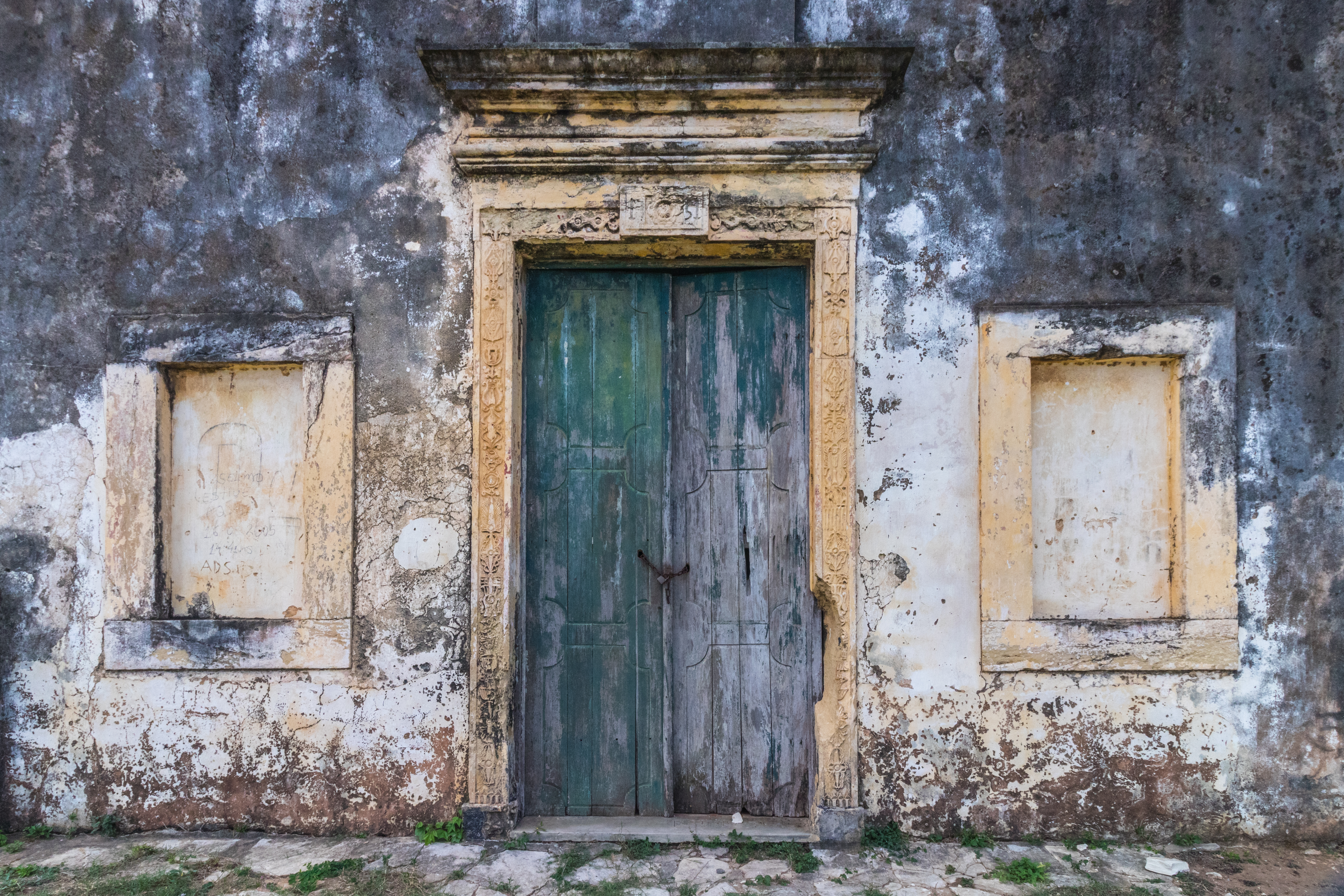
English: The Chapel of Our Lady of the Conception of Engenho Poxim (Portuguese: Capela de Nossa Senhora da Conceição do Engenho Poxim) is an 18th-century Roman Catholic church in São Cristóvão, Sergipe, Brazil. It was built as part of the Engenho Poxim sugarcane plantation, which existed along the Poxim Açu River, a small branch of the Poxim River, in the southwest of the municipality of São Cristóvão. The church is located in a remote, rural setting in the present-day Rosa Luxemburgo II settlement. It was listed as a historic structure by National Institute of Historic and Artistic Heritage (IPHAN) in 1943. It church has fallen into a state of neglect and lacks the interior elements present at the time of its survey and federal historical designation. (Source: Wikipedia) Português: A Capela de Nossa Senhora da Conceição do Engenho Poxim é uma igreja católica apostólica romana do século XVIII em São Cristóvão, Sergipe. Foi construída como parte da fazenda de cana Engenho Poxim, que existia ao longo do rio Poxim Açu, um pequeno afluente do rio Poxim, no sudoeste do município de São Cristóvão. A igreja está localizada em um ambiente rural remoto no atual assentamento Rosa Luxemburgo II. Foi tombado como estrutura histórica pelo Instituto Nacional do Patrimônio Histórico e Artístico (IPHAN) em 1943. A igreja está abandonada e carece dos elementos interiores presentes no momento do tombamento. (Fonte: Wikipedia.)
|
|||||||||||||||||||
Date | ||||||||||||||||||||
Source | Own work | |||||||||||||||||||
Author |
creator QS:P170,Q57979330 |
Camera location | 10° 53′ 29.72″ S, 37° 14′ 15.69″ W ![]() ![]() | View this and other nearby images on: OpenStreetMap | ![]() |
---|
Licensing
[edit]![w:en:Creative Commons](https://upload.wikimedia.org/wikipedia/commons/thumb/7/79/CC_some_rights_reserved.svg/90px-CC_some_rights_reserved.svg.png)
![attribution](https://upload.wikimedia.org/wikipedia/commons/thumb/1/11/Cc-by_new_white.svg/24px-Cc-by_new_white.svg.png)
![share alike](https://upload.wikimedia.org/wikipedia/commons/thumb/d/df/Cc-sa_white.svg/24px-Cc-sa_white.svg.png)
- You are free:
- to share – to copy, distribute and transmit the work
- to remix – to adapt the work
- Under the following conditions:
- attribution – You must give appropriate credit, provide a link to the license, and indicate if changes were made. You may do so in any reasonable manner, but not in any way that suggests the licensor endorses you or your use.
- share alike – If you remix, transform, or build upon the material, you must distribute your contributions under the same or compatible license as the original.
![]() |
This image was uploaded as part of Wiki Loves Monuments 2020.
Afrikaans ∙ Alemannisch ∙ azərbaycanca ∙ Bahasa Indonesia ∙ Bahasa Melayu ∙ Bikol Central ∙ bosanski ∙ brezhoneg ∙ català ∙ čeština ∙ Cymraeg ∙ dansk ∙ davvisámegiella ∙ Deutsch ∙ eesti ∙ English ∙ español ∙ Esperanto ∙ euskara ∙ français ∙ Frysk ∙ Gaeilge ∙ galego ∙ hrvatski ∙ Ido ∙ italiano ∙ latviešu ∙ Lëtzebuergesch ∙ Malagasy ∙ magyar ∙ Malti ∙ Nederlands ∙ norsk ∙ norsk nynorsk ∙ norsk bokmål ∙ polski ∙ português ∙ português do Brasil ∙ română ∙ shqip ∙ sicilianu ∙ slovenčina ∙ slovenščina ∙ suomi ∙ svenska ∙ Tagalog ∙ Türkçe ∙ Yorùbá ∙ Zazaki ∙ Ελληνικά ∙ беларуская ∙ беларуская (тарашкевіца) ∙ български ∙ кыргызча ∙ македонски ∙ русский ∙ српски / srpski ∙ українська ∙ ქართული ∙ հայերեն ∙ नेपाली ∙ हिन्दी ∙ বাংলা ∙ മലയാളം ∙ ไทย ∙ 한국어 ∙ +/− |
![]() |
![]() |
This image was awarded with the 10th prize in the national contest of Brazil in Wiki Loves Monuments 2020 Other languages:
العربية | беларуская (тарашкевіца) | বাংলা | Deutsch | English | British English | español | français | hrvatski | italiano | ქართული | македонски | norsk (bokmål) | norsk (nynorsk) | português do Brasil | русский | slovenščina | svenska | українська | +/− |
![]() |
This image has been assessed using the Quality image guidelines and is considered a Quality image.
العربية ∙ جازايرية ∙ беларуская ∙ беларуская (тарашкевіца) ∙ български ∙ বাংলা ∙ català ∙ čeština ∙ Cymraeg ∙ Deutsch ∙ Schweizer Hochdeutsch ∙ Zazaki ∙ Ελληνικά ∙ English ∙ Esperanto ∙ español ∙ eesti ∙ euskara ∙ فارسی ∙ suomi ∙ français ∙ galego ∙ עברית ∙ हिन्दी ∙ hrvatski ∙ magyar ∙ հայերեն ∙ Bahasa Indonesia ∙ italiano ∙ 日本語 ∙ Jawa ∙ ქართული ∙ 한국어 ∙ kurdî ∙ Lëtzebuergesch ∙ lietuvių ∙ македонски ∙ മലയാളം ∙ मराठी ∙ Bahasa Melayu ∙ Nederlands ∙ Norfuk / Pitkern ∙ polski ∙ português ∙ português do Brasil ∙ rumantsch ∙ română ∙ русский ∙ sicilianu ∙ slovenčina ∙ slovenščina ∙ shqip ∙ српски / srpski ∙ svenska ∙ தமிழ் ∙ తెలుగు ∙ ไทย ∙ Tagalog ∙ Türkçe ∙ toki pona ∙ українська ∙ vèneto ∙ Tiếng Việt ∙ 中文 ∙ 中文(简体) ∙ 中文(繁體) ∙ +/− |
File history
Click on a date/time to view the file as it appeared at that time.
Date/Time | Thumbnail | Dimensions | User | Comment | |
---|---|---|---|---|---|
current | 00:10, 5 October 2020 | ![]() | 4,933 × 3,289 (11.82 MB) | Prburley (talk | contribs) | pattypan 20.04 |
You cannot overwrite this file.
File usage on Commons
The following 7 pages use this file:
- Wiki Loves Monuments 2020 winners
- User talk:Prburley
- Commons:Esplanada/Arquivo11
- Commons:Quality images/Subject/Architecture/Close-ups/Archive 2021
- Commons:Quality images candidates/Archives October 05 2021
- Category:Capela de Nossa Senhora da Conceição do Engenho Poxim
- Category:Interior of Capela de Nossa Senhora da Conceição do Engenho Poxim
File usage on other wikis
The following other wikis use this file:
- Usage on outreach.wikimedia.org
- Usage on pt.wikipedia.org
- Usage on www.wikidata.org
Metadata
This file contains additional information such as Exif metadata which may have been added by the digital camera, scanner, or software program used to create or digitize it. If the file has been modified from its original state, some details such as the timestamp may not fully reflect those of the original file. The timestamp is only as accurate as the clock in the camera, and it may be completely wrong.
Camera manufacturer | Canon |
---|---|
Camera model | Canon EOS Rebel T6s |
Author | Paul R. Burley |
Exposure time | 1/250 sec (0.004) |
F-number | f/11 |
ISO speed rating | 400 |
Date and time of data generation | 09:50, 14 March 2017 |
Lens focal length | 10 mm |
Latitude | 10° 53′ 29.72″ S |
Longitude | 37° 14′ 15.69″ W |
Altitude | 70.8 meters above sea level |
Label | Red |
Horizontal resolution | 240 dpi |
Vertical resolution | 240 dpi |
Software used | Adobe Photoshop Lightroom Classic 9.0 (Windows) |
File change date and time | 08:15, 14 February 2020 |
Exposure Program | Aperture priority |
Exif version | 2.31 |
Date and time of digitizing | 09:50, 14 March 2017 |
APEX shutter speed | 7.965784 |
APEX aperture | 6.918863 |
APEX exposure bias | −0.66666666666667 |
Maximum land aperture | 4.375 APEX (f/4.56) |
Metering mode | Pattern |
Flash | Flash did not fire |
DateTimeOriginal subseconds | 98 |
DateTimeDigitized subseconds | 98 |
Color space | sRGB |
Focal plane X resolution | 6,718.9249720045 |
Focal plane Y resolution | 6,734.0067340067 |
Focal plane resolution unit | inches |
Custom image processing | Normal process |
Exposure mode | Auto bracket |
White balance | Manual white balance |
Scene capture type | Standard |
GPS time (atomic clock) | 14:48 |
Satellites used for measurement | 12 |
Receiver status | Measurement in progress |
Measurement mode | 3-dimensional measurement |
Measurement precision | Fair (1.9) |
Reference for direction of image | Magnetic direction |
Direction of image | 31 |
Geodetic survey data used | WGS-84 |
GPS date | 14 March 2017 |
GPS tag version | 0.0.3.2 |
Serial number of camera | 052032010085 |
Lens used | EF-S10-18mm f/4.5-5.6 IS STM |
Date metadata was last modified | 02:15, 14 February 2020 |
Unique ID of original document | F979D2E3F34184FFE56BB2633B5E2FEC |
Copyright status | Copyright status not set |
Keywords | brazil 2017 march |
IIM version | 4 |
Structured data
Items portrayed in this file
depicts
14 March 2017
10°53'29.724"S, 37°14'15.691"W
0.004 second
11
10 millimetre
400
image/jpeg
8e3941c4b7ac5e2171f46e6f44f3d38fc1c998f4
12,396,904 byte
3,289 pixel
4,933 pixel
- Pages with unresolved properties
- Cultural heritage monuments in Brazil with known IDs
- CC-BY-SA-4.0
- Self-published work
- Images from Wiki Loves Monuments 2020
- Images from Wiki Loves Monuments 2020 in Brazil
- Images from Wiki Loves Monuments missing SDC creator
- Winners of Wiki Loves Monuments 2020 in Brazil
- Nominated pictures for Wiki Loves Monuments International
- Brazil photographs taken on 2019-09-29
- Brazil images by Paul R. Burley
- Images from Wiki Loves Monuments 2020 in Brazil - Sergipe
- Uploaded with pattypan
- Images from Wiki Loves Monuments 2020 in Brazil - Third Round
- Images from Wiki Loves Monuments 2020 in Brazil - Second Round
- Quality images of Brazil
- Quality images from Wiki Loves Monuments Brazil 2020
- Quality images
- Quality images missing SDC creator
- Pages with maps