File:Canudos-map.jpg
Jump to navigation
Jump to search
No higher resolution available.
Canudos-map.jpg (353 × 467 pixels, file size: 21 KB, MIME type: image/jpeg)
Captions
Captions
Add a one-line explanation of what this file represents
Summary
[edit]
|
This map image could be re-created using vector graphics as an SVG file. This has several advantages; see Commons:Media for cleanup for more information. If an SVG form of this image is available, please upload it and afterwards replace this template with
{{vector version available|new image name}}.
It is recommended to name the SVG file “Canudos-map.svg”—then the template Vector version available (or Vva) does not need the new image name parameter. |


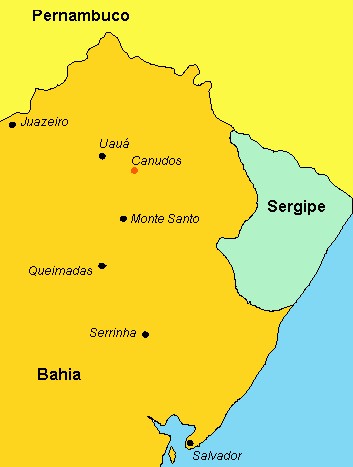
| Description | A political map of Northeast en:Brazil, showing the location of en:Canudos in the northern tip of the state of en:Bahia, an insurrected settlement under the leadership of mystic en:Antonio Conselheiro, destroyed during the en:War of Canudos (en:1896-en:1897. Illustration by en:Renato M.E. Sabbatini, PhD, 2005, who hereby grants en:GFDL rights to Wikipedia. |
| Date | 20 August 2005 (original upload date) |
| Source | Transferred from en.wikipedia to Commons. |
| Author | The original uploader was Rsabbatini at English Wikipedia. |
License information.
[edit]
| This file is licensed under the Creative Commons Attribution-Share Alike 3.0 Unported license. Subject to disclaimers. | ||
| ||
| This licensing tag was added to this file as part of the GFDL licensing update. |

|
Permission is granted to copy, distribute and/or modify this document under the terms of the GNU Free Documentation License, Version 1.2 or any later version published by the Free Software Foundation; with no Invariant Sections, no Front-Cover Texts, and no Back-Cover Texts. A copy of the license is included in the section entitled GNU Free Documentation License. Subject to disclaimers. |
Original upload log
[edit]
The original description page was here. All following user names refer to en.wikipedia.
- 2005-08-20 21:39 Rsabbatini 353×467×8 (21860 bytes) A political map of Northeast [[Brazil]], showing the location of [[Canudos]] in the northern tip of the state of [[Bahia]], an insurrected settlement under the leadership of mystic [[Antonio Conselheiro]], destroyed during the [[War of Canudos]] ([[1896]]
File history
Click on a date/time to view the file as it appeared at that time.
| Date/Time | Thumbnail | Dimensions | User | Comment | |
|---|---|---|---|---|---|
| current | 16:08, 4 September 2007 | | 353 × 467 (21 KB) | Liftarn (talk | contribs) | {{SVG|map}} {{Information |Description=A political map of Northeast en:Brazil, showing the location of en:Canudos in the northern tip of the state of en:Bahia, an insurrected settlement under the leadership of mystic [[:en:Antonio Conselhe |
You cannot overwrite this file.
File usage on Commons
The following page uses this file:
File usage on other wikis
The following other wikis use this file:
- Usage on az.wikipedia.org
- Usage on ca.wikipedia.org
- Usage on en.wikipedia.org
- Usage on es.wikipedia.org
- Usage on fr.wikipedia.org
- Usage on ga.wikipedia.org
- Usage on he.wikipedia.org
- Usage on pt.wikipedia.org
- Usage on pt.wikibooks.org
- Usage on sh.wikipedia.org
- Usage on tr.wikipedia.org
- Usage on www.wikidata.org