File:Cannon Brewery, Rutland Road, Neepsend, Sheffield - 5 - geograph.org.uk - 1778484.jpg
Jump to navigation
Jump to search

Size of this preview: 800 × 600 pixels. Other resolutions: 320 × 240 pixels | 640 × 480 pixels | 1,024 × 768 pixels | 1,280 × 960 pixels | 2,576 × 1,932 pixels.
Original file (2,576 × 1,932 pixels, file size: 1.03 MB, MIME type: image/jpeg)
Captions
Captions
Add a one-line explanation of what this file represents
Summary
[edit]
| Description |
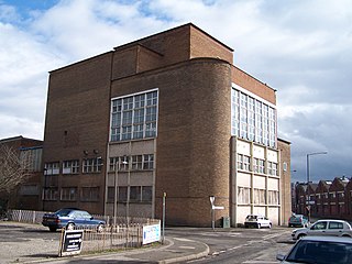
English: Cannon Brewery, Rutland Road, Neepsend, Sheffield - 5. The 1905 OS map shows that a school was originally on the corner, and some research indicates that it closed in 1946, when the Neepsend area was designated for Industry as opposed to Residential! I bet the former headmasters will be spinning in their graves! For more views of the brewery and area see ... 1778394 1778422 1778440 1778464 1778479 For a different view of this building and a 'close up' of the detail see ... 1802989 1803000 |
| Date | |
| Source | From geograph.org.uk |
| Author | Terry Robinson |
| Attribution (required by the license) | Terry Robinson / Cannon Brewery, Rutland Road, Neepsend, Sheffield - 5 / |
| Camera location | | View this and other nearby images on: OpenStreetMap |
|---|
_heading:90.00&language=en)
| Object location | | View this and other nearby images on: OpenStreetMap |
|---|
_heading:90.00&language=en)
Licensing
[edit]

|
This image was taken from the Geograph project collection. See this photograph's page on the Geograph website for the photographer's contact details. The copyright on this image is owned by Terry Robinson and is licensed for reuse under the Creative Commons Attribution-ShareAlike 2.0 license.
|
This file is licensed under the Creative Commons Attribution-Share Alike 2.0 Generic license.
Attribution: Terry Robinson
- You are free:
- to share – to copy, distribute and transmit the work
- to remix – to adapt the work
- Under the following conditions:
- attribution – You must give appropriate credit, provide a link to the license, and indicate if changes were made. You may do so in any reasonable manner, but not in any way that suggests the licensor endorses you or your use.
- share alike – If you remix, transform, or build upon the material, you must distribute your contributions under the same or compatible license as the original.
File history
Click on a date/time to view the file as it appeared at that time.
| Date/Time | Thumbnail | Dimensions | User | Comment | |
|---|---|---|---|---|---|
| current | 22:40, 11 March 2011 | | 2,576 × 1,932 (1.03 MB) | GeographBot (talk | contribs) | == {{int:filedesc}} == {{Information |description={{en|1=Cannon Brewery, Rutland Road, Neepsend, Sheffield - 5 That rounded corner looks like 1970s to me. The 1905 OS map shows that a school was originally on the corner, and some research indicates that i |
You cannot overwrite this file.
File usage on Commons
There are no pages that use this file.