File:Canary Islands (11653511925).jpg

Original file (2,312 × 1,992 pixels, file size: 785 KB, MIME type: image/jpeg)
Captions
Captions
Summary
[edit].jpg&action=edit§ion=1)
| Description |
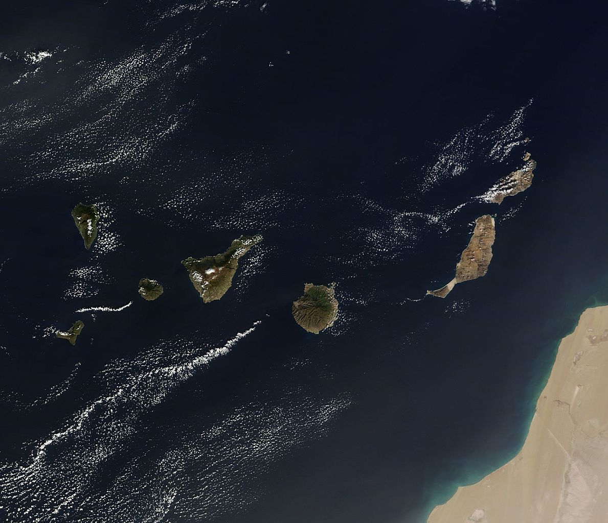
On December 10, 2013 the Moderate Resolution Imaging Spectroradiometer (MODIS) aboard NASA’s Terra satellite flew across the central Atlantic Ocean and captured a true-color image of the Canary Islands. Lying off of the coast of Western Sahara and Morocco, the islands were created by successive submarine volcanic eruptions which raised the ocean floor vertically until some of land rose above sea level. The oldest islands lie in the east and the youngest in the west. From east to west, the major islands seen in this image are: Lanzarote, Fuerteventura, Gran Canaria, Tenerife, La Gomera, La Palmera and El Hierro. While the creation of the islands began in the Late Cretaceous Period (70 – 80 million years ago), active volcanic activity continues. In 2011, a spectacular submarine eruption occurred just off the shore of El Hierro. The volcano became quiet again, but very recently increasing earthquakes and changing height of El Hierro suggested the volcano may again be entering an active eruptive phase. On December 27 the island’s volcano monitoring agency had raised the volcanic eruption risk for El Hierro to “yellow” – a code that means increasing activity but no eruption imminent. That afternoon a magnitude 5.1 earthquake struck offshore at El Hierro. The epicenter was 9 miles (15 km) deep, and it was one of the largest quakes ever recorded at the island. Credit: NASA/GSFC/Jeff Schmaltz/MODIS Land Rapid Response Team NASA Goddard Space Flight Center enables NASA’s mission through four scientific endeavors: Earth Science, Heliophysics, Solar System Exploration, and Astrophysics. Goddard plays a leading role in NASA’s accomplishments by contributing compelling scientific knowledge to advance the Agency’s mission. Follow us on Twitter Like us on Facebook Find us on Instagram |
| Date | |
| Source | Canary Islands |
| Author | NASA Goddard Space Flight Center from Greenbelt, MD, USA |
Licensing
[edit].jpg&action=edit§ion=2)
- You are free:
- to share – to copy, distribute and transmit the work
- to remix – to adapt the work
- Under the following conditions:
- attribution – You must give appropriate credit, provide a link to the license, and indicate if changes were made. You may do so in any reasonable manner, but not in any way that suggests the licensor endorses you or your use.
| This image was originally posted to Flickr by NASA Goddard Photo and Video at https://flickr.com/photos/24662369@N07/11653511925. It was reviewed on 17 September 2016 by FlickreviewR and was confirmed to be licensed under the terms of the cc-by-2.0. |
| This file is in the public domain in the United States because it was solely created by NASA. NASA copyright policy states that "NASA material is not protected by copyright unless noted". (See Template:PD-USGov, NASA copyright policy page or JPL Image Use Policy.) | ||
 |
Warnings:
|
File history
Click on a date/time to view the file as it appeared at that time.
| Date/Time | Thumbnail | Dimensions | User | Comment | |
|---|---|---|---|---|---|
| current | 20:50, 17 September 2016 | | 2,312 × 1,992 (785 KB) | Vanished Account Byeznhpyxeuztibuo (talk | contribs) | Transferred from Flickr via Flickr2Commons |
You cannot overwrite this file.
File usage on Commons
There are no pages that use this file.
File usage on other wikis
The following other wikis use this file:
- Usage on gu.wikipedia.org
.jpg&oldid=847250584)