File:Canal pour les eaux de pluies.jpg
Jump to navigation
Jump to search

Size of this preview: 800 × 450 pixels. Other resolutions: 320 × 180 pixels | 640 × 360 pixels | 1,024 × 576 pixels | 1,280 × 720 pixels | 3,072 × 1,728 pixels.
Original file (3,072 × 1,728 pixels, file size: 1.96 MB, MIME type: image/jpeg)
Captions
Captions
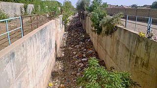
A very deep channel for rainwater
Summary
[edit]
| Description |
Français : Il est très rare de trouver un canal si profond dans la ville de Thiès, ce canal passe au milieu de la base militaire de Thiès, et ensuite vers la forêt. D'habitude ce canal conduit les eaux de pluies vers la forêt, mais ce qu'on a noté récemment il y'en a des personnes qui s'y jettent des ordures et cela peut entraîner des dégâts grave sur l'environnement.
English: It is very rare to find a channel so deep in the city of Thiès, this channel passes in the middle of the military base of Thiès, and then towards the forest. Usually this channel leads rainwater to the forest, but what we have noticed recently there are people who throw garbage there and this can cause serious damage to the environment
中文:Votre texte a été corrigé.
在 Thiès á 市如此深的地方,很难找到一条通道,这条通道在 Thiès á 军事基地的中间,然后向森林走。 通常这条通道会将雨水引向森林,但最近人们注意到,人们向森林扔垃圾,这可能对环境造成严重破坏
Español: Es muy raro encontrar un canal tan profundo en la ciudad de Thiès, este canal pasa a través de la base militar de Thiès, y luego al bosque. Por lo general, este canal lleva el agua de lluvia al bosque, pero lo que se ha observado recientemente es que hay gente que tira basura en el bosque, lo que puede ocasionar graves daños al medio ambiente.
Ab: Es ist sehr selten, einen so tiefen Kanal in der Stadt Thies zu finden, dieser Kanal verläuft mitten auf der Militärbasis von Thies und dann in den Wald. Normalerweise leitet dieser Kanal das Regenwasser in den Wald, aber was wir in letzter Zeit festgestellt haben, ist, daß es Menschen gibt, die Müll in den Wald werfen, und das kann zu schweren Umweltschäden führen.
|
||
| Date | |||
| Source | Own work | ||
| Author | Babacar Dioum |
| Camera location | | View this and other nearby images on: OpenStreetMap |
|---|
Licensing
[edit]
I, the copyright holder of this work, hereby publish it under the following license:
This file is licensed under the Creative Commons Attribution-Share Alike 4.0 International license.
- You are free:
- to share – to copy, distribute and transmit the work
- to remix – to adapt the work
- Under the following conditions:
- attribution – You must give appropriate credit, provide a link to the license, and indicate if changes were made. You may do so in any reasonable manner, but not in any way that suggests the licensor endorses you or your use.
- share alike – If you remix, transform, or build upon the material, you must distribute your contributions under the same or compatible license as the original.

|
This image was uploaded as part of Wiki Loves Africa 2020 photographic contest.
|
File history
Click on a date/time to view the file as it appeared at that time.
| Date/Time | Thumbnail | Dimensions | User | Comment | |
|---|---|---|---|---|---|
| current | 16:21, 9 April 2020 | | 3,072 × 1,728 (1.96 MB) | Babacar Dioum (talk | contribs) | Uploaded own work with UploadWizard |
You cannot overwrite this file.
File usage on Commons
There are no pages that use this file.
File usage on other wikis
The following other wikis use this file:
- Usage on fr.wikipedia.org