File:Canal Basin, Chester.jpg
From Wikimedia Commons, the free media repository
Jump to navigation
Jump to search
Size of this preview: 800 × 528 pixels. Other resolutions: 320 × 211 pixels | 640 × 422 pixels | 1,024 × 675 pixels | 1,280 × 844 pixels | 2,560 × 1,688 pixels | 6,870 × 4,530 pixels.
Original file (6,870 × 4,530 pixels, file size: 4.6 MB, MIME type: image/jpeg)
File information
Structured data
Captions
Summary
[edit]DescriptionCanal Basin, Chester.jpg |
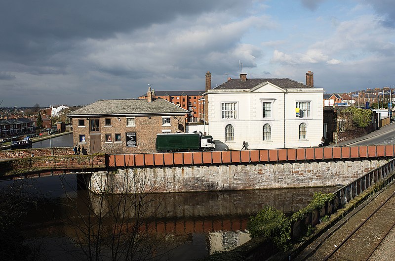
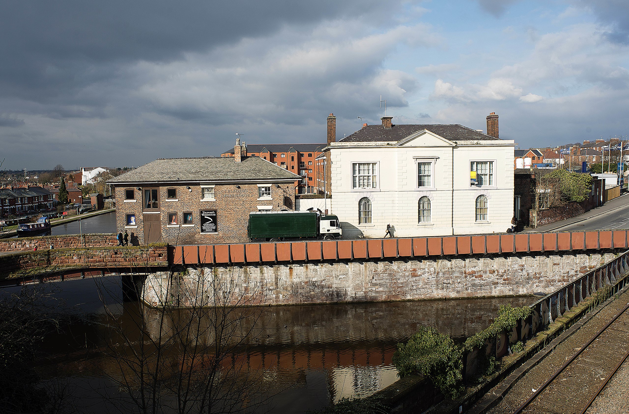
English: Photograph of the Canal Basin, Chester |
Date | |
Source | https://www.geograph.org.uk/photo/3342474 |
Author | Brian Fox |
Attribution (required by the license) InfoField | Brian Fox / Canal basin. Tower Wharf Chester / |
InfoField | Brian Fox / Canal basin. Tower Wharf Chester |
Camera location | 53° 11′ 35.92″ N, 2° 53′ 54.24″ W | View this and other nearby images on: OpenStreetMap | 53.193310; -2.898400 |
---|
This is a photo of listed building number 1375918. |
This is a photo of listed building number 1375919. |
Wikidata has entry Diocesan House (Q26656622) with data related to this item. |
Wikidata has entry Telford's Warehouse (Q7697201) with data related to this item. |
Licensing
[edit]This image was taken from the Geograph project collection. See this photograph's page on the Geograph website for the photographer's contact details. The copyright on this image is owned by Brian Fox and is licensed for reuse under the Creative Commons Attribution-ShareAlike 2.0 license.
|
This file is licensed under the Creative Commons Attribution-Share Alike 2.0 Generic license.
Attribution: Brian Fox
- You are free:
- to share – to copy, distribute and transmit the work
- to remix – to adapt the work
- Under the following conditions:
- attribution – You must give appropriate credit, provide a link to the license, and indicate if changes were made. You may do so in any reasonable manner, but not in any way that suggests the licensor endorses you or your use.
- share alike – If you remix, transform, or build upon the material, you must distribute your contributions under the same or compatible license as the original.
File history
Click on a date/time to view the file as it appeared at that time.
Date/Time | Thumbnail | Dimensions | User | Comment | |
---|---|---|---|---|---|
current | 23:34, 16 September 2017 | 6,870 × 4,530 (4.6 MB) | Geograph Update Bot (talk | contribs) | Higher-resolution version from Geograph. | |
18:27, 9 March 2014 | 640 × 422 (90 KB) | Peter I. Vardy (talk | contribs) | User created page with UploadWizard |
You cannot overwrite this file.
File usage on Commons
There are no pages that use this file.
File usage on other wikis
The following other wikis use this file:
- Usage on en.wikipedia.org
- Usage on www.wikidata.org
Metadata
This file contains additional information such as Exif metadata which may have been added by the digital camera, scanner, or software program used to create or digitize it. If the file has been modified from its original state, some details such as the timestamp may not fully reflect those of the original file. The timestamp is only as accurate as the clock in the camera, and it may be completely wrong.
Camera manufacturer | NIKON CORPORATION |
---|---|
Camera model | NIKON D800 |
Exposure time | 1/500 sec (0.002) |
F-number | f/3.5 |
ISO speed rating | 200 |
Date and time of data generation | 15:03, 22 February 2013 |
Lens focal length | 35 mm |
Latitude | 53° 11′ 34.05″ N |
Longitude | 2° 53′ 54.2″ W |
Altitude | 28 meters above sea level |
Width | 6,870 px |
Height | 4,530 px |
Bits per component |
|
Pixel composition | RGB |
Orientation | Normal |
Number of components | 3 |
Horizontal resolution | 240 dpi |
Vertical resolution | 240 dpi |
Software used | Adobe Photoshop CS6 (Windows) |
File change date and time | 17:19, 22 February 2013 |
Exposure Program | Manual |
Exif version | 2.21 |
Date and time of digitizing | 15:03, 22 February 2013 |
APEX shutter speed | 8.965784 |
APEX aperture | 3.61471 |
APEX exposure bias | 0 |
Maximum land aperture | 0 APEX (f/1) |
Metering mode | Center weighted average |
Light source | Unknown |
Flash | Flash did not fire, compulsory flash suppression |
DateTime subseconds | 50 |
DateTimeOriginal subseconds | 50 |
DateTimeDigitized subseconds | 50 |
Color space | Uncalibrated |
Focal plane X resolution | 204.84020996094 |
Focal plane Y resolution | 204.84020996094 |
Focal plane resolution unit | 4 |
Sensing method | One-chip color area sensor |
File source | Digital still camera |
Scene type | A directly photographed image |
Custom image processing | Normal process |
Exposure mode | Manual exposure |
White balance | Auto white balance |
Digital zoom ratio | 1 |
Focal length in 35 mm film | 35 mm |
Scene capture type | Standard |
Scene control | None |
Contrast | Normal |
Saturation | Normal |
Sharpness | Normal |
Subject distance range | Unknown |
GPS time (atomic clock) | 14:03 |
Satellites used for measurement | 09 |
Geodetic survey data used | WGS 84 |
GPS date | 22 February 2013 |
GPS tag version | 0.0.3.2 |
Serial number of camera | 6006796 |
Rating (out of 5) | 0 |
Date metadata was last modified | 17:19, 22 February 2013 |
Unique ID of original document | 158BC131C3F7C388761F0094A86B540F |
IIM version | 19,373 |
Structured data
Items portrayed in this file
depicts
53°11'35.92"N, 2°53'54.24"W
22 February 2013
0.002 second
3.5
35 millimetre
200
image/jpeg
6957e09503b2a2ea52a06878bf21abfda2b468ad
4,826,530 byte
4,530 pixel
6,870 pixel
Hidden categories:
- Information field template with formatting
- Listed buildings in England with known IDs
- CC-BY-SA-2.0
- Images from Geograph Britain and Ireland
- Images from Geograph Britain and Ireland missing SDC creator
- Images from Geograph Britain and Ireland missing SDC source of file
- Images from Geograph Britain and Ireland missing SDC coordinates of depicted place
- United Kingdom photographs taken on 2013-02-22