File:Canada carte du Quebec.png
Jump to navigation
Jump to search
No higher resolution available.
Canada_carte_du_Quebec.png (262 × 212 pixels, file size: 5 KB, MIME type: image/png)
Captions
Captions
Add a one-line explanation of what this file represents
Summary
[edit]
| Description |
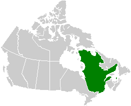
Français : Carte du Québec situé par rapport au Canada. Voir Image:Canada provinces blank vide.png pour de renseignements supplémentaires.
English: Map of Quebec with respect to Canada. See Image:Canada provinces blank vide.png for additional information. |
| Date | 24 September 2005 (original upload date) |
| Source | No machine-readable source provided. Own work assumed (based on copyright claims). |
| Author | No machine-readable author provided. QuartierLatin1968 assumed (based on copyright claims). |
Licensing
[edit]
| I, the copyright holder of this work, release this work into the public domain. This applies worldwide. In some countries this may not be legally possible; if so: I grant anyone the right to use this work for any purpose, without any conditions, unless such conditions are required by law. |
File history
Click on a date/time to view the file as it appeared at that time.
| Date/Time | Thumbnail | Dimensions | User | Comment | |
|---|---|---|---|---|---|
| current | 02:20, 24 September 2005 | | 262 × 212 (5 KB) | QuartierLatin1968 (talk | contribs) | * {{français}} Carte du Québec situé par rapport au Canada. Voir Image:Canada provinces blank vide.png pour de renseignements supplémentaires. * {{english}} Map of Quebec with respect to Canada. See Image:Canada provinces blank vide.png for |
You cannot overwrite this file.
File usage on Commons
There are no pages that use this file.
File usage on other wikis
The following other wikis use this file: