File:CampañaRumanaSeptiembreNoviembre1916Enero1917.svg
Jump to navigation
Jump to search

Size of this PNG preview of this SVG file: 783 × 600 pixels. Other resolutions: 313 × 240 pixels | 627 × 480 pixels | 1,003 × 768 pixels | 1,280 × 980 pixels | 2,560 × 1,961 pixels | 2,538 × 1,944 pixels.
Original file (SVG file, nominally 2,538 × 1,944 pixels, file size: 1.33 MB)
Captions
Captions
Add a one-line explanation of what this file represents
| Description |
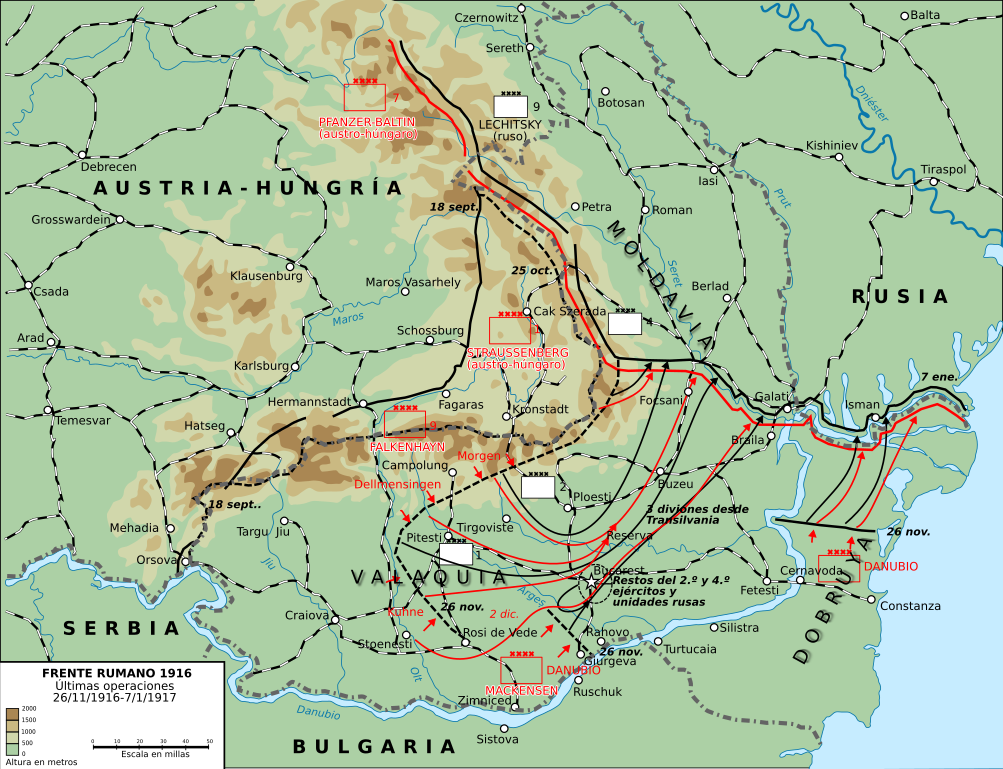
English: This map shows the conquest of Romania: November 1916 through till January of 1917
This map was created by the Department of Military Art and Engineering, at the U.S. Military Academy (West Point). The initial version was created under the supervision of General Vincent Esposito in 1959. It is now available on the West Point web site at: http://www.dean.usma.edu/history/web03/atlases/great%20war/great%20war%20%20pages/great%20war%20map%2037.htm
Español: Últimas operaciones de la campaña rumana de 1916: la retirada a Moldavia y la toma por los Imperios Centrales de Dobruja y Valaquia. |
||
| Date | (UTC) | ||
| Source | |||
| Author |
|

| This is a retouched picture, which means that it has been digitally altered from its original version. Modifications: turned into svg and Spanish. The original can be viewed here: Romania-WW1-3.jpg:
|
This file is licensed under the Creative Commons Attribution-Share Alike 3.0 Unported license.
- You are free:
- to share – to copy, distribute and transmit the work
- to remix – to adapt the work
- Under the following conditions:
- attribution – You must give appropriate credit, provide a link to the license, and indicate if changes were made. You may do so in any reasonable manner, but not in any way that suggests the licensor endorses you or your use.
- share alike – If you remix, transform, or build upon the material, you must distribute your contributions under the same or compatible license as the original.
Original upload log[edit]
This image is a derivative work of the following images:
- File:Romania-WW1-3.jpg licensed with PD-USGov
- 2006-12-28T16:42:16Z Electionworld 1018x868 (162492 Bytes) {{ew|en|Cglassey}} == Summary == This map shows the conquest of Romania: November 1916 through till January of 1917 This map was created by the Department of Military Art and Engineering, at the U.S. Military Academy (West P
Uploaded with derivativeFX
File history
Click on a date/time to view the file as it appeared at that time.
| Date/Time | Thumbnail | Dimensions | User | Comment | |
|---|---|---|---|---|---|
| current | 22:01, 7 October 2017 | | 2,538 × 1,944 (1.33 MB) | Rowanwindwhistler (talk | contribs) | Size |
| 21:51, 7 October 2017 |  | 2,553 × 2,000 (1.29 MB) | Rowanwindwhistler (talk | contribs) | Region names, river names, Jiu river, legend... | |
| 09:03, 22 January 2017 |  | 1,284 × 983 (1.05 MB) | Rowanwindwhistler (talk | contribs) | Some minor errors corrected. Fake text added. | |
| 06:12, 4 February 2016 |  | 1,204 × 922 (474 KB) | Rowanwindwhistler (talk | contribs) | Some text moved for better readability | |
| 06:05, 4 February 2016 |  | 1,204 × 922 (474 KB) | Rowanwindwhistler (talk | contribs) | Minor corrections, some colours & symbols from https://en.wikipedia.org/wiki/Wikipedia:WikiProject_Maps/Conventions | |
| 15:36, 8 September 2010 |  | 1,242 × 961 (464 KB) | Rowanwindwhistler (talk | contribs) | Wrong unit deleted | |
| 15:33, 8 September 2010 |  | 1,242 × 961 (472 KB) | Rowanwindwhistler (talk | contribs) | {{Information |Description={{en|1=This map shows the conquest of Romania: November 1916 through till January of 1917 This map was created by the Department of Military Art and Engineering, at the U.S. Military Academy (West Point). The initial version was |
You cannot overwrite this file.
File usage on Commons
The following 4 pages use this file:
File usage on other wikis
The following other wikis use this file:
- Usage on ca.wikipedia.org
- Usage on es.wikipedia.org
- Usage on fr.wikipedia.org
- Usage on sh.wikipedia.org
- Usage on uk.wikipedia.org