File:Cambrian line Map.png
Jump to navigation
Jump to search

Size of this preview: 800 × 398 pixels. Other resolutions: 320 × 159 pixels | 640 × 318 pixels | 1,024 × 509 pixels | 1,280 × 636 pixels | 2,560 × 1,273 pixels | 5,374 × 2,672 pixels.
Original file (5,374 × 2,672 pixels, file size: 5.51 MB, MIME type: image/png)
Captions
Captions
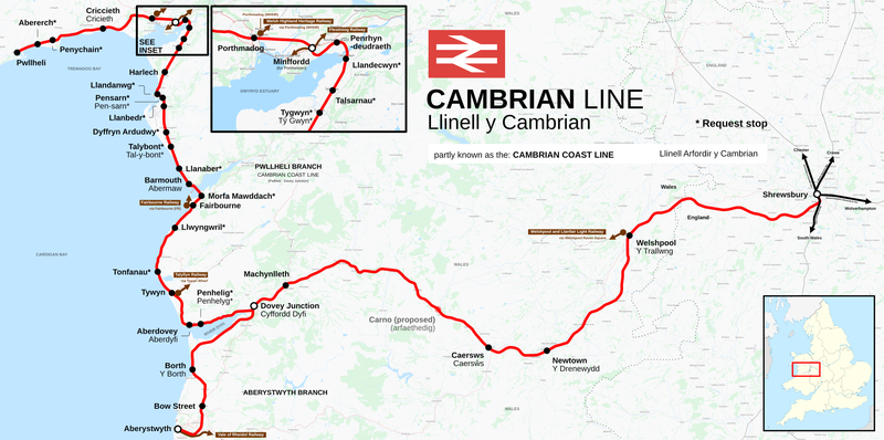
Map of the Cambrian railway line
Summary
[edit]
| Description |
English: Map of the Cambrian line (sometimes split into the Cambrian Main Line and Cambrian Coast Line), a railway line of the Wales and Borders franchise, between Shrewsbury, England, and Aberystwyth and Pwllheli, Wales, splitting at Dovey Junction. Translations of stations in Welsh are labelled on the map underneath the English name, a lack of translation means the only name present is used in both Welsh and English. Request stops are marked with an asterisk (*). Heritage railway lines are coloured brown. Nearby heritage stations are grouped with National Rail stations into a singular interchange station (marked with black and white roundel), and station name under "via". Map made to style produced by Rcsprinter123. This map may not be complete, and should not be used solely for navigation. |
|||
| Date | ||||
| Source |
Own work This image includes elements that have been taken or adapted from this file: This image includes elements that have been taken or adapted from this file: |
|||
| Author | DankJae; OpenStreetMap contributors | |||
| Permission (Reusing this file) |
Contains imagery from OSM Transport Map Style, produced by Thunderforest, released under CC-BY-SA 2.0. Maps © Thunderforest, Data © OpenStreetMap contributors. |
Licensing
[edit]
I, the copyright holder of this work, hereby publish it under the following license:
This file is licensed under the Creative Commons Attribution-Share Alike 4.0 International license.
- You are free:
- to share – to copy, distribute and transmit the work
- to remix – to adapt the work
- Under the following conditions:
- attribution – You must give appropriate credit, provide a link to the license, and indicate if changes were made. You may do so in any reasonable manner, but not in any way that suggests the licensor endorses you or your use.
- share alike – If you remix, transform, or build upon the material, you must distribute your contributions under the same or compatible license as the original.
File history
Click on a date/time to view the file as it appeared at that time.
| Date/Time | Thumbnail | Dimensions | User | Comment | |
|---|---|---|---|---|---|
| current | 13:04, 26 February 2023 | | 5,374 × 2,672 (5.51 MB) | DankJae (talk | contribs) | Font change, moved some labels |
| 15:55, 2 August 2022 |  | 5,374 × 2,672 (5.46 MB) | DankJae (talk | contribs) | minor text and marker edits | |
| 23:23, 22 June 2022 |  | 5,374 × 2,672 (5.43 MB) | DankJae (talk | contribs) | Uploaded own work with UploadWizard |
You cannot overwrite this file.
File usage on Commons
The following 11 pages use this file:
- User:Chumwa/OgreBot/Public transport information/2022 August 1-10
- User:Chumwa/OgreBot/Public transport information/2022 June 21-30
- User:Chumwa/OgreBot/Public transport information/2023 February 19-28
- User:Chumwa/OgreBot/Transport Maps/2022 August 1-10
- User:Chumwa/OgreBot/Transport Maps/2022 June 21-30
- User:Chumwa/OgreBot/Transport Maps/2023 February 19-28
- User:DankJae
- User:Mattbuck/Railways/2022 August
- User:Mattbuck/Railways/2022 June
- User:Mattbuck/Railways/2023 February
- Category:Cambrian Line
File usage on other wikis
The following other wikis use this file:
- Usage on en.wikipedia.org
- Usage on ru.wikipedia.org
- Usage on www.wikidata.org