File:California map showing Alameda County.png
Jump to navigation
Jump to search
No higher resolution available.
California_map_showing_Alameda_County.png (200 × 231 pixels, file size: 22 KB, MIME type: image/png)
Captions
Captions
Add a one-line explanation of what this file represents
| Description |
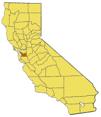
English: Map of Alameda county in California. |
| Source | From en:wiki |
| Author | user:Pyramide |

|
Permission is granted to copy, distribute and/or modify this document under the terms of the GNU Free Documentation License, Version 1.2 or any later version published by the Free Software Foundation; with no Invariant Sections, no Front-Cover Texts, and no Back-Cover Texts. A copy of the license is included in the section entitled GNU Free Documentation License. |
| This file is licensed under the Creative Commons Attribution-Share Alike 3.0 Unported license. | ||
| ||
| This licensing tag was added to this file as part of the GFDL licensing update. |
File history
Click on a date/time to view the file as it appeared at that time.
| Date/Time | Thumbnail | Dimensions | User | Comment | |
|---|---|---|---|---|---|
| current | 16:51, 1 July 2005 | | 200 × 231 (22 KB) | Pyramide~commonswiki (talk | contribs) | Map of Alameda county in California. From en: {{GFDL}} Category:Maps of counties in California |
You cannot overwrite this file.
File usage on Commons
There are no pages that use this file.
File usage on other wikis
The following other wikis use this file:
- Usage on bg.wikipedia.org
- Usage on en.wikipedia.org
- Altamont, California
- Monument Peak (Milpitas, California)
- Mount Allison
- William Joseph McInnes Botanic Garden and Campus Arboretum
- Grand Lake, Oakland, California
- Murray Township, Alameda County, California
- Brooklyn, California
- Alvarado, California
- Decoto, California
- Elmhurst, Oakland, California
- Sequoyah Heights, Oakland, California
- Grass Valley, Oakland, California
- Seminary, Oakland, California
- San Leandro Oyster Beds
- Adams Point, Oakland, California
- Labadie Arboretum
- Maxwell Park, Oakland, California
- Sunol Valley
- Ridgemont, Oakland, California
- Trestle Glen, Oakland, California
- Old Oakland
- Grizzly Peak (Berkeley Hills)
- Westbrae, Berkeley, California
- Cragmont, Berkeley, California
- Lorin District, Berkeley, California
- Oakmore, Oakland, California
- Network of Bay Area Worker Cooperatives
- Crocker Highlands, Oakland, California
- Best Manufacturing Company
- Template:AlamedaCountyCA-geo-stub
- Bethany Reservoir
View more global usage of this file.