File:Cadillac Mountain, Acadia National Park, Maine - 68554907.jpg

Original file (2,048 × 1,385 pixels, file size: 3.08 MB, MIME type: image/jpeg)
Captions
Captions
Summary
[edit]
| Description |
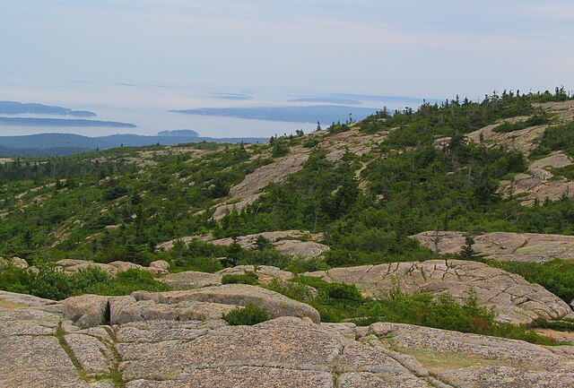
English: Cadillac Mountain is a mountain located on Mount Desert Island, within Acadia National Park. With an elevation of 1,528 feet (470 m), its summit is the highest point in Hancock County and the highest within 25 miles (40 km) of the shoreline of the North American continent between the Cape Breton Highlands, Nova Scotia and Mexican peaks 180 miles (290 km) south of the Texas border.
Before being renamed in 1918, the mountain had been called Green Mountain. The new name honors the French explorer and adventurer, Antoine Laumet de La Mothe, sieur de Cadillac. In 1688, De la Mothe requested and received from the Governor of New France a parcel of land in an area known as Donaquec which included part of the Donaquec River (now the Union River) and the island of Mount Desert in the present-day U.S. state of Maine. Antoine Laumet de La Mothe, a shameless self-promoter who had already appropriated the "de la Mothe" portion of his name from a local nobleman in his native Picardy, thereafter referred to himself as Antoine de la Mothe, sieur de Cadillac, Donaquec, and Mount Desert. There are various hiking trails to the summit of Cadillac Mountain, some more challenging than others. There is also a paved road to the top. Driving or hiking to the summit of Cadillac Mountain to see "the nation's first sunrise" is a popular activity among visitors of Acadia National Park. However, Cadillac only sees the first sunrise in the fall and winter, when the sun rises south of due east. During most of the spring and summer, the sun rises first on Mars Hill, 150 miles (240 km) to the northeast. For a few weeks around the equinoxes, the sun rises first at West Quoddy Head in Lubec, Maine, the easternmost town in the United States. On exceptionally clear days, it is possible to see Mount Katahdin, Maine's highest mountain, to the north and the Canadian province of Nova Scotia to the east, both over one hundred miles away. en.wikipedia.org/wiki/Cadillac_Mountain en.wikipedia.org/wiki/Wikipedia:Text_of_Creative_Commons_... |
| Date | Taken on 6 August 2004, 12:50:23 |
| Source | https://www.flickr.com/photos/75683070@N00/68554907/ |
| Author | Ken Lund |
| Camera location | | View this and other nearby images on: OpenStreetMap |
|---|
Licensing
[edit]
- You are free:
- to share – to copy, distribute and transmit the work
- to remix – to adapt the work
- Under the following conditions:
- attribution – You must give appropriate credit, provide a link to the license, and indicate if changes were made. You may do so in any reasonable manner, but not in any way that suggests the licensor endorses you or your use.
- share alike – If you remix, transform, or build upon the material, you must distribute your contributions under the same or compatible license as the original.
| This image was originally posted to Flickr by Ken Lund at https://flickr.com/photos/75683070@N00/68554907. It was reviewed on 15 June 2022 by FlickreviewR 2 and was confirmed to be licensed under the terms of the cc-by-sa-2.0. |
File history
Click on a date/time to view the file as it appeared at that time.
| Date/Time | Thumbnail | Dimensions | User | Comment | |
|---|---|---|---|---|---|
| current | 02:02, 15 June 2022 | | 2,048 × 1,385 (3.08 MB) | Leonaardog (talk | contribs) | Uploaded a work by Ken Lund from https://www.flickr.com/photos/75683070@N00/68554907/ with UploadWizard |
You cannot overwrite this file.
File usage on Commons
The following page uses this file:
.jpg&redirect=no)