File:Cadel Evans Great Ocean Road Race 2015 (B).jpg
Jump to navigation
Jump to search

Size of this preview: 710 × 600 pixels. Other resolutions: 284 × 240 pixels | 568 × 480 pixels | 909 × 768 pixels | 1,212 × 1,024 pixels | 1,928 × 1,629 pixels.
Original file (1,928 × 1,629 pixels, file size: 1.97 MB, MIME type: image/jpeg)
Captions
Captions
Add a one-line explanation of what this file represents
| Description |
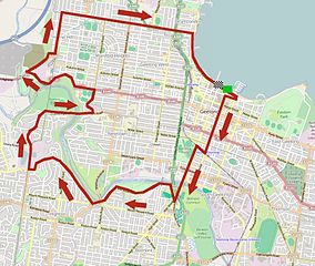
Parcours du circuit local de la Cadel Evans Great Ocean Road Race 2015. This map was created from OpenStreetMap project data, collected by the community. This map may be incomplete, and may contain errors. Don't rely solely on it for navigation. |
|||
| Date | ||||
| Source | You may find a page on the OpenStreetMap wiki page for Cadel Evans Great Ocean Road Race 2015 | |||
| Creator |
OpenStreetMap contributors, Jérémy-Günther-Heinz Jähnick, d'après une carte réalisé par les organisateurs de la Cadel Evans Great Ocean Road Race 2015. OpenStreetMap contributors |
|||
| Permission (Reusing this file) |
OpenStreetMap data is available under the Open Database License (details). Map tiles are licensed under the Creative Commons Attribution-ShareAlike 2.0 license (CC-BY-SA 2.0).
This file is licensed under the Creative Commons Attribution-Share Alike 2.0 Generic license.
|
|||
| Georeferencing | If inappropriate please set warp_status = skip to hide. | |||
| Other versions |
.jpg)
File history
Click on a date/time to view the file as it appeared at that time.
| Date/Time | Thumbnail | Dimensions | User | Comment | |
|---|---|---|---|---|---|
| current | 13:13, 15 January 2015 | | 1,928 × 1,629 (1.97 MB) | Jérémy-Günther-Heinz Jähnick (talk | contribs) | {{OpenStreetMap |name = Cadel Evans Great Ocean Road Race 2015 |location = |description = Parcours du circuit local de la Cadel Evans Great Ocean Road Race 2015. |top = |bottom = |left = |right = |... |
You cannot overwrite this file.
File usage on Commons
There are no pages that use this file.
File usage on other wikis
The following other wikis use this file:
- Usage on fr.wikipedia.org
- Usage on fr.wikinews.org
.jpg&oldid=845222563)