File:CTrain Route Map with GL Stage 1 (schematic).svg
Jump to navigation
Jump to search

Size of this PNG preview of this SVG file: 476 × 600 pixels. Other resolutions: 190 × 240 pixels | 381 × 480 pixels | 609 × 768 pixels | 813 × 1,024 pixels | 1,625 × 2,048 pixels | 865 × 1,090 pixels.
Original file (SVG file, nominally 865 × 1,090 pixels, file size: 31 KB)
Captions
Captions
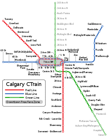
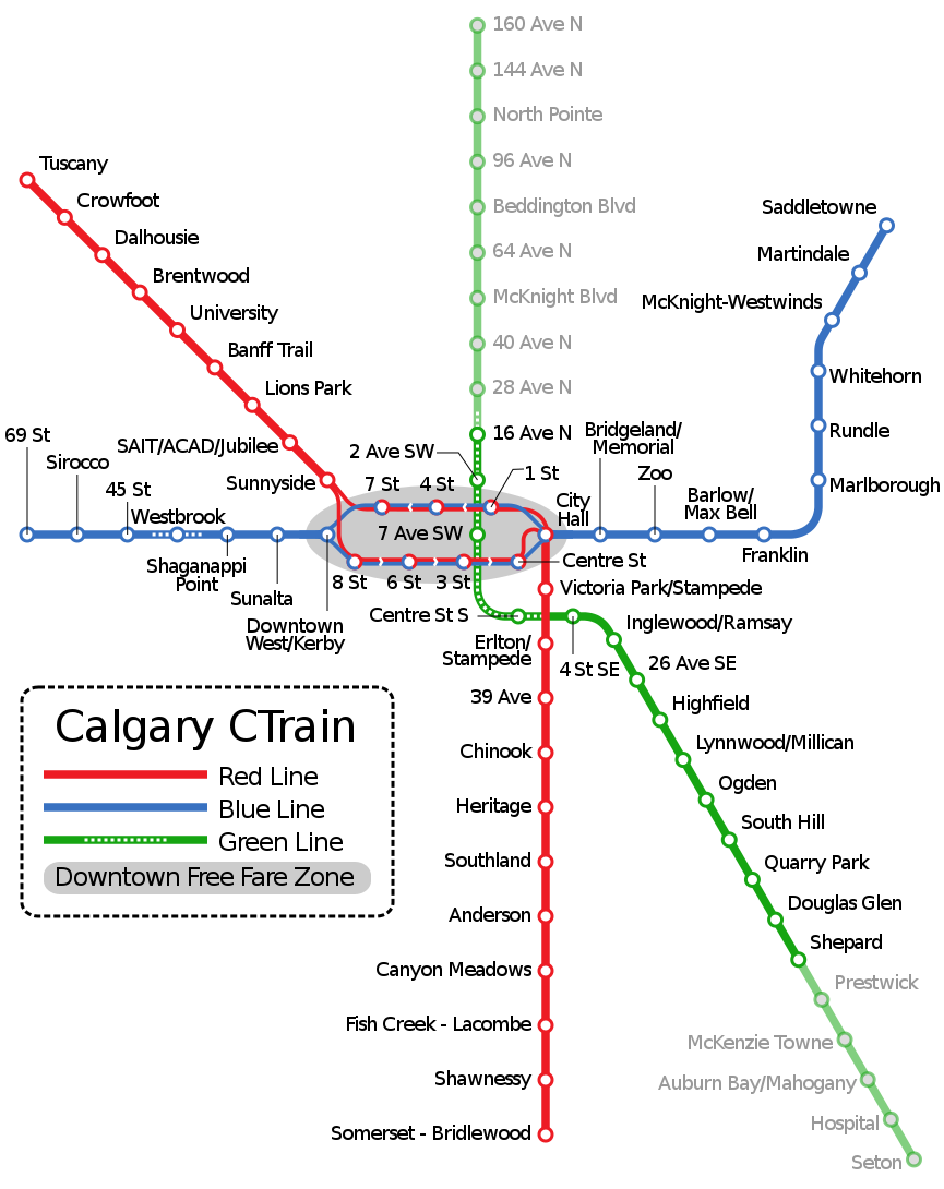
Schematic map of Calgary CTrain system, including Green Line (Stage 1 emphasized).
Summary
[edit].svg&action=edit§ion=1)
| Description |
English: Schematic map of Calgary CTrain system, including Green Line, with Stage 1 of the Green Line emphasized. As of 2019, there is no schedule or funding to complete the entire Green Line. |
| Date | |
| Source | Own work |
| Author | Mliu92 |
| Other versions |
This file was derived from: CTrain Route Map with GL (schematic).svg: .svg) |
Licensing
[edit].svg&action=edit§ion=2)
I, the copyright holder of this work, hereby publish it under the following license:
This file is licensed under the Creative Commons Attribution-Share Alike 4.0 International license.
- You are free:
- to share – to copy, distribute and transmit the work
- to remix – to adapt the work
- Under the following conditions:
- attribution – You must give appropriate credit, provide a link to the license, and indicate if changes were made. You may do so in any reasonable manner, but not in any way that suggests the licensor endorses you or your use.
- share alike – If you remix, transform, or build upon the material, you must distribute your contributions under the same or compatible license as the original.
File history
Click on a date/time to view the file as it appeared at that time.
| Date/Time | Thumbnail | Dimensions | User | Comment | |
|---|---|---|---|---|---|
| current | 02:04, 21 May 2019 | | 865 × 1,090 (31 KB) | Mliu92 (talk | contribs) | Fixed color for 16 Ave N station label. |
| 16:19, 20 May 2019 |  | 865 × 1,090 (31 KB) | Mliu92 (talk | contribs) | Redrew Red Line around City Hall | |
| 17:32, 17 May 2019 |  | 865 × 1,090 (39 KB) | Mliu92 (talk | contribs) | User created page with UploadWizard |
You cannot overwrite this file.
File usage on Commons
The following 9 pages use this file:
- User:Chumwa/OgreBot/Potential transport maps/2019 May 11-20
- User:Chumwa/OgreBot/Potential transport maps/2019 May 21-31
- User:Chumwa/OgreBot/Public transport information/2019 May 11-20
- User:Chumwa/OgreBot/Public transport information/2019 May 21-31
- User:Chumwa/OgreBot/Transport Maps/2019 May 11-20
- User:Chumwa/OgreBot/Transport Maps/2019 May 21-31
- User:Chumwa/OgreBot/Travel and communication maps/2019 May 11-20
- User:Chumwa/OgreBot/Travel and communication maps/2019 May 21-31
- File:CTrain Route Map (all proposed).svg
.svg)
File usage on other wikis
The following other wikis use this file:
- Usage on ja.wikipedia.org
.svg&oldid=844889980)