File:CTB01RtMap.png
Jump to navigation
Jump to search

Size of this preview: 800 × 314 pixels. Other resolutions: 320 × 126 pixels | 640 × 251 pixels | 1,024 × 402 pixels | 1,280 × 503 pixels | 3,394 × 1,333 pixels.
Original file (3,394 × 1,333 pixels, file size: 823 KB, MIME type: image/png)
Captions
Captions
Add a one-line explanation of what this file represents
Summary
[edit]
| Description |
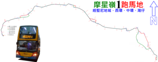
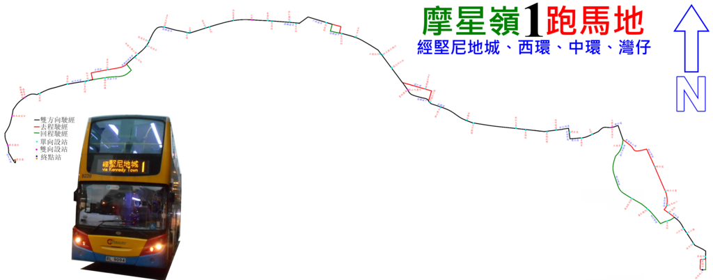
中文(香港):城巴1號線的走線圖 |
| Date | |
| Source | Own work |
| Author | ATR50 |
Licensing
[edit]
I, the copyright holder of this work, hereby publish it under the following license:
This file is licensed under the Creative Commons Attribution-Share Alike 3.0 Unported license.
- You are free:
- to share – to copy, distribute and transmit the work
- to remix – to adapt the work
- Under the following conditions:
- attribution – You must give appropriate credit, provide a link to the license, and indicate if changes were made. You may do so in any reasonable manner, but not in any way that suggests the licensor endorses you or your use.
- share alike – If you remix, transform, or build upon the material, you must distribute your contributions under the same or compatible license as the original.
File history
Click on a date/time to view the file as it appeared at that time.
| Date/Time | Thumbnail | Dimensions | User | Comment | |
|---|---|---|---|---|---|
| current | 15:50, 25 December 2016 | 3,394 × 1,333 (823 KB) | ATR50~commonswiki (talk | contribs) | 2016年12月換圖 | |
| 03:10, 13 May 2015 | 3,394 × 1,333 (620 KB) | ATR50~commonswiki (talk | contribs) | 2015年5月路線延駛至摩星嶺﹐取代5路線 | ||
| 03:16, 22 May 2014 |  | 3,149 × 1,333 (652 KB) | ATR50~commonswiki (talk | contribs) | User created page with UploadWizard |
You cannot overwrite this file.
File usage on Commons
The following 9 pages use this file:
- User:Chumwa/OgreBot/Potential transport maps/2016 December 21-31
- User:Chumwa/OgreBot/Public transport information/2015 May 11-20
- User:Chumwa/OgreBot/Public transport information/2016 December 21-31
- User:Chumwa/OgreBot/Transport Maps/2015 May 11-20
- User:Chumwa/OgreBot/Transport Maps/2016 December 21-31
- User:Chumwa/OgreBot/Travel and communication maps/2016 December 21-31
- User:OgreBot/Watercraft/2016 December 25
- User:Pechristener/Bridges/2014 May 21-31
- User:Pechristener/Bridges/2015 May 11-20
File usage on other wikis
The following other wikis use this file:
- Usage on en.wikipedia.org
- Usage on zh.wikipedia.org