File:CSUN Digital - Title Map of Rancho el Encino, 1873.jpg
Original file (1,148 × 1,778 pixels, file size: 297 KB, MIME type: image/jpeg)
Captions
Captions
Summary
[edit]
| Description |
English: CSUN Digital - Title Map of Rancho el Encino, 1873 |
| Date | |
| Source |
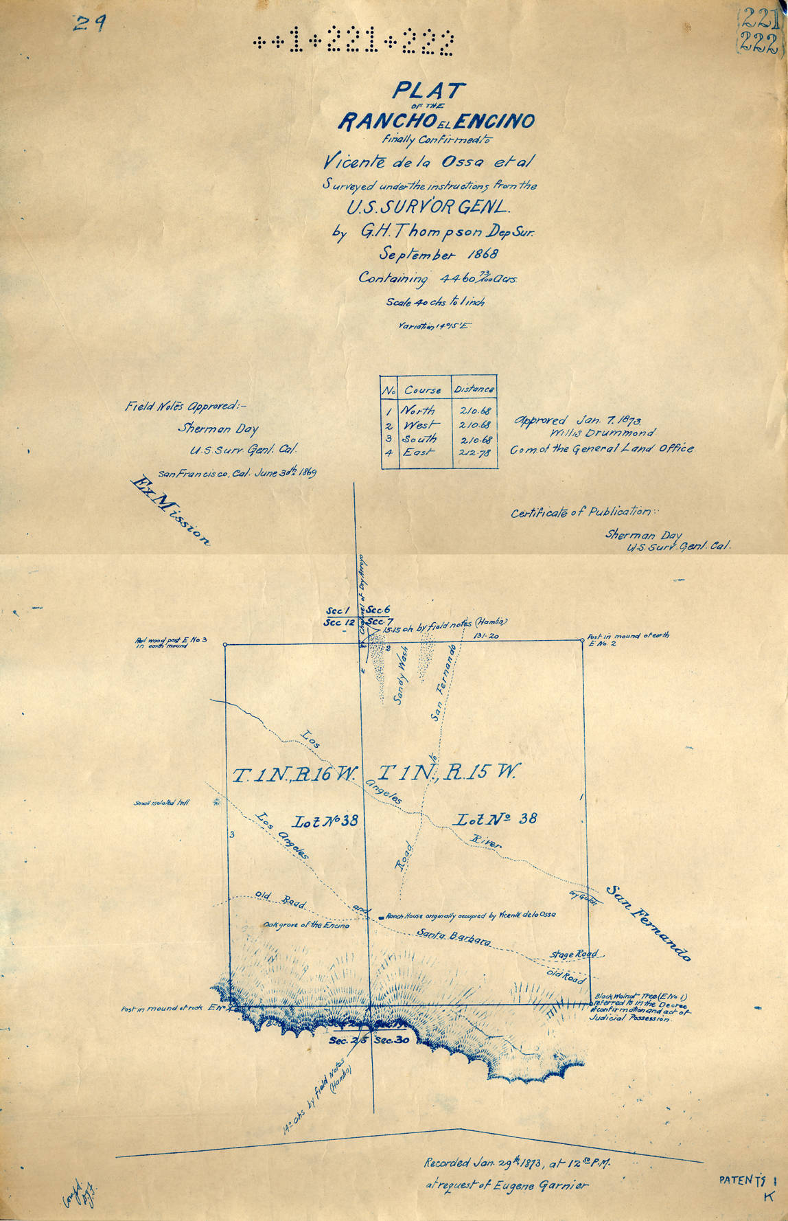
https://digital-collections.csun.edu/digital/collection/SFVH/id/2021 Title Map of Rancho el Encino, 1873 Description A copy of the survey map confirming the holdings of Vincente de la Ossa at Rancho el Encino. The map was registered on January 29, 1873 and approved by Sherman Day, the U.S. Surveyor General of California and Willis Drummond, Commissioner of the General Land Office. The survey this map is based upon was done in September 1868. The rancho contained 4460 acres. Facsimile copy of map. 18 x 12 in. Photographer/Author/Interviewee United States. Surveyor General Neighborhood Encino (Los Angeles, Calif.) Subject Rancho El Encino (Encino, Los Angeles, Calif.) Land grants Ranches Type image text Language eng Medium Map Format-Extent 46 x 30 cm. Contributing Repository Rancho Los Encinos (Encino, Los Angeles, Calif.) Digital Format image/jpeg Identifier RLE41.jpg Digital Collection San Fernando Valley History Digital Library Digital Publisher California State University, Northridge Rights Note Works appearing in this collection are made available exclusively for educational purposes such as research or instruction. Inquiries into the status of copyright should be directed to the designated repository via the rights contact information. Transmission or reproduction of materials protected by U.S. Copyright Law (Title 17, U.S.C.) beyond that allowed by fair use requires the written permission of the copyright owners. Works not in the public domain cannot be commercially exploited without permission of the copyright owners. Responsibility for any use rests exclusively with the user. |
| Author | U. S. Surveyors |
Licensing
[edit]
This work is in the public domain in the United States because it was published (or registered with the U.S. Copyright Office) before January 1, 1929.
Public domain works must be out of copyright in both the United States and in the source country of the work in order to be hosted on the Commons. If the work is not a U.S. work, the file must have an additional copyright tag indicating the copyright status in the source country.
Note: This tag should not be used for sound recordings. |
File history
Click on a date/time to view the file as it appeared at that time.
| Date/Time | Thumbnail | Dimensions | User | Comment | |
|---|---|---|---|---|---|
| current | 19:00, 1 November 2023 | | 1,148 × 1,778 (297 KB) | Jengod (talk | contribs) | Uploaded a work by U. S. Surveyors from https://digital-collections.csun.edu/digital/collection/SFVH/id/2021 Title Map of Rancho el Encino, 1873 Description A copy of the survey map confirming the holdings of Vincente de la Ossa at Rancho el Encino. The map was registered on January 29, 1873 and approved by Sherman Day, the U.S. Surveyor General of California and Willis Drummond, Commissioner of the General Land Office. The survey this map is based upon was done in September 1868. The rancho... |
You cannot overwrite this file.
File usage on Commons
There are no pages that use this file.