File:CR 492 Marquette County MI.svg
Jump to navigation
Jump to search

Size of this PNG preview of this SVG file: 636 × 376 pixels. Other resolutions: 320 × 189 pixels | 640 × 378 pixels | 1,024 × 605 pixels | 1,280 × 757 pixels | 2,560 × 1,513 pixels.
Original file (SVG file, nominally 636 × 376 pixels, file size: 247 KB)
Captions
Captions
Add a one-line explanation of what this file represents
Summary
[edit]
| Description |
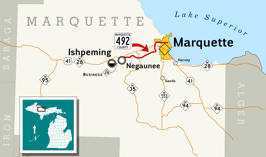
English: Map of County Road 492 in Marquette County, Michigan.
Español: Mapa de Carretera Condado 492 en el Condado de Marquette, Michigan. |
| Date | |
| Source | Created with KML data on English Wikipedia (red line), File:Marquette County, Mich.svg (base map), and File:Blank map of Michigan.svg (inset). |
| Author | ThrawnRocks and Ruhrfisch (inset), Scott Nazelrod (everything else) |
| Permission (Reusing this file) |
CC-BY-SA 3.0 |
Licensing
[edit]
This file is licensed under the Creative Commons Attribution-Share Alike 3.0 Unported license.
- You are free:
- to share – to copy, distribute and transmit the work
- to remix – to adapt the work
- Under the following conditions:
- attribution – You must give appropriate credit, provide a link to the license, and indicate if changes were made. You may do so in any reasonable manner, but not in any way that suggests the licensor endorses you or your use.
- share alike – If you remix, transform, or build upon the material, you must distribute your contributions under the same or compatible license as the original.
File history
Click on a date/time to view the file as it appeared at that time.
| Date/Time | Thumbnail | Dimensions | User | Comment | |
|---|---|---|---|---|---|
| current | 08:27, 6 May 2013 | | 636 × 376 (247 KB) | Scott5114 (talk | contribs) | {{Information |Description={{en|Map of County Road 492 in Marquette County, Michigan.}} {{es|Mapa de Carretera Condado 492 en el Condado de Marquette, Michigan.}} |Source=Created KML data on English Wi... |
You cannot overwrite this file.
File usage on Commons
There are no pages that use this file.
File usage on other wikis
The following other wikis use this file:
- Usage on www.wikidata.org