File:COIN (FindID 1013719).jpg
Jump to navigation
Jump to search

Size of this preview: 800 × 461 pixels. Other resolutions: 320 × 184 pixels | 640 × 369 pixels | 1,024 × 590 pixels | 1,280 × 737 pixels | 2,560 × 1,475 pixels | 3,600 × 2,074 pixels.
Original file (3,600 × 2,074 pixels, file size: 2.42 MB, MIME type: image/jpeg)
Captions
Captions
Add a one-line explanation of what this file represents
Summary
[edit].jpg&action=edit§ion=1)
| COIN | |||
|---|---|---|---|
| Photographer |
Somerset County Council, Wil Partridge, 2018-05-17 11:54:43 |
||
| Title |
COIN |
||
| Description |
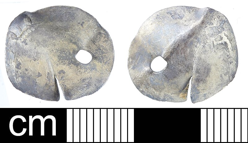
English: A Medieval to Post-Medieval copper alloy thimble, probably dating to c. 1400-1600. The thimble has a domed top and sloping sides. The drilled circular pits are arranged in a spiral leaving a bald tonsure at the apex of the thimble as well as a plain band around the rim. The pits are regularly arranged, although with some slight variation in depth. The rim has been crushed slightly, with a single small split in the metal.
Dimensions: height 21.6mm, Diam: 19.9, Thickness of metal: 2mm; it weighs 12.2g Holmes (1988) notes that bald tonsures are a feature of earlier thimbles, becoming less common with time and disappearing by c. 1650, whilst the spiral arrangment of pits seen here had become ubiquitous by 1500. He (ibid: fig. 2) illustrates similar examples dating to 1400-1550, and a similar, or potentially slightly later, date seems likely here |
||
| Depicted place | (County of findspot) Oxfordshire | ||
| Date | between 1400 and 1600 | ||
| Accession number |
FindIdentifier: finds-1013719 Old ref: BERK-DB561C Filename: BERKDB561C.jpg |
||
| Credit line |
|
||
| Source |
https://finds.org.uk/database/ajax/download/id/1013719 Catalog: https://finds.org.uk/database/images/image/id/1013719/recordtype/artefacts archive copy at the Wayback Machine Artefact: https://finds.org.uk/database/artefacts/record/id/1013719 |
||
| Permission (Reusing this file) |
Attribution License | ||
| Object location | | View this and other nearby images on: OpenStreetMap |
|---|
.jpg¶ms=051.533600_N_-000.988727_E_globe:Earth_class:object_type:object__&language=en)
Licensing
[edit].jpg&action=edit§ion=2)
This file is licensed under the Creative Commons Attribution 2.0 Generic license.
Attribution: Somerset County Council
- You are free:
- to share – to copy, distribute and transmit the work
- to remix – to adapt the work
- Under the following conditions:
- attribution – You must give appropriate credit, provide a link to the license, and indicate if changes were made. You may do so in any reasonable manner, but not in any way that suggests the licensor endorses you or your use.
File history
Click on a date/time to view the file as it appeared at that time.
| Date/Time | Thumbnail | Dimensions | User | Comment | |
|---|---|---|---|---|---|
| current | 21:47, 26 October 2020 | | 3,600 × 2,074 (2.42 MB) | Fæ (talk | contribs) | Portable Antiquities Scheme, DEV, FindID: finds-1013719, medieval, page 10, batch count 197 |
You cannot overwrite this file.
File usage on Commons
The following page uses this file:
.jpg)
.jpg&oldid=844162658)