File:Byzantine Constantinople-tr.svg
(Redirected from File:Byzantine Constantinople tr.svg)

Size of this PNG preview of this SVG file: 664 × 599 pixels. Other resolutions: 266 × 240 pixels | 532 × 480 pixels | 851 × 768 pixels | 1,135 × 1,024 pixels | 2,269 × 2,048 pixels | 2,050 × 1,850 pixels.
Original file (SVG file, nominally 2,050 × 1,850 pixels, file size: 1.65 MB)
Captions
Captions
Add a one-line explanation of what this file represents
Summary
[edit]| Description |
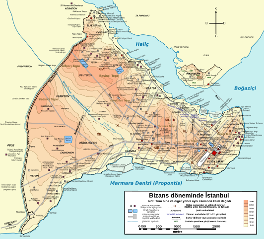
Türkçe: Konstantinopolis'in Bizans dönemindeki topografik haritası. Ana haritanın kaynağı: R. Janin, Constantinople Byzantine. Developpement urbain et repertoire topographique. Yol haritası ve bazı diğer ayrıntıların kaynağı: Dumbarton Oaks Papers 54; kiliseler, özellikle kimliği belirlenmemiş olanlar hakkında veriler, New York University'nin İstanbul'un Bizans Kiliseleri projesinden elde edilmiştir. Şehir hakkında yayımlanmış diğer harita ve metinler bu bilgileri doğrulamak için kullanılmıştır.
English: Topographical map of Constantinople during the Byzantine period. Main map source: R. Janin, Constantinople Byzantine. Developpement urbain et repertoire topographique. Road network and some other details based on Dumbarton Oaks Papers 54; data on many churches, especially unidentified ones, taken from the University of New York's The Byzantine Churches of Istanbul project. Other published maps and accounts of the city have been used for corroboration. Български: Топографска карта на Константинопол (Цариград) през византийския период. Източник: R. Janin, Constantinople Byzantine. Developpement urbain et repertoire topographique. Пътната мрежа и някои други детайли се основават на Dumbarton Oaks Papers 54 и други публикувани източници. Deutsch: Topografische Karte Konstantinopels während des byzantinischen Zeitraums. Quelle: R. Janin, Constantinople Byzantine. Developpement urbain et repertoire topographique. Straßennetz und andere Einzelheiten basiert auf Dumbarton Oaks Papers 54. Kirchen, insb. nicht identifizierte und ausgegrabene Bauten sind aus dem The Byzantine Churches of Istanbul entnommen. Andere herausgegebenen Quellen wurden behilfsmäßig gebraucht. Ελληνικά: Τοπογραφικός χάρτης Κωνσταντινουπόλεως κατά τη Βυζαντινή περίοδο. Βασική πηγή χάρτη: R. Janin, Constantinople Byzantine. Developpement urbain et repertoire topographique. Το οδικό δίκτυο και διάφορες άλλες λεπτομέρειες με βάση το Dumbarton Oaks Papers 54. Πληροφορίες για μη ταυτοποιημένες εκκλησίες από την ιστοσελίδα The Byzantine Churches of Istanbul του Πανεπιστημίου της Νέας Υόρκης. Although I've striven to make this map as complete and correct as possible, there may be some errors or omissions. Any corrections & suggestions are welcome. |
| Date | (UTC) |
| Source | |
| Author |
|
| Other versions |
[] Full maps[edit]SVG:
PNG:
Numeric versions[edit]
Regions[edit]
Roads[edit]
|


| This is a retouched picture, which means that it has been digitally altered from its original version. Modifications: translated labels to Turkish. The original can be viewed here: Byzantine Constantinople-en.svg:
|
I, the copyright holder of this work, hereby publish it under the following licenses:
This file is licensed under the Creative Commons Attribution-Share Alike 3.0 Unported license.
- You are free:
- to share – to copy, distribute and transmit the work
- to remix – to adapt the work
- Under the following conditions:
- attribution – You must give appropriate credit, provide a link to the license, and indicate if changes were made. You may do so in any reasonable manner, but not in any way that suggests the licensor endorses you or your use.
- share alike – If you remix, transform, or build upon the material, you must distribute your contributions under the same or compatible license as the original.

|
Permission is granted to copy, distribute and/or modify this document under the terms of the GNU Free Documentation License, Version 1.2 or any later version published by the Free Software Foundation; with no Invariant Sections, no Front-Cover Texts, and no Back-Cover Texts. A copy of the license is included in the section entitled GNU Free Documentation License. |
You may select the license of your choice.
Original upload log
[edit]
This image is a derivative work of the following images:
- File:Byzantine_Constantinople.svg licensed with Cc-by-sa-3.0, GFDL
- 2009-12-15T13:13:22Z Cplakidas 2050x1850 (8520961 Bytes) larger & improved version, various corrections, Galata included
- 2009-01-08T22:53:05Z Cplakidas 1600x1500 (6068684 Bytes) {{Information |Description= |Source= |Date= |Author= |Permission= |other_versions= }}
- 2008-11-14T23:26:35Z Cplakidas 1600x1500 (5550805 Bytes) attempt to get text right
- 2008-10-28T11:38:36Z Cplakidas 1600x1500 (5570026 Bytes) final version (hopefully): added remaining churches & corrected locations, minor tweaks at places
- 2008-10-27T19:10:38Z Cplakidas 1600x1500 (5044456 Bytes) completed outer land wall, fixed Golden Gate, fixed sea walls & added known gates, minor location corrections & additions
- 2008-10-25T17:46:57Z Cplakidas 1600x1500 (2868866 Bytes) text into paths, enlarged map for improved readability
- 2008-10-24T00:59:09Z Cplakidas 1180x1120 (380180 Bytes) restored Times New Roman.
- 2008-10-24T00:39:44Z Cplakidas 1180x1120 (377994 Bytes) added posterns, alternate gate names, approx. roads in outer city, corrections on monastery locations, converted text to sans serif font
- 2008-10-23T22:47:55Z Cplakidas 1180x1120 (335598 Bytes) Reverted to version as of 23:25, 14 October 2008
- 2008-10-23T22:45:25Z Cplakidas 1180x1120 (344657 Bytes) added posterns, alternate gate names, approx. roads in outer city, minor tweaks
- 2008-10-14T23:25:51Z Cplakidas 1180x1120 (335598 Bytes) various tweaks & corrections, added some features
- 2008-10-14T12:19:50Z Cplakidas 1180x1120 (321445 Bytes) minor tweaks & corrections
- 2008-10-14T12:07:30Z Cplakidas 1180x1120 (324413 Bytes) minor tweaks & corrections
- 2008-10-13T23:23:57Z Cplakidas 1180x1120 (321907 Bytes) {{Information |Description={{en|1=Topographical map of [[Constantinople]] during the [[Byzantine Empire|Byzantine]] period. Map source: R. Janin, ''Constantinople Byzantine. Developpement urbain et repertoire topographique''.
Uploaded with derivativeFX
File history
Click on a date/time to view the file as it appeared at that time.
| Date/Time | Thumbnail | Dimensions | User | Comment | |
|---|---|---|---|---|---|
| current | 19:51, 8 August 2010 | | 2,050 × 1,850 (1.65 MB) | İnfoCan (talk | contribs) | {{Information |Description= |Source= |Date= |Author= |Permission= |other_versions= }} |
| 18:40, 28 June 2010 |  | 2,050 × 1,850 (1.64 MB) | InfoCan (talk | contribs) | {{Information |Description={{en|1=Topographical map of Constantinople during the Byzantine period. Main map source: R. Janin, ''Constantinople Byzantine. Developpement urbain et repertoire topographique''. Road network and some ot |
You cannot overwrite this file.
File usage on Commons
The following 16 pages use this file:
- File:Byzantine Constantinople-de.svg
- File:Byzantine Constantinople-el.svg
- File:Byzantine Constantinople-en.png
- File:Byzantine Constantinople-en.svg
- File:Byzantine Constantinople-pt.svg
- File:Byzantine Constantinople-tr.png
- File:Byzantine Constantinople-tr.svg
- File:Byzantine Constantinople - ce.svg
- File:Byzantine Constantinople - ru.svg
- File:Byzantine Constantinople - uk.svg
- File:Byzantine Constantinople eu.png
- File:Byzantine Constantinople eu.svg
- File:Byzantine Constantinople regiones.svg
- File:Byzantine Constantinople tr.svg (file redirect)
- File:Byzantine Constantinople viae.svg
- Template:Other versions/Byzantine Constantinople versions