File:Byhleguhre Grobbe 01.jpg
Original file (5,472 × 3,648 pixels, file size: 17.28 MB, MIME type: image/jpeg)
Captions
Summary
[edit]DescriptionByhleguhre Grobbe 01.jpg |
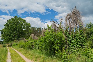
English: Dirt road off Grobbe, a street in Grobba. Grobba is a settlement of Byhleguhre-Byhlen, Landkreis Dahme-Spreewald, Brandenburg, Germany. The road leads to Mühlendorf, another settlement of Byhleguhre-Byhlen.
Deutsch: Feldweg in der Verlängerung der Straße Grobbe in Grobba, einem Gemeindeteil von Byhleguhre-Byhlen, Landkreis Dahme-Spreewald, Brandenburg, Deutschland. Der Feldweg führt nach Mühlendorf, einem weiteren Gemeindeteil von Byhleguhre-Byhlen. Das abgebildete Gelände ist als Bodendenkmal ausgewiesen.
|
||
Date | |||
Source | Own work | ||
Author | J.-H. Janßen |
Camera location | 51° 53′ 02.98″ N, 14° 09′ 52.55″ E | View this and other nearby images on: OpenStreetMap | 51.884160; 14.164597 |
---|
This image was uploaded as part of Wiki Loves Earth 2021.
aragonés ∙ asturianu ∙ azərbaycanca ∙ Bahasa Indonesia ∙ Bahasa Melayu ∙ brezhoneg ∙ català ∙ čeština ∙ Cymraeg ∙ Deutsch ∙ eesti ∙ English ∙ español ∙ euskara ∙ français ∙ galego ∙ hrvatski ∙ italiano ∙ latviešu ∙ Nederlands ∙ norsk ∙ norsk bokmål ∙ português ∙ polski ∙ português do Brasil ∙ română ∙ shqip ∙ sicilianu ∙ slovenščina ∙ svenska ∙ Türkçe ∙ Ελληνικά ∙ беларуская (тарашкевіца) ∙ български ∙ македонски ∙ русский ∙ српски / srpski ∙ українська ∙ ქართული ∙ հայերեն ∙ नेपाली ∙ मराठी ∙ বাংলা ∙ മലയാളം ∙ ไทย ∙ 한국어 ∙ 日本語 ∙ 中文 ∙ 中文(台灣) ∙ 中文(简体) ∙ 中文(繁體) ∙ עברית ∙ اردو ∙ العربية ∙ فارسی ∙ +/− |
Licensing
[edit]- You are free:
- to share – to copy, distribute and transmit the work
- to remix – to adapt the work
- Under the following conditions:
- attribution – You must give appropriate credit, provide a link to the license, and indicate if changes were made. You may do so in any reasonable manner, but not in any way that suggests the licensor endorses you or your use.
- share alike – If you remix, transform, or build upon the material, you must distribute your contributions under the same or compatible license as the original.
File history
Click on a date/time to view the file as it appeared at that time.
Date/Time | Thumbnail | Dimensions | User | Comment | |
---|---|---|---|---|---|
current | 19:28, 4 May 2021 | 5,472 × 3,648 (17.28 MB) | J.-H. Janßen (talk | contribs) | {{Information |Description={{en|1=Dirt road off Grobbe, a street and settlement of Byhleguhre-Byhlen, Landkreis Dahme-Spreewald, Brandenburg, Germany. The road leads to Mühlendorf, another settlement of Byhleguhre-Byhlen.}} {{de|1=Feldweg in der Verlängerung der Straße Grobbe, zugleich ein Gemeindeteil von Byhleguhre-Byhlen, [[:Category:Landkreis Dahme-Spreewald|Landkreis Dahme-Spre... |
You cannot overwrite this file.
File usage on Commons
There are no pages that use this file.
Metadata
This file contains additional information such as Exif metadata which may have been added by the digital camera, scanner, or software program used to create or digitize it. If the file has been modified from its original state, some details such as the timestamp may not fully reflect those of the original file. The timestamp is only as accurate as the clock in the camera, and it may be completely wrong.
Camera manufacturer | Canon |
---|---|
Camera model | Canon EOS 6D |
Author | Jan-Herm Janssen |
Exposure time | 1/125 sec (0.008) |
F-number | f/11 |
ISO speed rating | 100 |
Date and time of data generation | 11:58, 8 June 2020 |
Lens focal length | 28 mm |
Latitude | 51° 53′ 2.98″ N |
Longitude | 14° 9′ 52.55″ E |
Altitude | 51.5 meters above sea level |
Horizontal resolution | 300 dpi |
Vertical resolution | 300 dpi |
Software used | Adobe Photoshop Lightroom 5.7.1 (Windows) |
File change date and time | 10:23, 3 May 2021 |
Exposure Program | Landscape mode (for landscape photos with the background in focus) |
Exif version | 2.3 |
Date and time of digitizing | 11:58, 8 June 2020 |
APEX shutter speed | 6.965784 |
APEX aperture | 6.918863 |
APEX exposure bias | 0 |
Maximum land aperture | 4 APEX (f/4) |
Metering mode | Pattern |
Flash | Flash did not fire, compulsory flash suppression |
DateTimeOriginal subseconds | 00 |
DateTimeDigitized subseconds | 00 |
Color space | sRGB |
Focal plane X resolution | 1,520 |
Focal plane Y resolution | 1,520 |
Focal plane resolution unit | 3 |
Custom image processing | Normal process |
Exposure mode | Auto exposure |
White balance | Manual white balance |
Scene capture type | Standard |
GPS time (atomic clock) | 09:58:18.993 |
Satellites used for measurement | 11 |
Receiver status | Measurement in progress |
Measurement mode | 3-dimensional measurement |
Measurement precision | Poor (50) |
Geodetic survey data used | WGS-84 |
GPS date | 8 June 2020 |
GPS tag version | 0.0.3.2 |
Serial number of camera | 033024001627 |
Lens used | EF24-105mm f/4L IS USM |
Date metadata was last modified | 12:23, 3 May 2021 |
Unique ID of original document | AAA936290691412ACD1FFBA6586CC249 |
IIM version | 4 |
Structured data
Items portrayed in this file
depicts
8 June 2020
51°53'2.976"N, 14°9'52.549"E
0.008 second
11
28 millimetre
100
image/jpeg
a54c6b654b455b78c2975c12bb0f3683c52e3f87
18,120,464 byte
3,648 pixel
5,472 pixel
- Protected areas with known WDPA-ID
- Files with coordinates missing SDC location of creation
- Images from Wiki Loves Earth 2021
- Images from Wiki Loves Earth 2021 in Germany
- Images from Wiki Loves Earth missing SDC depicts
- Images from Wiki Loves Earth missing SDC location of creation
- CC-BY-SA-4.0
- Byhleguhre-Byhlen photographs taken on 2020-06-08
- Taken with Canon EOS 6D and Canon EF 24-105mm F4L IS USM
- Images from Wiki Loves Earth 2021, DE-BB
- Photographs by J.-H. Janßen/Wiki Loves Earth
- Photographs by Jan-Herm Janßen/Byhleguhre-Byhlen
- Images from Wiki Loves Earth 2021, DE landscape