File:By Alrewas Lock, Staffordshire - geograph.org.uk - 1564003.jpg
Jump to navigation
Jump to search

Size of this preview: 436 × 599 pixels. Other resolutions: 175 × 240 pixels | 466 × 640 pixels.
Original file (466 × 640 pixels, file size: 133 KB, MIME type: image/jpeg)
Captions
Captions
Add a one-line explanation of what this file represents
Summary
[edit]
| Description |
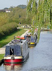
English: By Alrewas Lock, Staffordshire. The picture was taken with telephoto assistance from Gaskell's Bridge (No 46). Alrewas Lock, which lowers the water level to match that of the River Trent is about two hundred metres ahead. The Trent and Mersey Canal follows the river's course for three hundred metres or so below this lock. It is not a good idea to take a boat through when the Trent is in flood. Large warnings signs inform boaters of this. |
| Date | |
| Source | From geograph.org.uk |
| Author | Roger Kidd |
| Attribution (required by the license) | Roger Kidd / By Alrewas Lock, Staffordshire / |
| Camera location | | View this and other nearby images on: OpenStreetMap |
|---|
_heading:45.00&language=en)
| Object location | | View this and other nearby images on: OpenStreetMap |
|---|
_heading:45.00&language=en)
Licensing
[edit]

|
This image was taken from the Geograph project collection. See this photograph's page on the Geograph website for the photographer's contact details. The copyright on this image is owned by Roger Kidd and is licensed for reuse under the Creative Commons Attribution-ShareAlike 2.0 license.
|
This file is licensed under the Creative Commons Attribution-Share Alike 2.0 Generic license.
Attribution: Roger Kidd
- You are free:
- to share – to copy, distribute and transmit the work
- to remix – to adapt the work
- Under the following conditions:
- attribution – You must give appropriate credit, provide a link to the license, and indicate if changes were made. You may do so in any reasonable manner, but not in any way that suggests the licensor endorses you or your use.
- share alike – If you remix, transform, or build upon the material, you must distribute your contributions under the same or compatible license as the original.
File history
Click on a date/time to view the file as it appeared at that time.
| Date/Time | Thumbnail | Dimensions | User | Comment | |
|---|---|---|---|---|---|
| current | 16:20, 3 March 2011 | | 466 × 640 (133 KB) | GeographBot (talk | contribs) | == {{int:filedesc}} == {{Information |description={{en|1=By Alrewas Lock, Staffordshire The picture was taken with telephoto assistance from Gaskell's Bridge (No 46). Alrewas Lock, which lowers the water level to match that of the River Trent is about two |
You cannot overwrite this file.
File usage on Commons
There are no pages that use this file.