File:Bury War Memorial and Parish Church (geograph 4417032).jpg
Jump to navigation
Jump to search

Size of this preview: 400 × 600 pixels. Other resolutions: 160 × 240 pixels | 427 × 640 pixels.
Original file (427 × 640 pixels, file size: 244 KB, MIME type: image/jpeg)
Captions
Captions
Add a one-line explanation of what this file represents
Summary
[edit].jpg&action=edit§ion=1)
| Description |
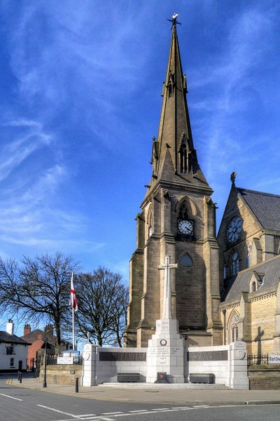
English: Bury War Memorial was unveiled in 1924, by the Earl of Derby. It stands at the corner of Market Place and The Rock outside St Mary's, the Parish Church of Bury. The memorial takes the form of a tall stone cross rising from octagonal base which is flanked by a curving wall on which are two rectangular bronze panels. The panels have compositions comprising a procession of military and civilian figures.
The two end panels carry the inscriptions "PRO REGE" and "PRO PATRIA". The main inscription, in the centre of the memorial reads: 1939 1945 TO THE MEMORY OF THE MEN OF BURY WHO GAVE THEIR LIVES IN THE GREAT WAR 1914 1918 |
| Date | |
| Source | From geograph.org.uk |
| Author | David Dixon |
| Permission (Reusing this file) |
Creative Commons Attribution Share-alike license 2.0 |
| Attribution (required by the license) | David Dixon / Bury War Memorial and Parish Church / |
| Camera location | | View this and other nearby images on: OpenStreetMap |
|---|
.jpg¶ms=053.593585_N_-002.297507_E_globe:Earth_type:camera_source:geograph-osgb36(SD8040610820)_heading:22.00&language=en)
| Object location | | View this and other nearby images on: OpenStreetMap |
|---|
.jpg¶ms=053.593860_N_-002.297300_E_globe:Earth_class:object_type:object_source:geograph-osgb36(SD80421085)_heading:22.00&language=en)
Licensing
[edit].jpg&action=edit§ion=2)

|
This image was taken from the Geograph project collection. See this photograph's page on the Geograph website for the photographer's contact details. The copyright on this image is owned by David Dixon and is licensed for reuse under the Creative Commons Attribution-ShareAlike 2.0 license.
|
This file is licensed under the Creative Commons Attribution-Share Alike 2.0 Generic license.
Attribution: David Dixon
- You are free:
- to share – to copy, distribute and transmit the work
- to remix – to adapt the work
- Under the following conditions:
- attribution – You must give appropriate credit, provide a link to the license, and indicate if changes were made. You may do so in any reasonable manner, but not in any way that suggests the licensor endorses you or your use.
- share alike – If you remix, transform, or build upon the material, you must distribute your contributions under the same or compatible license as the original.
File history
Click on a date/time to view the file as it appeared at that time.
| Date/Time | Thumbnail | Dimensions | User | Comment | |
|---|---|---|---|---|---|
| current | 22:22, 5 February 2023 | | 427 × 640 (244 KB) | Chocolateediter (talk | contribs) | == {{int:filedesc}} == {{Information |Description={{en|1=Bury War Memorial was unveiled in 1924, by the Earl of Derby. It stands at the corner of Market Place and The Rock outside St Mary's, the Parish Church of Bury. The memorial takes the form of a tall stone cross rising from octagonal base which is flanked by a curving wall on which are two rectangular bronze panels. The panels have compositions comprising a procession of military and civilian figures. The two end panels carry the inscri... |
You cannot overwrite this file.
File usage on Commons
There are no pages that use this file.
File usage on other wikis
The following other wikis use this file:
- Usage on en.wikipedia.org
- Usage on sr.wikipedia.org
.jpg&oldid=839503883)