File:Burnt area of the wildfires in Gironde and Landes, France.jpg
Original file (4,007 × 4,057 pixels, file size: 4.61 MB, MIME type: image/jpeg)
Captions
Captions
Summary
[edit]
| Description |
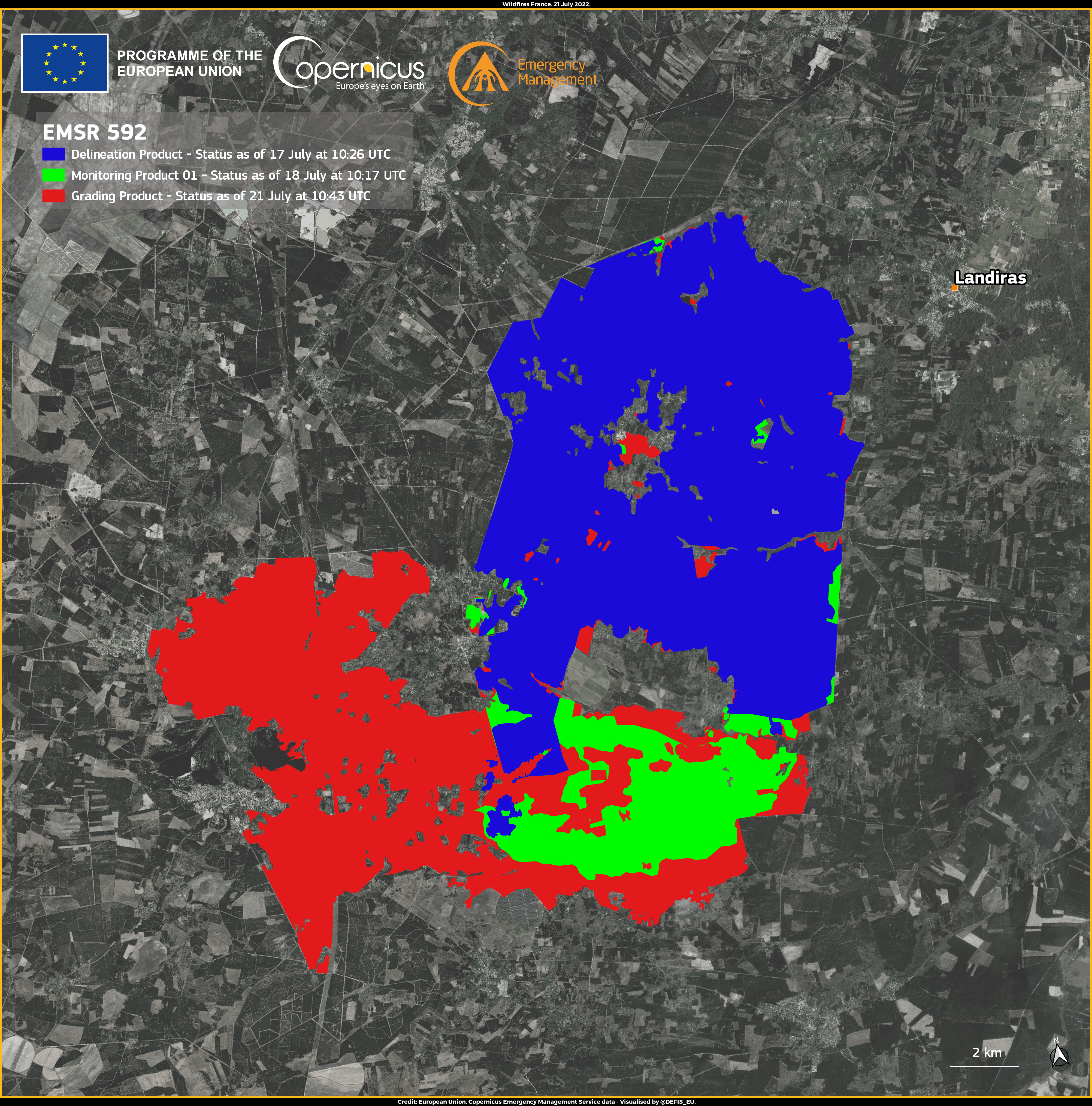
English: On 12 July 2022, two major wildfires broke out in Gironde and Landes, south of Bordeaux in southwestern France. Ten days after their start, the wildfires are not yet completely extinguished. According to the data from the Copernicus Emergency Management Service (CEMS) Rapid Mapping module, which has been activated (EMSR592) by the French authorities and has been assessing the damage caused by the fires, more than 18,000 hectares of land have burnt so far, out of which more than 12,000 hectares In the vicinity of Landiras (as of 21 July 2022 at 10:43). This visualisation, based on CEMS data, shows the evolution of the burnt area close to Landiras on the basis of the three consecutive CEMS Products delivered. |
| Date | Taken in 2022 |
| Source | Burnt area of the wildfires in Gironde and Landes, France |
| Author | European Union, Copernicus Emergency Management Service |
Licensing
[edit]

|
This image contains data from a satellite in the Copernicus Programme, such as Sentinel-1, Sentinel-2 or Sentinel-3. Attribution is required when using this image.
Attribution: Contains modified Copernicus Sentinel data 2022
The use of Copernicus Sentinel Data is regulated under EU law (Commission Delegated Regulation (EU) No 1159/2013 and Regulation (EU) No 377/2014). Relevant excerpts:
Free access shall be given to GMES dedicated data [...] made available through GMES dissemination platforms [...].
Access to GMES dedicated data [...] shall be given for the purpose of the following use in so far as it is lawful:
GMES dedicated data [...] may be used worldwide without limitations in time.
GMES dedicated data and GMES service information are provided to users without any express or implied warranty, including as regards quality and suitability for any purpose. |
File history
Click on a date/time to view the file as it appeared at that time.
| Date/Time | Thumbnail | Dimensions | User | Comment | |
|---|---|---|---|---|---|
| current | 20:55, 17 August 2023 | | 4,007 × 4,057 (4.61 MB) | OptimusPrimeBot (talk | contribs) | #Spacemedia - Upload of https://www.copernicus.eu/system/files/2022-07/image_day/20220723_CEMS_WildfiresFrance.jpg via Commons:Spacemedia |
You cannot overwrite this file.
File usage on Commons
There are no pages that use this file.