File:Burn Scars in Chile (MODIS).jpg

Original file (1,538 × 841 pixels, file size: 202 KB, MIME type: image/jpeg)
Captions
Captions
Summary
[edit].jpg&action=edit§ion=1)
| Description |
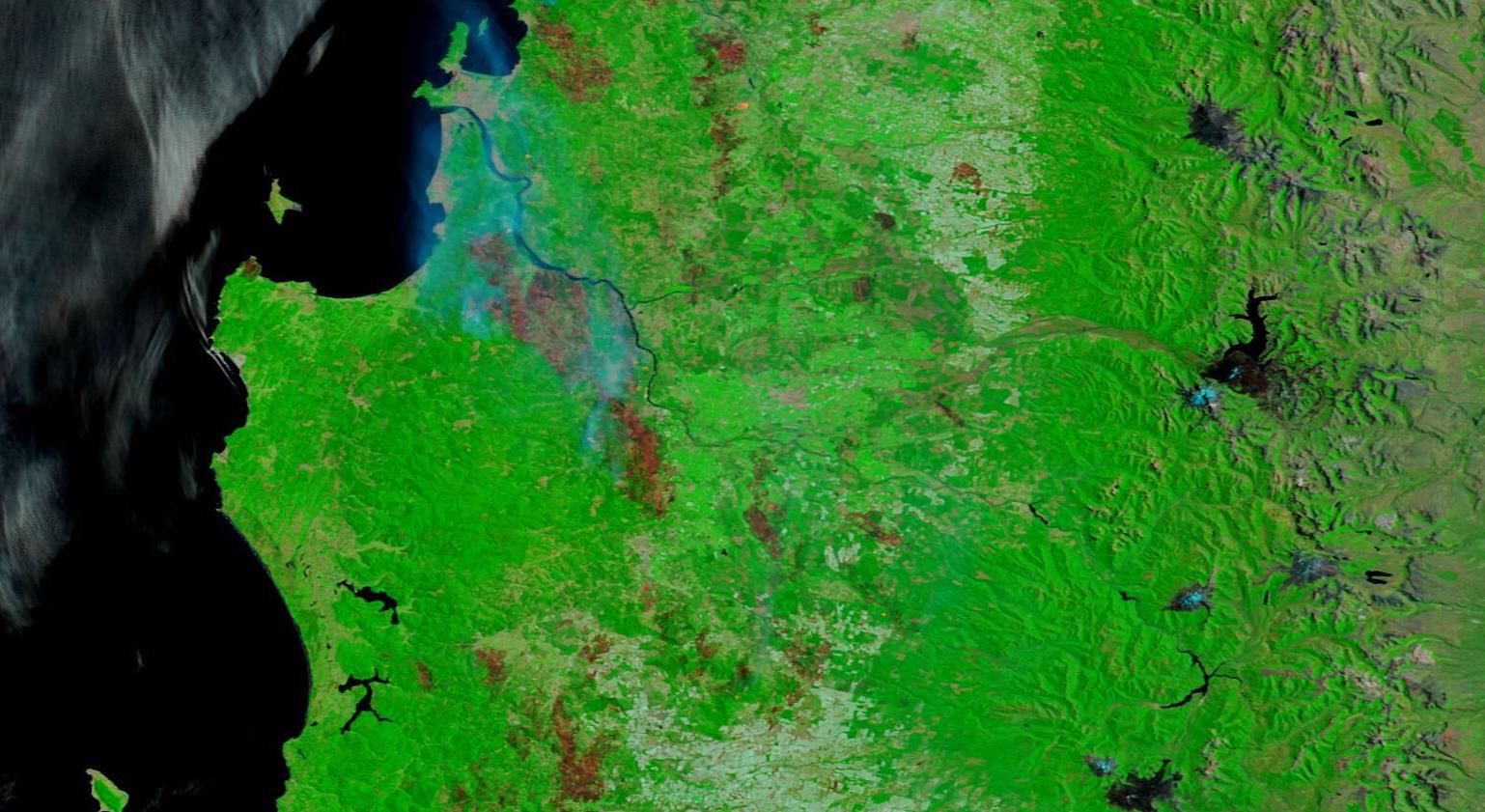
English: Stoked by a summer heat wave and strong winds, widespread fires have been raging through south-central Chile since February 2, 2023. On February 10, ReliefWeb reported that the forest fires have caused extensive damages, including 24 deaths and 5,557 people injured. The report also stated that 1,205 houses had been destroyed and 5,599 houses were damaged as of that date.
On February 11, ABC News said that Chile’s Interior Ministry confirmed that more than 889,000 acres (359,766 hectares) had been burnt so far. The fires are burning mainly in Maule, Ñuble, Biobío, and La Araucanía). The worst fire on record (which goes back to 1985) was in 2017, when 570,000 hectares (1,408,500 acres) burned. On February 9, the Moderate Resolution Imaging Spectroradiometer (MODIS) on board NASA’s Terra satellite acquired a false-color image of massive fire scars in central Chile, south of the Biobío River. This is compared with a Terra MODIS image acquired of the same area on February 2, only a week prior and on the day the wildfire was barely beginning. This type of false-color image combines infrared and visible light (MODIS bands 7,2,1) to separate vegetation (bright green) from water (deep blue or black) and fire scars. Fresh fire scars typically appear brick red, dark brown, or even charcoal depending on the extent of the burn and the color of the exposed soil. Over time, vegetation begins to regrow and the fire scars lighten. The difference in just a week is stunning. On February 2, only a few very light burn scars from previous years were visible. By February 7, numerous fresh burn scars stretched over an extensive area. Smoke (light blue) rises from the largest fire just south of the Biobío River, indicating it is still actively burning. Air temperatures in Chile’s hard hit regions have exceeded 104 degrees Fahrenheit (40° Celsius), helping create tinder-dry vegetation and hindering firefighting efforts. Meanwhile, warm easterly winds blown from Argentina down the slopes of the Andes, also known as “Puelche winds,” contributed to the rapid spread of the fires. Chile is in the midst of a drought, which has lowered reservoirs and caused tensions over water. According to the World Meteorological Organization, the 13-year megadrought in central Chile is the longest in at least 1,000 years. |
||
| Date | Taken on 9 February 2023 | ||
| Source |
Burn Scars in Chile (direct link)
|
||
| Author | MODIS Land Rapid Response Team, NASA GSFC |
| This media is a product of the Terra mission Credit and attribution belongs to the mission team, if not already specified in the "author" row |
Licensing
[edit].jpg&action=edit§ion=2)
| This file is in the public domain in the United States because it was solely created by NASA. NASA copyright policy states that "NASA material is not protected by copyright unless noted". (See Template:PD-USGov, NASA copyright policy page or JPL Image Use Policy.) | ||
 |
Warnings:
|
File history
Click on a date/time to view the file as it appeared at that time.
| Date/Time | Thumbnail | Dimensions | User | Comment | |
|---|---|---|---|---|---|
| current | 20:04, 31 July 2023 | | 1,538 × 841 (202 KB) | OptimusPrimeBot (talk | contribs) | #Spacemedia - Upload of http://modis.gsfc.nasa.gov/gallery/images/image02132023_250m.jpg via Commons:Spacemedia |
You cannot overwrite this file.
File usage on Commons
There are no pages that use this file.
.jpg&oldid=909384807)