File:Burgstall Schweinsberg.png
Jump to navigation
Jump to search

Size of this preview: 800 × 559 pixels. Other resolutions: 320 × 224 pixels | 640 × 447 pixels | 1,024 × 716 pixels | 1,280 × 895 pixels | 2,360 × 1,650 pixels.
Original file (2,360 × 1,650 pixels, file size: 967 KB, MIME type: image/png)
Captions
Captions
Add a one-line explanation of what this file represents
Summary
[edit]
| Description |
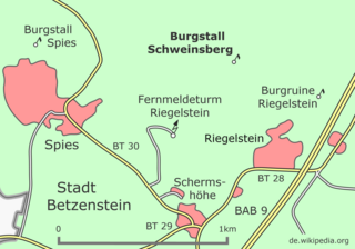
Deutsch: Umgebungskarte des Burgstalls Schweinsberg, fünf Kilometer südlich der Stadt Betzenstein gelegen English: Surrounding map of the former site of the castle of Schweinsberg, located five kilometers south of the town of Betzenstein Français : Carte de l'environnement de l'ancien site du château de Schweinsberg, situé à cinq kilomètres au sud de la ville de Betzenstein |
| Date | |
| Source | Own work |
| Author | Mikmaq |
Licensing
[edit]
I, the copyright holder of this work, hereby publish it under the following license:
This file is licensed under the Creative Commons Attribution 3.0 Unported license.
- You are free:
- to share – to copy, distribute and transmit the work
- to remix – to adapt the work
- Under the following conditions:
- attribution – You must give appropriate credit, provide a link to the license, and indicate if changes were made. You may do so in any reasonable manner, but not in any way that suggests the licensor endorses you or your use.
File history
Click on a date/time to view the file as it appeared at that time.
| Date/Time | Thumbnail | Dimensions | User | Comment | |
|---|---|---|---|---|---|
| current | 21:54, 24 January 2018 | | 2,360 × 1,650 (967 KB) | Mikmaq (talk | contribs) | {{Information |Description= {{de|Umgebungskarte des Burgstalls Schweinsberg, fünf Kilometer südlich der Stadt Betzenstein gelegen}}{{en|Surrounding map of the former site of the castle of Schweinsberg, located five kilometers sout... |
You cannot overwrite this file.
File usage on Commons
The following page uses this file:
File usage on other wikis
The following other wikis use this file:
- Usage on de.wikipedia.org
- Usage on www.wikidata.org