File:Burgerhuis, Ledeberg, Brusselsesteenweg 410.JPG
Jump to navigation
Jump to search

Size of this preview: 450 × 600 pixels. Other resolutions: 180 × 240 pixels | 360 × 480 pixels | 576 × 768 pixels | 768 × 1,024 pixels | 1,536 × 2,048 pixels.
Original file (1,536 × 2,048 pixels, file size: 1.67 MB, MIME type: image/jpeg)
Captions
Captions
Add a one-line explanation of what this file represents
Summary
[edit]
| Description |
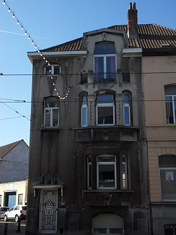
Nederlands: Onderkelderd burgerhuis van het enkelhuistype met twee trav. en drie bouwl., samen met nr. 408 onder een schilddak (n // straat, Vlaamse pannen). Hoogstwaarschijnlijk een XIX Bewoning met ca. 1925 in Art Decostijl aangepaste en gecementeerde lijstgevels n.o.v. architect O. Vandenhoeck (cf. opschrift plintsteen). Bredere venstertrav. met licht erkerachtig uitspringende drielichten. Bovenste deurvenster gemarkeerd door een toog en met decoratieve ijzeren balkonleuningen. Deur met Art Decotraliewerk. Typische behandeling der vensters met gebroken bovendorpel of afgeschuinde bovenhoeken, getrapte rechtstanden, bovenlichten met geometrische houten roedenverdeling en gekleurd glas. Verlevendiging van het gevelvlak door getrapt uit- of verlopende muurvelden al dan niet gecombineerd met ribbel- en driehoekmotieven. Blinde l.zijgevel verticaal geritmeerd door muurdammen.
|
||
| Date | |||
| Source | Own work | ||
| Author | Keplik |
| Camera location | | View this and other nearby images on: OpenStreetMap |
|---|
Licensing
[edit]
I, the copyright holder of this work, hereby publish it under the following license:
This file is licensed under the Creative Commons Attribution-Share Alike 3.0 Unported license.
- You are free:
- to share – to copy, distribute and transmit the work
- to remix – to adapt the work
- Under the following conditions:
- attribution – You must give appropriate credit, provide a link to the license, and indicate if changes were made. You may do so in any reasonable manner, but not in any way that suggests the licensor endorses you or your use.
- share alike – If you remix, transform, or build upon the material, you must distribute your contributions under the same or compatible license as the original.

|
This image was uploaded as part of Wiki Loves Monuments 2012.
|
 |
File history
Click on a date/time to view the file as it appeared at that time.
| Date/Time | Thumbnail | Dimensions | User | Comment | |
|---|---|---|---|---|---|
| current | 13:30, 30 September 2012 | | 1,536 × 2,048 (1.67 MB) | Keplik (talk | contribs) | User created page with UploadWizard |
You cannot overwrite this file.
File usage on Commons
The following page uses this file:
File usage on other wikis
The following other wikis use this file:
- Usage on nl.wikipedia.org