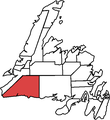
File:Burgeo-La Poile.png
From Wikimedia Commons, the free media repository
Jump to navigation
Jump to search
Burgeo-La_Poile.png (661 × 591 pixels, file size: 18 KB, MIME type: image/png)
File information
Structured data
Captions
Captions
Add a one-line explanation of what this file represents
Summary
[edit]| DescriptionBurgeo-La Poile.png |
Deutsch: Wahlkreis Burgeo-La Poile: Karte basiert auf der Arbeit von Earl Andrew anhand von Karten der Wahl 2007 English: Electoral district of Burgeo-La Poile: Map based on work by Earl Andrew, from maps used in 2007 election Français : Circonscription Burgeo-La Poile: carte basée sur le travail d'Earl Andrew avec des cartes de l'élection de 2007 |
| Date | |
| Source | Own work by the original uploader |
| Author | Griffyn1987 (talk) (Uploads) |
Licensing
[edit]| Public domainPublic domainfalsefalse |
| This work has been released into the public domain by its author, Griffyn1987 at English Wikipedia. This applies worldwide. In some countries this may not be legally possible; if so: Griffyn1987 grants anyone the right to use this work for any purpose, without any conditions, unless such conditions are required by law.Public domainPublic domainfalsefalse |
Original upload log
[edit]The original description page was here. All following user names refer to en.wikipedia.
- 2007-12-13 06:20 Griffyn1987 478×523× (17663 bytes) Map based on work by Earl Andrew, from maps used in 2007 election
File history
Click on a date/time to view the file as it appeared at that time.
| Date/Time | Thumbnail | Dimensions | User | Comment | |
|---|---|---|---|---|---|
| current | 15:27, 5 June 2017 |  | 661 × 591 (18 KB) | Unknownlulz (talk | contribs) | Uses more recent electoral boundaries. |
| 19:26, 24 February 2016 |  | 478 × 523 (17 KB) | DavidMar86hdf (talk | contribs) | User created page with UploadWizard |
You cannot overwrite this file.
File usage on Commons
There are no pages that use this file.
File usage on other wikis
The following other wikis use this file:
- Usage on en.wikipedia.org
- Usage on www.wikidata.org
Metadata
This file contains additional information such as Exif metadata which may have been added by the digital camera, scanner, or software program used to create or digitize it. If the file has been modified from its original state, some details such as the timestamp may not fully reflect those of the original file. The timestamp is only as accurate as the clock in the camera, and it may be completely wrong.
| Horizontal resolution | 37.79 dpc |
|---|---|
| Vertical resolution | 37.79 dpc |
