File:Buntenbock-Luftaufnahme-01.jpg
Jump to navigation
Jump to search

Size of this preview: 800 × 531 pixels. Other resolutions: 320 × 213 pixels | 640 × 425 pixels | 1,024 × 680 pixels | 1,280 × 850 pixels | 2,560 × 1,700 pixels | 3,216 × 2,136 pixels.
Original file (3,216 × 2,136 pixels, file size: 6.71 MB, MIME type: image/jpeg)
Captions
Captions
Add a one-line explanation of what this file represents
Summary
[edit]
| Description |
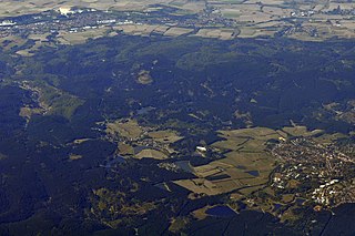
Deutsch: Buntenbock und Clausthal-Zellerfeld, links oben im Bild Osterode, oben Bildmitte Badenhausen, weiter rechts Windhausen. Luftaufnahme aus einem Linienflugzeug.
Folgende Teiche sind erkennbar (von oben und links): hinter Buntenbock Prinzenteich, vor Buntenbock Sumpfteich, Ziegenberger Teich, Bärenbrucher Teich, rechts davon etwas weiter unten Oberer Nassenwieser Teich, neben dem Campingplatz Pixhaier Teich, dahinter Schwarzenbacher Teich, dahinter Hasenbacher Teich, dahinter Semmelwieser Teich, Oberer und Unterer Flambacher Teich, Haderbacher Teich, rechts davon oben im Wald Oberer und Unterer Hahnebalzer Teich, relativ weit rechts daneben oberhalb der Bebauung im Wald Kleiner Clausthaler Teich; in den Feldern links der Bebauung Johann-Friedrich-Teich, Alter Wasserläufer Teich, darunter Hirschler Teich, Oberer, Mittlerer und Unterer Pfauenteich. |
| Date | |
| Source | Own work |
| Author | Kryp |
| Camera location | | View this and other nearby images on: OpenStreetMap |
|---|
Licensing
[edit]
I, the copyright holder of this work, hereby publish it under the following license:
| This file is made available under the Creative Commons CC0 1.0 Universal Public Domain Dedication. | |
| The person who associated a work with this deed has dedicated the work to the public domain by waiving all of their rights to the work worldwide under copyright law, including all related and neighboring rights, to the extent allowed by law. You can copy, modify, distribute and perform the work, even for commercial purposes, all without asking permission.
|
File history
Click on a date/time to view the file as it appeared at that time.
| Date/Time | Thumbnail | Dimensions | User | Comment | |
|---|---|---|---|---|---|
| current | 21:48, 6 October 2018 | | 3,216 × 2,136 (6.71 MB) | Kryp (talk | contribs) | == {{int:filedesc}} == {{Information |Description={{de|Buntenbock und Clausthal-Zellerfeld, links oben im Bild Osterode, oben Bildmitte Badenhausen, weiter rechts Windhausen. Luftaufnahme aus einem Linienflugzeug. Folgende Teiche sind erkennbar (von oben und links): hinter Buntenbock Prinzenteich, vor Buntenbock Sumpfteich, Ziegenberger Teeich, Bärenbrucher Teich, rechts davon etwas weiter unten Oberer Nassenwieser Teich, neben dem Campingplatz Pixhaier Teich, dahinter Schwarzenbacher Teich,... |
You cannot overwrite this file.
File usage on Commons
The following 2 pages use this file:
File usage on other wikis
The following other wikis use this file:
- Usage on it.wikipedia.org