File:Bundesarchiv Bild 183-17761-0008, Berlin, Gebäude der Zentralen Bildstelle.jpg
Jump to navigation
Jump to search
No higher resolution available.
Bundesarchiv_Bild_183-17761-0008,_Berlin,_Gebäude_der_Zentralen_Bildstelle.jpg (783 × 518 pixels, file size: 64 KB, MIME type: image/jpeg)
Captions
Captions
Add a one-line explanation of what this file represents
Summary
[edit]| Berlin, Gebäude der Zentralen Bildstelle
( |
|||||||||||||||||||||||||||
|---|---|---|---|---|---|---|---|---|---|---|---|---|---|---|---|---|---|---|---|---|---|---|---|---|---|---|---|
| Photographer |
Krueger |
||||||||||||||||||||||||||
| Title |
Berlin, Gebäude der Zentralen Bildstelle |
||||||||||||||||||||||||||
| Original caption |
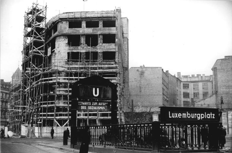
For documentary purposes the German Federal Archive often retained the original image captions, which may be erroneous, biased, obsolete or politically extreme. ADN-ZB-Krueger Heilig-Schm 27.12.1952 Baustelle für das Gebäude der Zentralen Bildstelle (Aufnahme vom 23.12.1952) UBz.: Blick auf die Fassade von der Wilhelm Pieck Strasse aus gesehen. |
||||||||||||||||||||||||||
| Depicted place | Berlin | ||||||||||||||||||||||||||
| Date | 23 December 1952 | ||||||||||||||||||||||||||
| Collection |
|
||||||||||||||||||||||||||
| Current location |
Allgemeiner Deutscher Nachrichtendienst - Zentralbild (Bild 183) |
||||||||||||||||||||||||||
| Accession number | |||||||||||||||||||||||||||
| Source |
|
||||||||||||||||||||||||||

Licensing
[edit]
This file is licensed under the Creative Commons Attribution-Share Alike 3.0 Germany license.
Attribution: Bundesarchiv, Bild 183-17761-0008 / Krueger / CC-BY-SA 3.0
- You are free:
- to share – to copy, distribute and transmit the work
- to remix – to adapt the work
- Under the following conditions:
- attribution – You must give appropriate credit, provide a link to the license, and indicate if changes were made. You may do so in any reasonable manner, but not in any way that suggests the licensor endorses you or your use.
- share alike – If you remix, transform, or build upon the material, you must distribute your contributions under the same or compatible license as the original.

| Camera location | | View this and other nearby images on: OpenStreetMap |
|---|
| Object location | | View this and other nearby images on: OpenStreetMap |
|---|
File history
Click on a date/time to view the file as it appeared at that time.
| Date/Time | Thumbnail | Dimensions | User | Comment | |
|---|---|---|---|---|---|
| current | 07:48, 24 May 2019 | | 783 × 518 (64 KB) | Loominade (talk | contribs) | Cropped 2 % horizontally, 9 % vertically using CropTool with lossless mode. |
| 16:51, 9 December 2008 |  | 800 × 571 (69 KB) | BArchBot (talk | contribs) | == {{int:filedesc}} == {{Information |Description={{BArch-description |comment= <!-- add translations and/or more description --> |biased=<!-- if the original description text is biased, write here why! --> |headline='''Berlin, Gebäude der Zentralen Bild |
You cannot overwrite this file.
File usage on Commons
The following 4 pages use this file: