File:Bunbeg Harbour Road - Derelict buildings - geograph.org.uk - 1176546.jpg
Jump to navigation
Jump to search
No higher resolution available.
Bunbeg_Harbour_Road_-_Derelict_buildings_-_geograph.org.uk_-_1176546.jpg (639 × 426 pixels, file size: 161 KB, MIME type: image/jpeg)
Captions
Captions
Add a one-line explanation of what this file represents
Summary
[edit]
| Description |
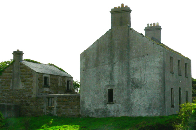
English: Bunbeg Harbour Road - Derelict buildings I parked the car across from these derelict buildings and got out to get a better look at the two buildings. The house had no roof,no second floor, and no doors & windows. The first floor was literally the ground floor, as there was an abundance of plant life growing inside. And there were sizable cracks in the front wall. The owner showed up and I asked what he intended to do with it. He said he intended to repair it. I asked when he expected to complete the repairs. He said come back in about 3 years. I took this photo in 2005. |
| Date | |
| Source | From geograph.org.uk |
| Author | Joseph Mischyshyn |
| Attribution (required by the license) | Joseph Mischyshyn / Bunbeg Harbour Road - Derelict buildings / |
| Camera location | | View this and other nearby images on: OpenStreetMap |
|---|
_heading:180.00&language=en)
| Object location | | View this and other nearby images on: OpenStreetMap |
|---|
_heading:180.00&language=en)
Licensing
[edit]

|
This image was taken from the Geograph project collection. See this photograph's page on the Geograph website for the photographer's contact details. The copyright on this image is owned by Joseph Mischyshyn and is licensed for reuse under the Creative Commons Attribution-ShareAlike 2.0 license.
|
This file is licensed under the Creative Commons Attribution-Share Alike 2.0 Generic license.
Attribution: Joseph Mischyshyn
- You are free:
- to share – to copy, distribute and transmit the work
- to remix – to adapt the work
- Under the following conditions:
- attribution – You must give appropriate credit, provide a link to the license, and indicate if changes were made. You may do so in any reasonable manner, but not in any way that suggests the licensor endorses you or your use.
- share alike – If you remix, transform, or build upon the material, you must distribute your contributions under the same or compatible license as the original.
File history
Click on a date/time to view the file as it appeared at that time.
| Date/Time | Thumbnail | Dimensions | User | Comment | |
|---|---|---|---|---|---|
| current | 16:48, 25 February 2011 | | 639 × 426 (161 KB) | GeographBot (talk | contribs) | == {{int:filedesc}} == {{Information |description={{en|1=Bunbeg Harbour Road - Derelict buildings I parked the car across from these derelict buildings and got out to get a better look at the two buildings. The house had no roof,no second floor, and no do |
You cannot overwrite this file.
File usage on Commons
There are no pages that use this file.