File:BullBottoms-11.22 09.JPG

Original file (1,024 × 768 pixels, file size: 311 KB, MIME type: image/jpeg)
Captions
Captions
Summary
[edit]
| Description |
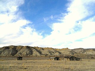
English: Homestead Buildings, Bull Creek Bottoms, Missouri Breaks, Montana |
| Date | |
| Source | own, all rights released |
| Author | montana geographical society |
| Permission (Reusing this file) |
Permission is granted to copy, distribute and/or modify this document under the terms of the GNU Free Documentation License, |
The three buildings are remnants of homestead buildings at Bull Creek Bottom, adjacent to Cow Creek Bottom in the Missouri Breaks of Montana. Bull Creek Bottom is about 21 to 22 miles above the Fred Robinson Bridge on the Missouri, (where U.S. Highway 161 crosses the Missouri River in the breaks)and about 25 miles northeast of Winifred, MT. The view is looking south down to the mouth of Bull Creek, toward the Missouri River which runs along the base of the bluffs in the distance. Cow Island is located at this point in the Missouri. The homestead is located in an isolated remote portion of the Missouri Breaks in Montana. The breaks are so named because of the rough badland-type terrain extending out on either side of the Missouri River for over a hundred miles. The area is mostly traversed by dirt roads which literally become impassible when wet, because the soil in this area contain bentonite which causes mud to cake up around the wheels of any vehicle.
Licensing
[edit]
| I, the copyright holder of this work, release this work into the public domain. This applies worldwide. In some countries this may not be legally possible; if so: I grant anyone the right to use this work for any purpose, without any conditions, unless such conditions are required by law. |
File history
Click on a date/time to view the file as it appeared at that time.
| Date/Time | Thumbnail | Dimensions | User | Comment | |
|---|---|---|---|---|---|
| current | 07:57, 18 April 2024 | | 1,024 × 768 (311 KB) | Beao (talk | contribs) | Removed watermark |
| 23:05, 6 February 2011 |  | 1,024 × 768 (184 KB) | NoAmGeogSoc (talk | contribs) | {{Information |Description ={{en|1=Homestead Buildings, Bull Creek Bottoms, Missouri Breaks, Montana}} |Source =own, all rights released |Author =montana geogaphical society |Date =2009-11-22 |Permission =Permission is gra |
You cannot overwrite this file.
File usage on Commons
There are no pages that use this file.
File usage on other wikis
The following other wikis use this file:
- Usage on en.wikipedia.org
- Usage on zh.wikipedia.org