File:Bulgaria Highways.png
Jump to navigation
Jump to search

Size of this preview: 800 × 533 pixels. Other resolutions: 320 × 213 pixels | 640 × 427 pixels | 1,024 × 683 pixels | 1,200 × 800 pixels.
Original file (1,200 × 800 pixels, file size: 412 KB, MIME type: image/png)
Captions
Captions
Add a one-line explanation of what this file represents
Summary
[edit]
| Description |
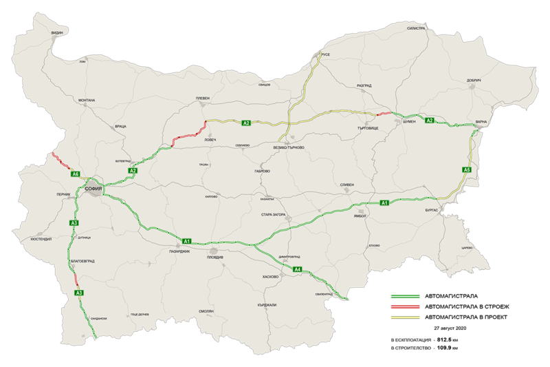
Български: Автомагистрали в България
English: Highways in Bulgaria:
existing
under construction
planned |
| Date | |
| Source | Own work |
| Author | delineator |
| Other versions | Derivative works of this file: Bulgaria Highways-2.png |
Licensing
[edit]
I, the copyright holder of this work, hereby publish it under the following licenses:

|
Permission is granted to copy, distribute and/or modify this document under the terms of the GNU Free Documentation License, Version 1.2 or any later version published by the Free Software Foundation; with no Invariant Sections, no Front-Cover Texts, and no Back-Cover Texts. A copy of the license is included in the section entitled GNU Free Documentation License. |
This file is licensed under the Creative Commons Attribution-Share Alike 3.0 Unported license.
- You are free:
- to share – to copy, distribute and transmit the work
- to remix – to adapt the work
- Under the following conditions:
- attribution – You must give appropriate credit, provide a link to the license, and indicate if changes were made. You may do so in any reasonable manner, but not in any way that suggests the licensor endorses you or your use.
- share alike – If you remix, transform, or build upon the material, you must distribute your contributions under the same or compatible license as the original.
You may select the license of your choice.
File history
Click on a date/time to view the file as it appeared at that time.
| Date/Time | Thumbnail | Dimensions | User | Comment | |
|---|---|---|---|---|---|
| current | 08:22, 27 August 2020 | | 1,200 × 800 (412 KB) | Delineator (talk | contribs) | A2 construction update |
| 20:07, 13 October 2019 |  | 1,200 × 800 (402 KB) | Nexus5219 (talk | contribs) | Sofia East Ring Road update. | |
| 10:52, 13 October 2019 |  | 1,200 × 800 (402 KB) | Nexus5219 (talk | contribs) | А2 update. | |
| 08:11, 28 May 2019 |  | 1,200 × 800 (411 KB) | Delineator (talk | contribs) | A2, A3 and A6 updates | |
| 11:07, 22 January 2019 |  | 1,200 × 800 (413 KB) | Delineator (talk | contribs) | A3 new 24 km from Kresna to Sandanski | |
| 09:02, 29 May 2018 |  | 1,200 × 800 (412 KB) | Delineator (talk | contribs) | New construction segments | |
| 12:31, 12 October 2016 |  | 1,200 × 800 (412 KB) | Delineator (talk | contribs) | Struma Lot 3.3 Under Construction | |
| 11:28, 30 May 2016 |  | 1,200 × 800 (413 KB) | Delineator (talk | contribs) | Sofia North Tangent Completed | |
| 08:05, 29 October 2015 |  | 1,200 × 800 (338 KB) | Delineator (talk | contribs) | Struma Highway Lot2 added, Maritsa Highway Lot1 added | |
| 07:02, 12 September 2015 |  | 1,200 × 800 (338 KB) | Delineator (talk | contribs) | Sandasnki-Kulata added |
You cannot overwrite this file.
File usage on Commons
The following 27 pages use this file:
- User:Chumwa/OgreBot/Potential transport maps/2016 May 21-31
- User:Chumwa/OgreBot/Potential transport maps/2016 October 11-20
- User:Chumwa/OgreBot/Potential transport maps/2018 May 21-31
- User:Chumwa/OgreBot/Potential transport maps/2019 January 21-31
- User:Chumwa/OgreBot/Potential transport maps/2019 May 21-31
- User:Chumwa/OgreBot/Potential transport maps/2019 October 11-20
- User:Chumwa/OgreBot/Transport Maps/2015 August 1-10
- User:Chumwa/OgreBot/Transport Maps/2015 June 1-10
- User:Chumwa/OgreBot/Transport Maps/2015 March 21-31
- User:Chumwa/OgreBot/Transport Maps/2015 October 21-31
- User:Chumwa/OgreBot/Transport Maps/2015 September 11-20
- User:Chumwa/OgreBot/Transport Maps/2016 May 21-31
- User:Chumwa/OgreBot/Transport Maps/2016 October 11-20
- User:Chumwa/OgreBot/Transport Maps/2018 May 21-31
- User:Chumwa/OgreBot/Transport Maps/2019 January 21-31
- User:Chumwa/OgreBot/Transport Maps/2019 May 21-31
- User:Chumwa/OgreBot/Transport Maps/2019 October 11-20
- User:Chumwa/OgreBot/Transport Maps/2020 August 21-31
- User:Chumwa/OgreBot/Travel and communication maps/2016 May 21-31
- User:Chumwa/OgreBot/Travel and communication maps/2016 October 11-20
- User:Chumwa/OgreBot/Travel and communication maps/2018 May 21-31
- User:Chumwa/OgreBot/Travel and communication maps/2019 January 21-31
- User:Chumwa/OgreBot/Travel and communication maps/2019 May 21-31
- User:Chumwa/OgreBot/Travel and communication maps/2019 October 11-20
- User:Chumwa/OgreBot/Travel and communication maps/2020 August 21-31
- Commons:Files used on the AARoads Wiki/9
- File:Bulgaria Highways-2.png
File usage on other wikis
The following other wikis use this file:
- Usage on bg.wikipedia.org
- Usage on en.wikipedia.org
- Usage on it.wikipedia.org
- Usage on mk.wikipedia.org
- Usage on ro.wikipedia.org
- Usage on ru.wikipedia.org
- Usage on sq.wikipedia.org
- Usage on sv.wikipedia.org
- Usage on tr.wikipedia.org
- Usage on uk.wikipedia.org