File:Bui, Tengah and Kaimear (Landsat).JPG
Jump to navigation
Jump to search
No higher resolution available.
Bui,_Tengah_and_Kaimear_(Landsat).JPG (276 × 345 pixels, file size: 18 KB, MIME type: image/jpeg)
Captions
Captions
Add a one-line explanation of what this file represents
Summary
[edit].JPG&action=edit§ion=1)
| Description |
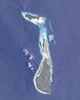
English: This image (Landsat 7) shows a northwestern subgroup of the Kei (Kai) Islands, Indonesia. Shown on the image are the following islands (from north to south): Bui, Tengah and Kaimear, only the last one is inhabited. |
| Date | |
| Source | http://oceancolor.gsfc.nasa.gov/cgi/landsat_extract.pl?path=106&row=64&x=356&y=-2419&n=0&t=321 |
| Author | NASA |
Licensing
[edit].JPG&action=edit§ion=2)
| This file is in the public domain in the United States because it was solely created by NASA. NASA copyright policy states that "NASA material is not protected by copyright unless noted". (See Template:PD-USGov, NASA copyright policy page or JPL Image Use Policy.) | ||
 |
Warnings:
|
File history
Click on a date/time to view the file as it appeared at that time.
| Date/Time | Thumbnail | Dimensions | User | Comment | |
|---|---|---|---|---|---|
| current | 12:41, 19 May 2013 | | 276 × 345 (18 KB) | Wurfzoll (talk | contribs) | User created page with UploadWizard |
You cannot overwrite this file.
File usage on Commons
The following page uses this file:
.JPG&oldid=836900464)