File:Bruno-Möhring-Straße 14B.jpg
Original file (2,066 × 2,961 pixels, file size: 1.85 MB, MIME type: image/jpeg)
Captions
Summary
[edit]DescriptionBruno-Möhring-Straße 14B.jpg |
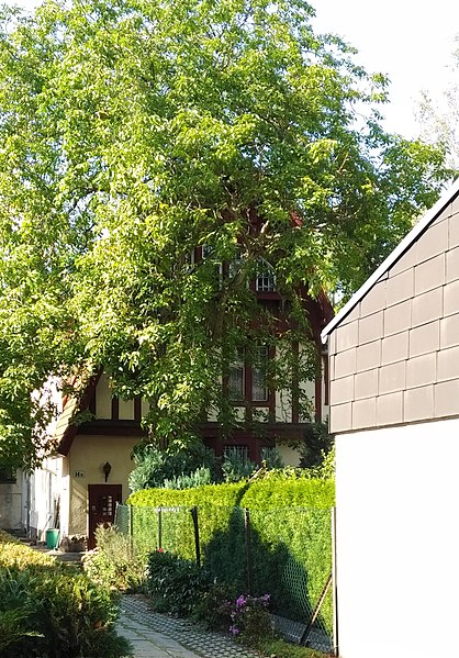
Deutsch: Sommerhaus von Bruno Möhring, 1904 erbaut. Das Grundstück wurde später geteilt und zur Straßenseite ein weiteres Haus (Bezeichnung 14A) errichtet, welches das Sommerhaus fast vollständig verdeckt. An 14 A wurde eine Gedenkplakette angebracht, die an Bruno Möhring erinnert. This is a photograph of an architectural monument. It is on the list of cultural monuments of Berlin, no. 09075153. |
Date | |
Source | Own work |
Author | Vicus valens |
Camera location | 52° 25′ 24.83″ N, 13° 22′ 09.72″ E | View this and other nearby images on: OpenStreetMap | 52.423564; 13.369367 |
---|
Ansicht von der Straßenseite. Zugang zum Objekt lediglich über das Privatgrundstück 14A möglich. Wird von allen Seiten von anderen Häusern vollständig verdeckt.
Licensing
[edit]- You are free:
- to share – to copy, distribute and transmit the work
- to remix – to adapt the work
- Under the following conditions:
- attribution – You must give appropriate credit, provide a link to the license, and indicate if changes were made. You may do so in any reasonable manner, but not in any way that suggests the licensor endorses you or your use.
- share alike – If you remix, transform, or build upon the material, you must distribute your contributions under the same or compatible license as the original.
This image was uploaded as part of Wiki Loves Monuments 2019.
Afrikaans ∙ Alemannisch ∙ العربية ∙ جازايرية ∙ azərbaycanca ∙ Bikol Central ∙ беларуская ∙ беларуская (тарашкевіца) ∙ български ∙ বাংলা ∙ brezhoneg ∙ bosanski ∙ català ∙ čeština ∙ Cymraeg ∙ dansk ∙ Deutsch ∙ Zazaki ∙ Ελληνικά ∙ English ∙ Esperanto ∙ español ∙ eesti ∙ euskara ∙ فارسی ∙ suomi ∙ français ∙ Frysk ∙ Gaeilge ∙ galego ∙ עברית ∙ हिन्दी ∙ hrvatski ∙ magyar ∙ հայերեն ∙ Bahasa Indonesia ∙ Ido ∙ italiano ∙ 日本語 ∙ ქართული ∙ 한국어 ∙ кыргызча ∙ Lëtzebuergesch ∙ latviešu ∙ Malagasy ∙ македонски ∙ മലയാളം ∙ Bahasa Melayu ∙ Malti ∙ norsk bokmål ∙ नेपाली ∙ Nederlands ∙ norsk nynorsk ∙ norsk ∙ polski ∙ português ∙ português do Brasil ∙ română ∙ русский ∙ sicilianu ∙ davvisámegiella ∙ slovenčina ∙ slovenščina ∙ shqip ∙ српски / srpski ∙ svenska ∙ ไทย ∙ Tagalog ∙ Türkçe ∙ українська ∙ اردو ∙ oʻzbekcha / ўзбекча ∙ Yorùbá ∙ 中文 ∙ 中文(中国大陆) ∙ 中文(简体) ∙ 中文(繁體) ∙ 中文(香港) ∙ 中文(臺灣) ∙ +/− |
File history
Click on a date/time to view the file as it appeared at that time.
Date/Time | Thumbnail | Dimensions | User | Comment | |
---|---|---|---|---|---|
current | 13:16, 12 September 2019 | 2,066 × 2,961 (1.85 MB) | Vicus valens (talk | contribs) | User created page with UploadWizard |
You cannot overwrite this file.
File usage on Commons
There are no pages that use this file.
File usage on other wikis
The following other wikis use this file:
- Usage on de.wikipedia.org
Metadata
This file contains additional information such as Exif metadata which may have been added by the digital camera, scanner, or software program used to create or digitize it. If the file has been modified from its original state, some details such as the timestamp may not fully reflect those of the original file. The timestamp is only as accurate as the clock in the camera, and it may be completely wrong.
Camera manufacturer | QCOM-AA |
---|---|
Camera model | QCAM-AA |
Exposure time | 1/286 sec (0.0034965034965035) |
F-number | f/2 |
ISO speed rating | 100 |
Date and time of data generation | 14:13, 11 September 2019 |
Lens focal length | 4.52 mm |
Latitude | 52° 25′ 24.83″ N |
Longitude | 13° 22′ 9.72″ E |
Altitude | 86 meters above sea level |
Orientation | Normal |
Horizontal resolution | 72 dpi |
Vertical resolution | 72 dpi |
Software used | Windows Photo Editor 10.0.10011.16384 |
File change date and time | 14:38, 12 September 2019 |
Y and C positioning | Centered |
Exposure Program | Normal program |
Exif version | 2.2 |
Date and time of digitizing | 14:13, 11 September 2019 |
Meaning of each component |
|
APEX shutter speed | 8.162 |
APEX aperture | 2 |
APEX brightness | 5.11 |
Metering mode | Center weighted average |
Flash | Flash did not fire, auto mode |
DateTime subseconds | 480762 |
DateTimeOriginal subseconds | 480762 |
DateTimeDigitized subseconds | 480762 |
Supported Flashpix version | 1 |
Color space | sRGB |
Sensing method | One-chip color area sensor |
Scene type | A directly photographed image |
Exposure mode | Auto exposure |
White balance | Auto white balance |
Focal length in 35 mm film | 25 mm |
Scene capture type | Standard |
GPS time (atomic clock) | 12:12 |
GPS date | 11 September 2019 |
Structured data
Items portrayed in this file
depicts
52°25'24.830"N, 13°22'9.721"E
11 September 2019
0.0034965034965034965 second
4.52 millimetre
100
image/jpeg
107ed725b54564344c6d565972e4556bc6f62987
1,935,859 byte
2,961 pixel
2,066 pixel
- Files with coordinates missing SDC location of creation
- CC-BY-SA-4.0
- Self-published work
- Images from Wiki Loves Monuments 2019
- Images from Wiki Loves Monuments 2019 in Germany
- Images from Wiki Loves Monuments missing SDC depicts
- Images from Wiki Loves Monuments missing SDC location of creation
- Images from Wiki Loves Monuments 2019, DE-BE
- Images from Wiki Loves Monuments 2019 in Germany not for prejury
- Uploaded via Campaign:wlm-de-be