File:Brungershausen-Burgstall.png
Jump to navigation
Jump to search

Size of this preview: 749 × 599 pixels. Other resolutions: 300 × 240 pixels | 600 × 480 pixels | 960 × 768 pixels | 1,280 × 1,024 pixels | 1,442 × 1,154 pixels.
Original file (1,442 × 1,154 pixels, file size: 453 KB, MIME type: image/png)
Captions
Captions
Add a one-line explanation of what this file represents
Summary
[edit]
| Description |
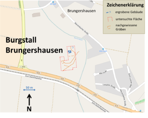
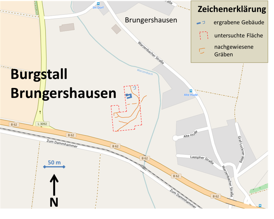
Deutsch: Lage und Ausgrabungsergebnisse des Burgstalls Brungershausen; Kartenmaterial: Open Street Map; Zeichnung selbst erstellt nach den Untersuchungsergebnissen in Bernhard Schroth: Interdisziplinäre Burgenforschung in Marburg, In: Deutsche Gesellschaft für Ur- und Frühgeschichte [DGUF] (Hrsg.): Archäologische Informationen. 19 1/2. Dr. Rudolph Habelt Verlag, Bonn 1996, S. 205–206 |
| Date | |
| Source | Own work |
| Author | Commander-pirx |
Licensing
[edit]
Commander-pirx at German Wikipedia, the copyright holder of this work, hereby publishes it under the following licenses:
This file is licensed under the Creative Commons Attribution-Share Alike 4.0 International license.
Attribution: Commander-pirx at German Wikipedia
- You are free:
- to share – to copy, distribute and transmit the work
- to remix – to adapt the work
- Under the following conditions:
- attribution – You must give appropriate credit, provide a link to the license, and indicate if changes were made. You may do so in any reasonable manner, but not in any way that suggests the licensor endorses you or your use.
- share alike – If you remix, transform, or build upon the material, you must distribute your contributions under the same or compatible license as the original.
This file is licensed under the Creative Commons Attribution-Share Alike 3.0 Germany license.
Attribution: Commander-pirx at German Wikipedia
- You are free:
- to share – to copy, distribute and transmit the work
- to remix – to adapt the work
- Under the following conditions:
- attribution – You must give appropriate credit, provide a link to the license, and indicate if changes were made. You may do so in any reasonable manner, but not in any way that suggests the licensor endorses you or your use.
- share alike – If you remix, transform, or build upon the material, you must distribute your contributions under the same or compatible license as the original.


|
Permission is granted to copy, distribute and/or modify this document under the terms of the GNU Free Documentation License, Version 1.2 or any later version published by the Free Software Foundation; with no Invariant Sections, no Front-Cover Texts, and no Back-Cover Texts. A copy of the license is included in the section entitled GNU Free Documentation License. |
You may select the license of your choice.
| This work contains information from OpenStreetMap, which is made available under the Open Database License (ODbL).
The ODbL does not require any particular license for maps produced from ODbL data. Prior to 1 August 2020, map tiles produced by the OpenStreetMap Foundation were licensed under the CC-BY-SA-2.0 license. Maps produced by other people may be subject to other licences. |
File history
Click on a date/time to view the file as it appeared at that time.
| Date/Time | Thumbnail | Dimensions | User | Comment | |
|---|---|---|---|---|---|
| current | 21:50, 5 October 2016 | | 1,442 × 1,154 (453 KB) | Commander-pirx (talk | contribs) | Rechtschreibfehler korr. |
| 21:43, 5 October 2016 |  | 1,442 × 1,154 (453 KB) | Commander-pirx (talk | contribs) | {{Information |Description ={{de|1=Lage und Ausgrabungsergebnisse des Burgstalls Brungershausen}} |Source ={{own}} |Author =Commander-pirx |Date =2016-10-05 |Permission = |other_versions = }} [[... |
You cannot overwrite this file.
File usage on Commons
The following 2 pages use this file:
File usage on other wikis
The following other wikis use this file:
- Usage on de.wikipedia.org
- Usage on www.wikidata.org