File:Bruce's Mark reef map.png
Jump to navigation
Jump to search

Size of this preview: 800 × 546 pixels. Other resolutions: 320 × 218 pixels | 640 × 437 pixels | 1,024 × 699 pixels | 1,280 × 874 pixels | 2,560 × 1,748 pixels | 8,779 × 5,994 pixels.
Original file (8,779 × 5,994 pixels, file size: 1.46 MB, MIME type: image/png)
Captions
Captions
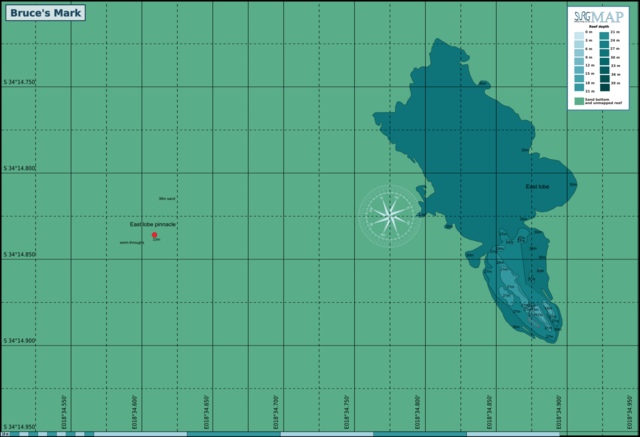
Map of the dive site near Whittle Rock, False Bay
Summary
[edit]
| Description |
English: Bathymetric chart of the dive site at Bruce's Mark near Whittle Rock in False Bay, South Africa |
| Date | |
| Source | Own work |
| Author | Peter Southwood |
Licensing
[edit]
I, the copyright holder of this work, hereby publish it under the following license:
This file is licensed under the Creative Commons Attribution-Share Alike 4.0 International license.
- You are free:
- to share – to copy, distribute and transmit the work
- to remix – to adapt the work
- Under the following conditions:
- attribution – You must give appropriate credit, provide a link to the license, and indicate if changes were made. You may do so in any reasonable manner, but not in any way that suggests the licensor endorses you or your use.
- share alike – If you remix, transform, or build upon the material, you must distribute your contributions under the same or compatible license as the original.
File history
Click on a date/time to view the file as it appeared at that time.
| Date/Time | Thumbnail | Dimensions | User | Comment | |
|---|---|---|---|---|---|
| current | 11:16, 5 May 2024 | | 8,779 × 5,994 (1.46 MB) | Pbsouthwood (talk | contribs) | added more 30m contour to north |
| 18:12, 11 November 2023 |  | 8,779 × 5,994 (1.42 MB) | Pbsouthwood (talk | contribs) | added more 30m contour at northwest | |
| 17:54, 10 August 2022 |  | 8,779 × 5,994 (1.38 MB) | Pbsouthwood (talk | contribs) | marks for the westerm pinnacle | |
| 19:11, 28 April 2022 |  | 5,851 × 5,994 (1.17 MB) | Pbsouthwood (talk | contribs) | added some 24m contours | |
| 10:36, 5 April 2022 |  | 5,851 × 5,994 (1.11 MB) | Pbsouthwood (talk | contribs) | added 21m contour | |
| 19:20, 14 November 2021 |  | 5,851 × 5,994 (1.02 MB) | Pbsouthwood (talk | contribs) | More 30m contour on west side | |
| 12:46, 30 August 2021 |  | 5,851 × 5,994 (994 KB) | Pbsouthwood (talk | contribs) | added partial 30m contour | |
| 18:34, 29 March 2021 |  | 4,866 × 4,214 (798 KB) | Pbsouthwood (talk | contribs) | Uploaded own work with UploadWizard |
You cannot overwrite this file.
File usage on Commons
The following 17 pages use this file:
- User:Adeletron 3030/botgalleries/Sports/2021 November 13-15/Overflow 2
- User:Chumwa/OgreBot/Transport Maps/2021 August 21-31
- User:Chumwa/OgreBot/Transport Maps/2021 March 21-31
- User:Chumwa/OgreBot/Transport Maps/2021 November 11-20
- User:Chumwa/OgreBot/Transport Maps/2022 April 1-10
- User:Chumwa/OgreBot/Transport Maps/2022 April 21-30
- User:Chumwa/OgreBot/Transport Maps/2022 August 1-10
- User:Chumwa/OgreBot/Transport Maps/2023 November 11-20
- User:Chumwa/OgreBot/Transport Maps/2024 May 1-10
- User:Chumwa/OgreBot/Travel and communication maps/2021 August 21-31
- User:Chumwa/OgreBot/Travel and communication maps/2021 March 21-31
- User:Chumwa/OgreBot/Travel and communication maps/2021 November 11-20
- User:Chumwa/OgreBot/Travel and communication maps/2022 April 1-10
- User:Chumwa/OgreBot/Travel and communication maps/2022 April 21-30
- User:Chumwa/OgreBot/Travel and communication maps/2022 August 1-10
- User:Chumwa/OgreBot/Travel and communication maps/2023 November 11-20
- User:Chumwa/OgreBot/Travel and communication maps/2024 May 1-10
File usage on other wikis
The following other wikis use this file:
- Usage on en.wikivoyage.org