File:Bronze age developed flat axe (FindID 462647).jpg

Original file (6,221 × 5,048 pixels, file size: 1.78 MB, MIME type: image/jpeg)
Captions
Captions
Summary
[edit].jpg&action=edit§ion=1)
| Bronze age developed flat axe | |||
|---|---|---|---|
| Photographer |
Lincolnshire County Council, Adam Daubney, 2011-09-15 15:14:04 |
||
| Title |
Bronze age developed flat axe |
||
| Description |
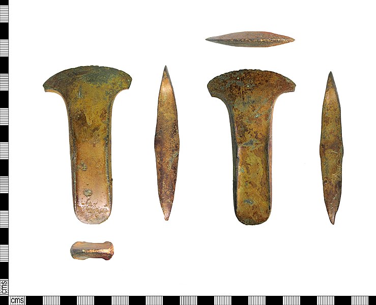
English: A cast copper-alloy developed flat axehead of Middle Bronze Age date (c.2000 BC -c.1700 BC ) which corresponds to Needham's (1996) Period 3.
The blade end is crescentic in form, flaring to either side of the axe, the cutting edge is damaged in places but otherwise is in good condition. It has a flat, rectangular body that gradually tapers towards the butt end. Half way along the axe on either side is a shallow stop-ridge that seem to be early forms of the more prominant versions seen on palstaves. The axe has a brownish patina; the surface is smooth and in good condition. The axe is probably an Aylesford type developed flat axe, dating from 2150-1500 BC. Similar examples can be seen in Moore and Rowlands, plate VI. See also YORYM-0D0388 on this database. |
||
| Depicted place | (County of findspot) Lincolnshire | ||
| Date | between 2000 BC and 1700 BC | ||
| Accession number |
FindID: 462647 Old ref: LIN-207EF7 Filename: LIN2011-906.jpg |
||
| Credit line |
|
||
| Source |
https://finds.org.uk/database/ajax/download/id/346062 Catalog: https://finds.org.uk/database/images/image/id/346062/recordtype/artefacts archive copy at the Wayback Machine Artefact: https://finds.org.uk/database/artefacts/record/id/462647 |
||
| Permission (Reusing this file) |
Attribution-ShareAlike License | ||
| Object location | | View this and other nearby images on: OpenStreetMap |
|---|
.jpg¶ms=053.159500_N_-000.401679_E_globe:Earth_class:object_type:object__&language=en)
Licensing
[edit].jpg&action=edit§ion=2)
- You are free:
- to share – to copy, distribute and transmit the work
- to remix – to adapt the work
- Under the following conditions:
- attribution – You must give appropriate credit, provide a link to the license, and indicate if changes were made. You may do so in any reasonable manner, but not in any way that suggests the licensor endorses you or your use.
- share alike – If you remix, transform, or build upon the material, you must distribute your contributions under the same or compatible license as the original.
File history
Click on a date/time to view the file as it appeared at that time.
| Date/Time | Thumbnail | Dimensions | User | Comment | |
|---|---|---|---|---|---|
| current | 13:46, 4 February 2017 | | 6,221 × 5,048 (1.78 MB) | Fæ (talk | contribs) | Portable Antiquities Scheme, LIN, FindID: 462647, bronze age, page 7560, batch primary count 56482 |
You cannot overwrite this file.
File usage on Commons
The following page uses this file:
.jpg)
.jpg&oldid=835021637)