File:Broadside of maps and views of Admiral Edward Vernon's capture of Portobello, Panama, during the War of Jenkins' Ear 35134 (cropped).jpg
Jump to navigation
Jump to search

Size of this preview: 800 × 430 pixels. Other resolutions: 320 × 172 pixels | 640 × 344 pixels | 1,416 × 761 pixels.
Original file (1,416 × 761 pixels, file size: 1.37 MB, MIME type: image/jpeg)
Captions
Captions
Add a one-line explanation of what this file represents
Summary
[edit]| Description |
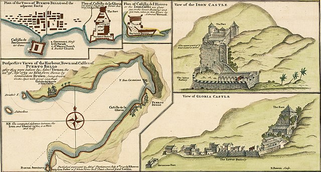
English: Perspective Views of the Harbour, Town and Castles of Puerto Bello (Portobelo), after they were taken by Admiral Vernon the 22nd Nov 1739 as sent from thence by Commodore Brown. Extracted from: A Sequel of the Seat of War in the West Indies containing (1) a Map of the Isthmus of Panama exhibiting the Roads with the Course of the River Châgre thro the same (2) Curious Perspective Views of the Harbour, Town and Castles of Puerto Bello, as sent over by Commodore Brown (3) the Appearance at Sea of San Juan de Puerto Rico with it's Castles / from Admiral Vernon's own draught, the whole illustrated with remarks.
Español: Vistas en perspectiva del puerto, la ciudad y los castillos de Puerto Bello (Portobelo), después de que fueran tomadas por el almirante Vernon el 22 de noviembre de 1739. Tomado de A Sequel of the Seat of War in the West Indies. |
| Date | |
| Source | https://www.raremaps.com/gallery/detail/35134/panama---battle-of-portobello-and-the-war-of-jenkins-ear-bowen |
| Author | Edward Vernon, Emanuel Bowen (1694-1767) |
| Other versions |

.jpg&action=edit§ion=1)
Licensing
[edit].jpg&action=edit§ion=2)
|
This work is in the public domain in its country of origin and other countries and areas where the copyright term is the author's life plus 100 years or fewer. This work is in the public domain in the United States because it was published (or registered with the U.S. Copyright Office) before January 1, 1929. | |
| This file has been identified as being free of known restrictions under copyright law, including all related and neighboring rights. | |
File history
Click on a date/time to view the file as it appeared at that time.
| Date/Time | Thumbnail | Dimensions | User | Comment | |
|---|---|---|---|---|---|
| current | 22:16, 11 April 2022 | | 1,416 × 761 (1.37 MB) | Arjuno3 (talk | contribs) | File:Broadside of maps and views of Admiral Edward Vernon's capture of Portobello, Panama, during the War of Jenkins' Ear 35134.jpg cropped 9 % horizontally, 62 % vertically using CropTool with precise mode. |
You cannot overwrite this file.
File usage on Commons
The following 2 pages use this file:
File usage on other wikis
The following other wikis use this file:
- Usage on de.wikipedia.org
- Usage on es.wikipedia.org
- Usage on fi.wikipedia.org
- Usage on fr.wikipedia.org
.jpg&oldid=834639622)