File:Broadside of maps and views of Admiral Edward Vernon's capture of Portobello, Panama, during the War of Jenkins' Ear 35134.jpg

Original file (1,550 × 1,977 pixels, file size: 3.58 MB, MIME type: image/jpeg)
Captions
Captions
Summary
[edit]| Description |
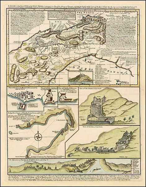
English: A Sequel of the Seat of War in the West Indies containing (1) a Map of the Isthmus of Panama exhibiting the Roads with the Course of the River Châgre thro the same (2) Curious Perspective Views of the Harbour, Town and Castles of Puerto Bello, as sent over by Commodore Brown (3) the Appearance at Sea of San Juan de Puerto Rico with it's Castles / from Admiral Vernon's own draught, the whole illustrated with remarks.
A Map of the Isthmus of Panama exhibiting the Roads with the Course of the River Châgre thro the same Town & Castle of Chagres before it was demolished. Perspective Views of the Harbour, Town and Castles of Puerto Bello, after they were taken by Admiral Vernon the 22nd Nov 1739 as sent from thence by Commodore Brown The Appearance of San Juan de Puerto Rico by Admiral Vernon, from the sea showing it's castles 14 x 18.5 inches |
| Date | |
| Source | https://www.raremaps.com/gallery/detail/35134/panama---battle-of-portobello-and-the-war-of-jenkins-ear-bowen |
| Author | Edward Vernon, Emanuel Bowen (1694-1767) |
| Other versions |
.jpg)
Licensing
[edit]
|
This work is in the public domain in its country of origin and other countries and areas where the copyright term is the author's life plus 100 years or fewer. This work is in the public domain in the United States because it was published (or registered with the U.S. Copyright Office) before January 1, 1929. | |
| This file has been identified as being free of known restrictions under copyright law, including all related and neighboring rights. | |
File history
Click on a date/time to view the file as it appeared at that time.
| Date/Time | Thumbnail | Dimensions | User | Comment | |
|---|---|---|---|---|---|
| current | 13:08, 27 February 2020 | | 1,550 × 1,977 (3.58 MB) | Broichmore (talk | contribs) | User created page with UploadWizard |
You cannot overwrite this file.
File usage on Commons
The following page uses this file:
File usage on other wikis
The following other wikis use this file:
- Usage on ru.wikipedia.org
Metadata
- War of Jenkins' Ear
- Edward Vernon
- Maps by Emanuel Bowen
- Panama in the 18th century
- Castillo del Hierro (Iron Castle)
- Old maps of Portobelo
- Fortifications of Santiago (Portobelo)
- Panama in art
- 18th-century engravings of castles
- 1739-11-22
- 1739 in South America
- Maps of battles
- 18th-century maps of Panama
- Panama in the 1730s