File:Bristenstäfeli 20200207 3.jpg
Jump to navigation
Jump to search

Size of this preview: 800 × 567 pixels. Other resolutions: 320 × 227 pixels | 640 × 454 pixels | 1,024 × 726 pixels | 1,280 × 908 pixels | 2,560 × 1,816 pixels | 5,147 × 3,651 pixels.
Original file (5,147 × 3,651 pixels, file size: 16.58 MB, MIME type: image/jpeg)
Captions
Captions
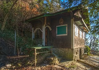
Bristenstäfeli in Fallätsche
Summary
[edit]
| Description |
English: The Bristenstäfeli is a small hut in Fallätsche near Zurich. It is in acute danger of falling down due to erosion. |
| Date | |
| Source | Own work |
| Author | Daniel Kraft |
| Camera location | | View this and other nearby images on: OpenStreetMap |
|---|
| Object location | | View this and other nearby images on: OpenStreetMap |
|---|
Licensing
[edit]
I, the copyright holder of this work, hereby publish it under the following license:
This file is licensed under the Creative Commons Attribution-Share Alike 3.0 Unported license.
- You are free:
- to share – to copy, distribute and transmit the work
- to remix – to adapt the work
- Under the following conditions:
- attribution – You must give appropriate credit, provide a link to the license, and indicate if changes were made. You may do so in any reasonable manner, but not in any way that suggests the licensor endorses you or your use.
- share alike – If you remix, transform, or build upon the material, you must distribute your contributions under the same or compatible license as the original.

|
This image has been assessed under the valued image criteria and is considered the most valued image on Commons within the scope: Bristenstäfeli (Fallätsche). You can see its nomination here. |
File history
Click on a date/time to view the file as it appeared at that time.
| Date/Time | Thumbnail | Dimensions | User | Comment | |
|---|---|---|---|---|---|
| current | 14:11, 8 February 2020 | | 5,147 × 3,651 (16.58 MB) | Domob (talk | contribs) | User created page with UploadWizard |
You cannot overwrite this file.
File usage on Commons
The following 2 pages use this file: