File:Brighton Road, Purley, 1981 - geograph.org.uk - 610561.jpg
Jump to navigation
Jump to search
No higher resolution available.
Brighton_Road,_Purley,_1981_-_geograph.org.uk_-_610561.jpg (640 × 538 pixels, file size: 82 KB, MIME type: image/jpeg)
Captions
Captions
Add a one-line explanation of what this file represents
Summary
[edit]
| Description |
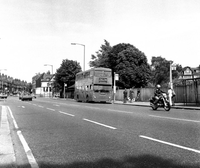
English: Brighton Road, Purley: 1981 Looking north along the A23 we are just south of Purley Cross, (this point was known as Purley Fountain at one time, as a drinking fountain was on the corner).
The DMS class bus is on Route 166 to Chipstead Valley. This bus route still runs but is now extended to Banstead (some journeys to Epsom), and single deckers are used. The view here is quite different now as a mammoth Tesco store occupies the former waterworks grounds to the right. The A23 is dual carriageway and a huge gyratory system has been installed. |
| Date | |
| Source | From geograph.org.uk |
| Author | Dr Neil Clifton |
| Attribution (required by the license) | Dr Neil Clifton / Brighton Road, Purley: 1981 / |
| Camera location | | View this and other nearby images on: OpenStreetMap |
|---|
_heading:67.00&language=en)
| Object location | | View this and other nearby images on: OpenStreetMap |
|---|
_heading:67.00&language=en)
Licensing
[edit]

|
This image was taken from the Geograph project collection. See this photograph's page on the Geograph website for the photographer's contact details. The copyright on this image is owned by Dr Neil Clifton and is licensed for reuse under the Creative Commons Attribution-ShareAlike 2.0 license.
|
This file is licensed under the Creative Commons Attribution-Share Alike 2.0 Generic license.
Attribution: Dr Neil Clifton
- You are free:
- to share – to copy, distribute and transmit the work
- to remix – to adapt the work
- Under the following conditions:
- attribution – You must give appropriate credit, provide a link to the license, and indicate if changes were made. You may do so in any reasonable manner, but not in any way that suggests the licensor endorses you or your use.
- share alike – If you remix, transform, or build upon the material, you must distribute your contributions under the same or compatible license as the original.
File history
Click on a date/time to view the file as it appeared at that time.
| Date/Time | Thumbnail | Dimensions | User | Comment | |
|---|---|---|---|---|---|
| current | 02:04, 7 February 2011 | | 640 × 538 (82 KB) | GeographBot (talk | contribs) | == {{int:filedesc}} == {{Information |description={{en|1=Brighton Road, Purley: 1981 Looking north along the A23 we are just south of Purley Cross, (this point was known as Purley Fountain at one time, as a drinking fountain was on the corner). The DMS c |
You cannot overwrite this file.
File usage on Commons
There are no pages that use this file.