File:Brienz Rothorn Bahn, verbogene Schienen.JPG
Jump to navigation
Jump to search
Size of this preview: 800 × 498 pixels. Other resolutions: 320 × 199 pixels | 640 × 398 pixels | 1,024 × 637 pixels | 1,280 × 796 pixels | 2,063 × 1,283 pixels.
Original file (2,063 × 1,283 pixels, file size: 806 KB, MIME type: image/jpeg)
Captions
Captions
Add a one-line explanation of what this file represents
Summary
[edit]
| Description |
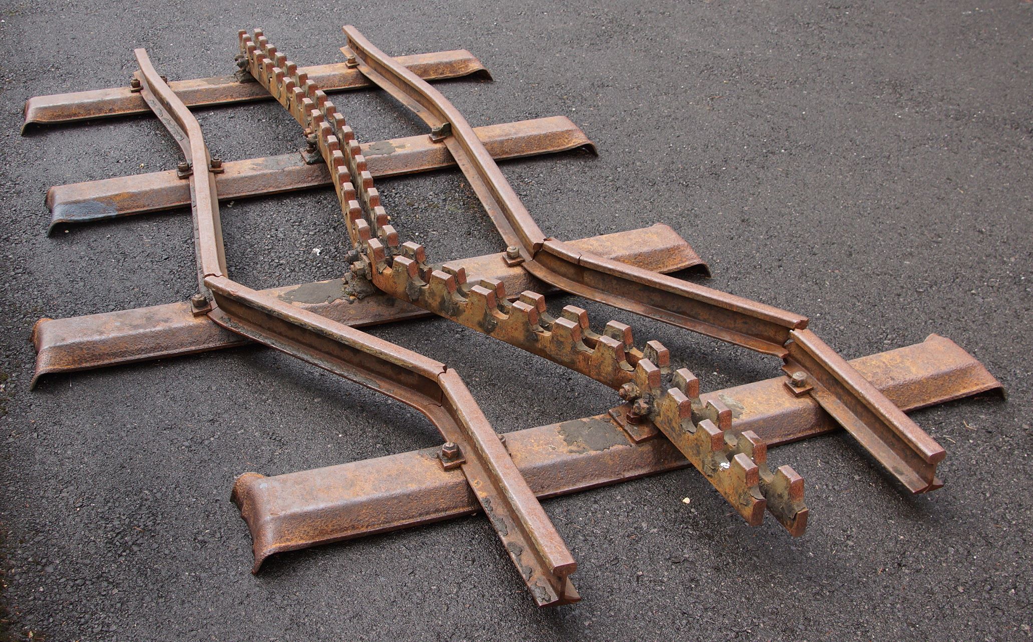
Deutsch: Brienz Rothorn Bahn, verbogene Schienen. Im Winter 2011/2012 lag auf der Brienz Rothornbahn so viel Schnee wie zum letzten Mal 1967. Der Schnee drückte seitlich auf die Schienen des Typs S20 aus dem Jahr 1892. Dadurch brach eine der Schienen und das Gleis musste vor der Saisoneröffnung auf einer Länge von 60 m erneuert werden.
English: Bent rails on display at the Brienz station of the Brienz Rothorn railway. In the winter of 2011/2012, more snow accumulated on the Rothorn than in any year since 1967. At 2000m above sea level the pressure generated by this enormous field of snow was enough to push 60m of the trackwork out of alignment by some 1.5m. This recovered section dating from 1891 shows just how much force was involved. With only 14 days to go until opening for the 2012 season the entire 60m section was replaced and ready for service on time. |
| Date | Taken on 4 August 2015 |
| Source | Own work |
| Author | NearEMPTiness |
| Camera location | | View this and other nearby images on: OpenStreetMap |
|---|
Licensing
[edit]
I, the copyright holder of this work, hereby publish it under the following license:
This file is licensed under the Creative Commons Attribution-Share Alike 4.0 International license.
- You are free:
- to share – to copy, distribute and transmit the work
- to remix – to adapt the work
- Under the following conditions:
- attribution – You must give appropriate credit, provide a link to the license, and indicate if changes were made. You may do so in any reasonable manner, but not in any way that suggests the licensor endorses you or your use.
- share alike – If you remix, transform, or build upon the material, you must distribute your contributions under the same or compatible license as the original.
File history
Click on a date/time to view the file as it appeared at that time.
| Date/Time | Thumbnail | Dimensions | User | Comment | |
|---|---|---|---|---|---|
| current | 10:59, 4 October 2015 | | 2,063 × 1,283 (806 KB) | NearEMPTiness (talk | contribs) | Cropped |
| 15:41, 9 August 2015 |  | 3,008 × 1,688 (3.5 MB) | NearEMPTiness (talk | contribs) | User created page with UploadWizard |
You cannot overwrite this file.
File usage on Commons
There are no pages that use this file.
File usage on other wikis
The following other wikis use this file:
- Usage on de.wikipedia.org