File:Bretz Farm driveway.jpg
Jump to navigation
Jump to search

Size of this preview: 800 × 600 pixels. Other resolutions: 320 × 240 pixels | 640 × 480 pixels | 1,024 × 768 pixels | 1,280 × 960 pixels | 2,560 × 1,920 pixels | 2,816 × 2,112 pixels.
Original file (2,816 × 2,112 pixels, file size: 3.57 MB, MIME type: image/jpeg)
Captions
Captions
Add a one-line explanation of what this file represents
|
This is an image of a place or building that is listed on the National Register of Historic Places in the United States of America. Its reference number is 80003155. |
| Camera location | | View this and other nearby images on: OpenStreetMap |
|---|
| Description |
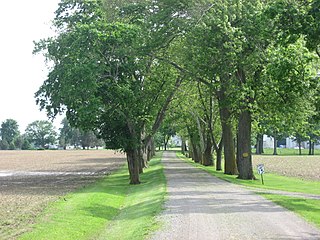
English: Driveway to Bretz Farm, located at 197 Morral-Kirkpatrick Road east of Morral in Grand Prairie Township, Marion County, Ohio, United States. The farm complex is listed on the National Register of Historic Places. |
||
| Date | Taken on 28 May 2011 | ||
| Source | Own work | ||
| Author | Nyttend | ||
| Permission (Reusing this file) |
|
File history
Click on a date/time to view the file as it appeared at that time.
| Date/Time | Thumbnail | Dimensions | User | Comment | |
|---|---|---|---|---|---|
| current | 17:05, 29 May 2011 | | 2,816 × 2,112 (3.57 MB) | Nyttend (talk | contribs) | {{Location|40|41|16|N|84|9|20|W}} {{Information |Description={{en|Driveway to {{w|Bretz Farm}}, located at 197 Morral-Kirkpatrick Road east of {{w|Morral, Ohio|Morral}} in {{w|Grand Prairie Township, Marion County, Ohio|Grand Prairie Township}}, {{w|Mario |
You cannot overwrite this file.
File usage on Commons
There are no pages that use this file.
File usage on other wikis
The following other wikis use this file:
- Usage on en.wikipedia.org
- Usage on es.wikipedia.org
- Usage on eu.wikipedia.org
- Usage on fa.wikipedia.org
- Usage on pt.wikipedia.org
- Usage on vi.wikipedia.org
- Usage on www.wikidata.org
- Usage on zh.wikipedia.org