File:Brenz catchment.png
Jump to navigation
Jump to search

Size of this preview: 662 × 600 pixels. Other resolutions: 265 × 240 pixels | 530 × 480 pixels | 848 × 768 pixels | 1,200 × 1,087 pixels.
Original file (1,200 × 1,087 pixels, file size: 2.59 MB, MIME type: image/png)
Captions
Captions
Add a one-line explanation of what this file represents
Summary
[edit]
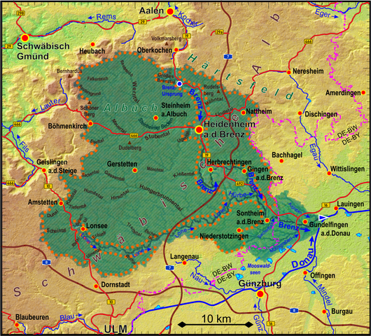
| Description |
Deutsch: Einzugsgebiet der Brenz. Innerhalb der schraffierten Flächen existieren nahezu keine Oberflächenabflüsse. Wichtige Trockentäler sind mit Namen versehen.
English: Catchment area of the Brenz river. Within the hatched areas almost no surface runoffs exist. Major dry valley are labeled. |
| Date | |
| Source | Own work based on ASTER Digital Elevation Model data by https://lpdaac.usgs.gov/ and own runoff calculation |
| Author | Periphrastika |
Licensing
[edit]
I, the copyright holder of this work, hereby publish it under the following license:
This file is licensed under the Creative Commons Attribution-Share Alike 4.0 International license.
- You are free:
- to share – to copy, distribute and transmit the work
- to remix – to adapt the work
- Under the following conditions:
- attribution – You must give appropriate credit, provide a link to the license, and indicate if changes were made. You may do so in any reasonable manner, but not in any way that suggests the licensor endorses you or your use.
- share alike – If you remix, transform, or build upon the material, you must distribute your contributions under the same or compatible license as the original.
File history
Click on a date/time to view the file as it appeared at that time.
| Date/Time | Thumbnail | Dimensions | User | Comment | |
|---|---|---|---|---|---|
| current | 07:54, 1 April 2024 | | 1,200 × 1,087 (2.59 MB) | Periphrastika (talk | contribs) | update |
| 11:53, 22 December 2018 |  | 1,200 × 1,066 (1.4 MB) | Periphrastika (talk | contribs) | User created page with UploadWizard |
You cannot overwrite this file.
File usage on Commons
The following page uses this file:
File usage on other wikis
The following other wikis use this file:
- Usage on de.wikipedia.org
- Usage on nl.wikipedia.org
- Usage on pl.wikipedia.org