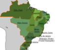
File:Brazil provinces 1825 (edit).PNG
Brazil_provinces_1825_(edit).PNG (435 × 369 pixels, file size: 12 KB, MIME type: image/png)
Captions
Captions

|
This map image could be re-created using vector graphics as an SVG file. This has several advantages; see Commons:Media for cleanup for more information. If an SVG form of this image is available, please upload it and afterwards replace this template with
{{vector version available|new image name}}.
It is recommended to name the SVG file “Brazil provinces 1825 (edit).svg”—then the template Vector version available (or Vva) does not need the new image name parameter. |
Summary
[edit]| DescriptionBrazil provinces 1825 (edit).PNG |
English: Map of the Empire of Brazil in 1824. |
| Date | 11 April 2012, 20:35 (UTC) |
| Source |
This file was derived from: Brazil provinces 1825.PNG: |
| Author |
|
| This is a retouched picture, which means that it has been digitally altered from its original version. Modifications: remove borders of other countries. The original can be viewed here: Brazil provinces 1825.PNG:
|
Licensing
[edit]| This file is licensed under the Creative Commons Attribution-Share Alike 3.0 Unported license. | ||
| ||
| This licensing tag was added to this file as part of the GFDL licensing update.http://creativecommons.org/licenses/by-sa/3.0/CC BY-SA 3.0Creative Commons Attribution-Share Alike 3.0truetrue |

|
Permission is granted to copy, distribute and/or modify this document under the terms of the GNU Free Documentation License, Version 1.2 or any later version published by the Free Software Foundation; with no Invariant Sections, no Front-Cover Texts, and no Back-Cover Texts. A copy of the license is included in the section entitled GNU Free Documentation License.http://www.gnu.org/copyleft/fdl.htmlGFDLGNU Free Documentation Licensetruetrue |
Original upload log
[edit]This image is a derivative work of the following images:
- File:Brazil_provinces_1825.PNG licensed with Cc-by-sa-3.0-migrated, GFDL, GFDL-user-w
- 2012-04-11T17:04:04Z Dcoetzee 435x369 (21023 Bytes) Reverted to version as of 02:18, 10 April 2012 - new versions should be uploaded under new filenames, where there is a dispute.
- 2012-04-10T02:47:37Z Pedro Aguiar 435x369 (21330 Bytes) Reverted to version as of 02:05, 10 April 2012; user Lecen is ignoring discussion, not presenting arguments and creating edit war
- 2012-04-10T02:18:43Z Lecen 435x369 (21023 Bytes) Reverted to version as of 12:10, 5 April 2012
- 2012-04-10T02:05:19Z Pedro Aguiar 435x369 (21330 Bytes) Reverted to version as of 23:41, 2 April 2012 - no vandalism; refer to discussion page for details
- 2012-04-05T12:10:14Z Lecen 435x369 (21023 Bytes) Reverted vandalism
- 2012-04-05T12:07:14Z Lecen 435x369 (21382 Bytes) Reverted vandalism
- 2012-04-02T23:41:36Z Pedro Aguiar 435x369 (21330 Bytes) removing the Colombia/Venezuela border (New Granada was only one nation in 1825)
- 2012-04-02T23:38:11Z Pedro Aguiar 435x369 (21382 Bytes) There were way too many flaws in the older version for it to be kept that way, both in domestic and foreign borders (as well as the borders of other countries among themselves). Unlike the author said in the discussion page,
- 2010-12-14T14:57:44Z Lecen 435x369 (21023 Bytes) Improved.
- 2010-12-14T14:27:39Z Lecen 435x369 (20030 Bytes) Improved.
- 2010-12-14T13:43:33Z Lecen 435x369 (20024 Bytes) Improved
- 2010-07-03T02:06:42Z Dcoetzee 435x369 (13838 Bytes) Remove watermark
- 2009-11-06T16:18:31Z Lecen 435x369 (15285 Bytes) Improved.
- 2009-02-02T21:32:29Z Lecen 435x369 (15349 Bytes) A small fix
- 2009-02-02T21:31:36Z Lecen 435x369 (15349 Bytes) Change the fronteirs
- 2008-09-17T14:16:57Z Lecen 435x369 (15420 Bytes) {{Information |Description=Map of the Empire of Brazil in 1825. |Source=Wikipedia |Date=2008 |Author=Arab League |Permission=The author gave permission to copy, distribute and or/modify under the terms of the GNU Free Documen
Uploaded with derivativeFX
File history
Click on a date/time to view the file as it appeared at that time.
| Date/Time | Thumbnail | Dimensions | User | Comment | |
|---|---|---|---|---|---|
| current | 01:16, 23 December 2012 |  | 435 × 369 (12 KB) | Lecen (talk | contribs) | Reverted to version as of 19:57, 21 December 2012 reverted vandalism |
| 22:13, 22 December 2012 |  | 435 × 369 (19 KB) | Fonadier (talk | contribs) | Quais os motivos para reverter? As fronteiras eram assim nessa época. | |
| 19:57, 21 December 2012 |  | 435 × 369 (12 KB) | Lecen (talk | contribs) | Reverted to version as of 20:36, 11 April 2012 | |
| 19:27, 21 December 2012 |  | 435 × 369 (19 KB) | Fonadier (talk | contribs) | Corrigindo fronteiras de 1825. Por favor, não reverter. As correções não são invenções do autor. Muito obrigado. | |
| 20:36, 11 April 2012 |  | 435 × 369 (12 KB) | Jbarta (talk | contribs) | == {{int:filedesc}} == {{Information |Description=Map of the Empire of Brazil in 1825. |Source={{Derived from|Brazil_provinces_1825.PNG|display=50}} |Date=2012-04-11 20:35 (UTC) |Author=*File:Brazil_provinces_1825.PNG: Arab League *derivative wor... |
You cannot overwrite this file.
File usage on Commons
The following page uses this file:
File usage on other wikis
The following other wikis use this file:
- Usage on ar.wikipedia.org
- Usage on azb.wikipedia.org
- Usage on en.wikipedia.org
- Usage on id.wikipedia.org
- Usage on la.wikipedia.org
Metadata
This file contains additional information such as Exif metadata which may have been added by the digital camera, scanner, or software program used to create or digitize it. If the file has been modified from its original state, some details such as the timestamp may not fully reflect those of the original file. The timestamp is only as accurate as the clock in the camera, and it may be completely wrong.
| File change date and time | 20:32, 11 April 2012 |
|---|---|
| Horizontal resolution | 28.34 dpc |
| Vertical resolution | 28.34 dpc |