File:Brazil WDL48.png
Jump to navigation
Jump to search

Size of this preview: 400 × 599 pixels. Other resolutions: 160 × 240 pixels | 320 × 480 pixels | 513 × 768 pixels | 1,024 × 1,533 pixels.
Original file (1,024 × 1,533 pixels, file size: 2.94 MB, MIME type: image/png)
Captions
Captions
Add a one-line explanation of what this file represents
Summary
[edit]
| Русский: Бразилия
Français : Brésil English: Brazil 中文:巴西 Português: Brasil العربية: البرازيل Español: Brasil |
|
|---|---|
| Author |
Русский: Рэпкин, Дж.
Français : Rapkin, John, 1815-1876
English: Rapkin, John, 1815-1876
中文:瑞普金, J.
Português: Rapkin, John, 1815-1876
العربية: رابكين, ج.
Español: Rapkin, John, 1815-1876 |
| Title |
Русский: Бразилия
Français : Brésil
English: Brazil
中文:巴西
Português: Brasil
العربية: البرازيل
Español: Brasil |
| Description |
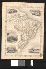
Русский: Данная карта Бразилии производства компании "Таллис" отличается ажурной рамкой и художественно выполненными картинами, изображенными на карте. Английская фирма "Джон Таллис и К" занималась выпуском карт в период с 1835 по 1869 гг. Карта была нарисована и выгравирована картографом Джоном Рэпкиным. Карты фирмы "Таллис" были известны своей точностью и использованием многочисленных географических названий и деталей. Их отличительной чертой было также ретуширование отдельных частей карты для обозначения топографических характеристик. Цветные иллюстрации, расположенные по углам карты, на которых изображены "Лодки на Рио-Негро" (в верхнем левом углу), "Святая Катарина" (в верхнем правом углу), "Монте-Видео" и "Мыс Святого Антония, Баия" (в нижнем левом углу) и "Рио-де-Жанейро" (в нижнем правом углу) демонтстрируют высокое качество карты и мастерство ее изготовителей.
Français : Cette carte du Brésil est une carte de Tallis, identifiable par les arabesques des bordures et les scènes délicatement dessinées inscrites sur la carte. John Tallis et Cie. était une entreprise de cartographie britannique entre environ 1835 et 1860. Cette carte fut dessinée et gravée par le cartographe John Rapkin. Les cartes de Tallis étaient réputées pour la précision de leurs dessins et les nombreux noms de lieux et détails géographiques, ainsi que pour l'usage de zones ombrées pour indiquer des caractéristiques topographiques. Le travail de grande qualité de la carte peut être observé dans les illustrations en couleur aux quatre coins représentant « Des bateaux sur le Rio Negro » (en haut à gauche), « Sainte Catherine » (en haut à droite), « Monte Video » et « Le cap Saint Antoine, Bahia » (en bas à gauche) et « Rio de Janeiro » (en bas à droite).
English: This map of Brazil is a Tallis map, identifiable by the scrolling on the borders and the finely-drawn scenes inscribed on the map. John Tallis and Co. was a British mapmaking firm that operated from roughly 1835 to 1860. The map was drawn and engraved by cartographer John Rapkin. Tallis maps were known for their accurate designs and numerous place names and geographical details, as well as for the use of shaded areas to indicate topographical features. The fine craftsmanship of the map can be seen in the color illustrations in the four corners showing “Boats on the Rio Negro” (upper left), “St. Catharina” (upper right), “Monte Video” and “Cape St. Antonio, Bahia” (lower left), and “Rio de Janeiro” (lower right).
中文:这幅巴西地图是一幅塔利斯地图,这一点可以从边界上的螺线和地图上精心绘制的场景来给以识别。 约翰·塔利斯公司是一家经营于约 1835 年至 1860 年期间的英国地图公司。 该地图是由制图师约翰·拉普金绘制和制版的。 塔利斯地图以其准确的设计和丰富地名以及地理细节而闻名,而且还是用阴影来显示地形特征。 可以从四角上的彩色图案中看出该幅地图优良的手工工艺,地图的四角分别注有“在里奥内格罗的船只”(左上角)、 “圣凯萨琳娜”(右上角)、“蒙得维的亚”和“圣安东尼奥角”(左下角)、 和“里约热内卢”(右下角)
Português: Este mapa do Brasil é um mapa Tallis, identificável pelo estilo pergaminho nas bordas e pelas cenas ricamente ilustradas nele inscritas. John Tallis e Cia. era uma empresa britânica de cartografia que funcionou entre cerca de 1835 a 1860. O mapa foi elaborado e gravado pelo cartógrafo John Rapkin. Os mapas Tallis eram conhecidos por seus desenhos precisos e numerosos topônimos e detalhes geográficos, bem como pela utilização de áreas sombreadas para indicar características topográficas. A beleza artesanal do mapa pode ser vista nas ilustrações coloridas dos quatro cantos que mostram "Barcos no Rio Negro" (canto superior esquerdo), "Santa Catarina" (canto superior direito),"Montevidéu" e "Cabo de Santo Antonio, Bahia" (abaixo, à esquerda), e "Rio de Janeiro" (abaixo, à direita).
العربية: هذه الخريطة من إنتاج تاليس، ومن الممكن تمييزها من اللفيفة على الحواشي والدقة في رسم المناظر المنقوشة على الخريطة.
كانت جون تاليس وشركاه شركة بريطانية لصنع الخرائط وقد عملت من حوالي 1835 إلى 1860. رسم هذه الخريطة ونقشها رسام الخرائط جون رابكن.
وكانت خرائط تاليس معروفة لدقة تصاميمها وكثرة أسماء الأماكن فيها وتفاصيلها الجغرافية، بالإضافة إلى استعمال الظلال للإشارة إلى الميزات الطوبوغرافية.
يمكن مشاهدة المهارة الرائعة في هذه الخريطة في الإيضاحات الملونة التي تظهر "زوارق على ريو نيغرو" (أعلى اليسار)، و"سانت
كاتارينا" (أعلى اليمين)، و"مونت فيديو" و"رأس سانت
أنطونيو، باهيا" (أسفل اليسار)، و"ريو دي جانيرو" (أسفل اليمين). Español: Este mapa de Brasil es un Tallis, identificable por los ornamentos de los bordes y las delicadas escenas inscritas en el mapa.
John Tallis and Co. fue una firma cartográfica británica que estuvo activa aproximadamente desde 1835 a 1860.
El mapa fue dibujado y grabado por el cartógrafo John Rapkin. Los mapas de Tallis eran famosos por sus diseños precisos y sus numerosos nombres y detalles geográficos, así como por el uso de áreas sombreadas para indicar lugares topográficos destacados. La artesanía elegante del mapa se puede apreciar en las ilustraciones en color de las cuatro esquinas que representan "Barcos en el Río Negro" (superior izquierda), "Santa
Catarina" (superior derecha), "Monte Video" y "Cabo San
Antonio, Bahia" (inferior izquierda) y "Río de Janeiro" (inferior derecha). |
| Date | 1851 |
| Medium |
Русский: Карты
Français : Cartes
English: Maps
中文:地图
Português: Mapas
العربية: خرائط
Español: Mapas |
| Dimensions |
English: 1 map : color ; 31 x 22 centimeters |
| Collection |
Русский: Национальная библиотека Бразилии
Français : Bibliothèque nationale du Brésil
English: National Library of Brazil
中文:巴西国家图书馆
Português: Biblioteca Nacional do Brasil
العربية: مكتبة البرازيل الوطنية
Español: Biblioteca Nacional de Brasil |
| Place of creation |
Русский: Бразилия
Français : Brésil
English: Brazil
中文:巴西
Português: Brasil
العربية: البرازيل
Español: Brasil |
| References | http://hdl.loc.gov/loc.wdl/brrjbn.48 |
| Source/Photographer |
|
Licensing
[edit]
|
This is a faithful photographic reproduction of a two-dimensional, public domain work of art. The work of art itself is in the public domain for the following reason:
The official position taken by the Wikimedia Foundation is that "faithful reproductions of two-dimensional public domain works of art are public domain".
This photographic reproduction is therefore also considered to be in the public domain in the United States. In other jurisdictions, re-use of this content may be restricted; see Reuse of PD-Art photographs for details. | ||||
File history
Click on a date/time to view the file as it appeared at that time.
| Date/Time | Thumbnail | Dimensions | User | Comment | |
|---|---|---|---|---|---|
| current | 18:32, 11 March 2014 | | 1,024 × 1,533 (2.94 MB) | Fæ (talk | contribs) | =={{int:filedesc}}== {{Artwork |artist = |author ={{ru|1=Рэпкин, Дж.}} {{fr|1=Rapkin, John, 1815-1876}} {{en|1=Rapkin, John, 1815-1876}} {{zh|1=瑞普金, J.}} {{pt|1=Rapkin, John, 1815-1876}} {{ar|1=رابكين, ج.}} {{es|1=Rapkin, John, 181... |
You cannot overwrite this file.
File usage on Commons
The following page uses this file: