File:Brayton Gates railway station (site), Yorkshire (geograph 6534767).jpg
Jump to navigation
Jump to search

Size of this preview: 800 × 600 pixels. Other resolutions: 320 × 240 pixels | 640 × 480 pixels | 1,024 × 768 pixels | 1,280 × 960 pixels | 1,600 × 1,200 pixels.
Original file (1,600 × 1,200 pixels, file size: 320 KB, MIME type: image/jpeg)
Captions
Captions
Add a one-line explanation of what this file represents
Summary
[edit],_Yorkshire_(geograph_6534767).jpg&action=edit§ion=1)
| Description |
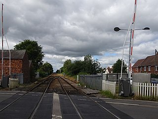
English: Brayton Gates railway station (site), Yorkshire Opened in 1898 as the Selby terminus of the Cawood, Wistow & Selby Light Railway, soon to become part of the North Eastern Railway, this station closed in 1904 when services were diverted into the NER station. View west towards Wistow and Cawood, which diverged here to the right. The short-lived terminus station was to the right of the railway line, between the signal and the white house centre-right of the image, hidden from view by vegetation. A small engine-shed was also located here. |
| Date | |
| Source | From geograph.org.uk |
| Author | Nigel Thompson |
| Permission (Reusing this file) |
Creative Commons Attribution Share-alike license 2.0 |
| Attribution (required by the license) | Nigel Thompson / Brayton Gates railway station (site), Yorkshire / |
| Camera location | | View this and other nearby images on: OpenStreetMap |
|---|
,_Yorkshire_(geograph_6534767).jpg¶ms=053.779512_N_-001.076546_E_globe:Earth_type:camera_source:geograph-osgb36(SE60953186)_heading:270.00&language=en)
| Object location | | View this and other nearby images on: OpenStreetMap |
|---|
,_Yorkshire_(geograph_6534767).jpg¶ms=053.779430_N_-001.077760_E_globe:Earth_class:object_type:object_source:geograph-osgb36(SE60873185)_heading:270.00&language=en)
Licensing
[edit],_Yorkshire_(geograph_6534767).jpg&action=edit§ion=2)

|
This image was taken from the Geograph project collection. See this photograph's page on the Geograph website for the photographer's contact details. The copyright on this image is owned by Nigel Thompson and is licensed for reuse under the Creative Commons Attribution-ShareAlike 2.0 license.
|
This file is licensed under the Creative Commons Attribution-Share Alike 2.0 Generic license.
Attribution: Nigel Thompson
- You are free:
- to share – to copy, distribute and transmit the work
- to remix – to adapt the work
- Under the following conditions:
- attribution – You must give appropriate credit, provide a link to the license, and indicate if changes were made. You may do so in any reasonable manner, but not in any way that suggests the licensor endorses you or your use.
- share alike – If you remix, transform, or build upon the material, you must distribute your contributions under the same or compatible license as the original.
File history
Click on a date/time to view the file as it appeared at that time.
| Date/Time | Thumbnail | Dimensions | User | Comment | |
|---|---|---|---|---|---|
| current | 09:46, 29 July 2020 | | 1,600 × 1,200 (320 KB) | Lamberhurst (talk | contribs) | Transferred from geograph.co.uk using [https://tools.wmflabs.org/geograph2commons/ geograph2commons] |
You cannot overwrite this file.
File usage on Commons
The following page uses this file:
File usage on other wikis
The following other wikis use this file:
- Usage on en.wikipedia.org
,_Yorkshire_(geograph_6534767).jpg&oldid=831877794)