File:Brauneberg-Fährhaus-2019(5).jpg
Jump to navigation
Jump to search

Size of this preview: 800 × 533 pixels. Other resolutions: 320 × 213 pixels | 640 × 427 pixels | 1,024 × 683 pixels | 1,280 × 853 pixels | 2,560 × 1,707 pixels | 3,648 × 2,432 pixels.
Original file (3,648 × 2,432 pixels, file size: 4.48 MB, MIME type: image/jpeg)
Captions
Captions
Add a one-line explanation of what this file represents
Summary
[edit].jpg&action=edit§ion=1)
| Description |
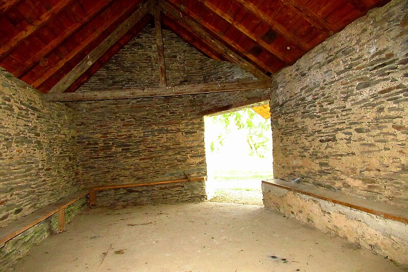
Deutsch: Brauneberger Fährhaus: Das kleine Gebäude steht am ehemaligen Fährkopf am linken Moselufer gegenüber dem Dorf Brauneberg. Es besteht aus fensterlosem, nur außen verputztem Schiefermauerwerk und hat einem einzigen hallenartigen Raum mit einer an den Innenwänden umlaufenden Sitzbank. Der mit seiner Hauptachse in etwa Ost-West-ausgerichtete Hallenbau schließt im Westen mit einer dreieckförmigen Apsis ab. Die Ecke im Südosten ist abgeschrägt, mit einer annähernd quadratischen Öffnung die den Eingang darstellt und die Sicht von Innen auf die vormalige Fährstrecke freigibt. Mutmaßlich bereits im 18. Jahrhundert erbaut, diente es Mensch und Vieh als Warte- und Schutzhäuschen an der Gemeindefähre. Nachdem am 31. Dezember 1970 der letzte Fährbetrieb eingestellt wurde, wurde das Gebäude lange vernachlässigt. Im Jahr 2010 wurde es gründlich saniert und dient seitdem wieder als Schutzhütte, diesmal für touristische Wanderer und Radfahrer.
English: Brauneberger Fährhaus: The small building stands at the former ferry head on the left bank of the Moselle opposite the village of Brauneberg. It consists of windowless slate masonry, plastered only on the outside, and has a single hall-like room with a bench seat running around the inside walls. The hall building with a nearly east-west oriented main axis ends in the west with a triangular apse. The corner in the south-east is chamfered, with an almost square opening that forms the entrance and provides a view of the former ferry route from the inside. Presumably built as early as the 18th century, it served as a waiting and shelter house for people and livestock at the comunity ferry. After the last ferry service was discontinued on December 31, 1970, the building was neglected for a long time. In 2010, it was thoroughly renovated and has since been used as a shelter again, this time for tourist hikers and cyclists. |
| Date | 26 August 2019 (according to Exif data) |
| Source | Own work |
| Author | Dkvtig |
| Permission (Reusing this file) |
I, the copyright holder of this work, hereby publish it under the following license: This file is licensed under the Creative Commons Attribution-Share Alike 4.0 International license.
|
| Object location | | View this and other nearby images on: OpenStreetMap |
|---|
.jpg¶ms=049.910778_N_0006.982139_E_globe:Earth_class:object_type:object_region:DE-RP_&language=en)
File history
Click on a date/time to view the file as it appeared at that time.
| Date/Time | Thumbnail | Dimensions | User | Comment | |
|---|---|---|---|---|---|
| current | 23:11, 20 January 2024 | | 3,648 × 2,432 (4.48 MB) | Dkvtig (talk | contribs) | {{Information |description = {{de|Brauneberger Fährhaus: Das kleine Gebäude steht am ehemaligen Fährkopf am linken Moselufer gegenüber dem Dorf Brauneberg. Es besteht aus fensterlosem, nur außen verputztem Schiefermauerwerk und hat einem einzigen hallenartigen Raum mit einer an den Innenwänden umlaufenden Sitzbank. Der mit seiner Hauptachse in etwa Ost-West-ausgerichtete Hallenbau schließt im Westen mit einer dreieckförmigen Apsis ab. Die Ecke im Südosten ist abgeschrägt, mit einer annäh... |
You cannot overwrite this file.
File usage on Commons
There are no pages that use this file.
.jpg&oldid=846285716)