File:Bratislava - Burg (c).JPG
Jump to navigation
Jump to search

Size of this preview: 800 × 450 pixels. Other resolutions: 320 × 180 pixels | 640 × 360 pixels | 1,024 × 576 pixels | 1,280 × 720 pixels | 2,560 × 1,440 pixels | 4,445 × 2,500 pixels.
Original file (4,445 × 2,500 pixels, file size: 9.45 MB, MIME type: image/jpeg)
Captions
Captions
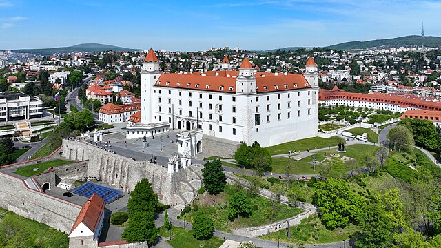
Southeast view of Bratislava Castle.
Summary
[edit]| Description |
Deutsch: Südostansicht der Burg in der slowakischen Hauptstadt Bratislava, ehemals Preßburg.
Die imposante Burg befindet sich auf einem rd. 85 Meter hohen Felsen über dem linken Ufer der Donau, der seit der Steinzeit besiedelt wird. Kaiserin Maria Theresia ließ die Burg großzügig in eine repräsentative Barockresidenz umbauenː [1]. Am 28. Mai 1811 brach ein drei Tage dauerndes Feuer aus und man verzichtete auf einen Wiederaufbau. Erst nach dem Zweiten Weltkrieg wurde sie von 1953 bis 1968 wiederinstandgesetzt und weitgehendst der Zustand zu Maria Theresias Zeiten hergestellt. English: Southeast view of Bratislava Castle. |
| Date | |
| Source | Own work |
| Author | C.Stadler/Bwag |
| Permission (Reusing this file) |
Deutsch: Hallo, du darfst mein Foto kostenlos nutzen, aber nenne mich bitte als Fotograf, beispielsweise „Foto: C.Stadler/Bwag“ oder © C.Stadler/Bwag; CC-BY-SA-4.0. Auf mehr Angaben bestehe ich nicht - im Gegensatz zu manch anderen, die die Vorgaben der unten angeführten Lizenzierung auf Punkt und Beistrich einfordern. English: Feel free to use my photos, but please mention me as the author like © C.Stadler/Bwag or © C.Stadler/Bwag; CC-BY-SA-4.0 (that's good enough) and if you want send me a message: bwag@gmx.net. |
| Other versions |
|
.JPG)
.JPG)
.JPG&action=edit§ion=1)
| Object location | | View this and other nearby images on: OpenStreetMap |
|---|
.JPG¶ms=048.142320_N_0017.100140_E_globe:Earth_class:object_type:object__&language=en)
| Camera location | | View this and other nearby images on: OpenStreetMap |
|---|
.JPG¶ms=048.140580_N_0017.101830_E_globe:Earth_type:camera_heading:330.00&language=en)
Licensing
[edit].JPG&action=edit§ion=2)
I, the copyright holder of this work, hereby publish it under the following license:
This file is licensed under the Creative Commons Attribution-Share Alike 4.0 International license.
- You are free:
- to share – to copy, distribute and transmit the work
- to remix – to adapt the work
- Under the following conditions:
- attribution – You must give appropriate credit, provide a link to the license, and indicate if changes were made. You may do so in any reasonable manner, but not in any way that suggests the licensor endorses you or your use.
- share alike – If you remix, transform, or build upon the material, you must distribute your contributions under the same or compatible license as the original.
File history
Click on a date/time to view the file as it appeared at that time.
| Date/Time | Thumbnail | Dimensions | User | Comment | |
|---|---|---|---|---|---|
| current | 19:27, 18 April 2024 | | 4,445 × 2,500 (9.45 MB) | Bwag (talk | contribs) | == {{int:filedesc}} == {{Information |Description= {{de|1= Südostansicht der Burg in der slowakischen Hauptstadt Bratislava, ehemals Preßburg.<br/>Die imposante Burg befindet sich auf einem rd. 85 Meter hohen Felsen über dem linken Ufer der Donau, der seit der Steinzeit besiedelt wird. Kaiserin Maria Theresia ließ die Burg großzügig in eine repräsentative Barockresidenz umbauenː [https://www.visitbratislava.com/de/setzt/burg-bratislava/]. Am 28. Mai 1811 brach ein drei Tage dauerndes Feuer a... |
You cannot overwrite this file.
File usage on Commons
The following 2 pages use this file:
File usage on other wikis
The following other wikis use this file:
- Usage on an.wikipedia.org
- Usage on de.wikipedia.org
- Usage on en.wikipedia.org
- Usage on hu.wikipedia.org
- Usage on ja.wikipedia.org
- Usage on ro.wikipedia.org
- Usage on sk.wikipedia.org
- Usage on sr.wikipedia.org
- Usage on tr.wikipedia.org
.JPG&oldid=894603289)