File:Bournemouth, Celtic Orthodox parish church of St. Joseph of Arimathea - geograph.org.uk - 1150939.jpg
Jump to navigation
Jump to search

Size of this preview: 450 × 600 pixels. Other resolutions: 180 × 240 pixels | 480 × 640 pixels.
Original file (480 × 640 pixels, file size: 85 KB, MIME type: image/jpeg)
Captions
Captions
Add a one-line explanation of what this file represents
Summary
[edit]
| Description |
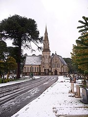
English: Celtic Orthodox parish church of St Joseph of Arimathea, Wimborne Road Cemetery, Bournemouth, seen from the south. The church was built as the cemetery's Church of England chapel. |
| Date | |
| Source | From geograph.org.uk |
| Author | Chris Downer |
| Attribution (required by the license) | Chris Downer / Bournemouth: Celtic Orthodox parish church of St. Joseph of Arimathea / |
| Camera location | | View this and other nearby images on: OpenStreetMap |
|---|
_heading:22.00&language=en)
| Object location | | View this and other nearby images on: OpenStreetMap |
|---|
_heading:22.00&language=en)
Licensing
[edit]

|
This image was taken from the Geograph project collection. See this photograph's page on the Geograph website for the photographer's contact details. The copyright on this image is owned by Chris Downer and is licensed for reuse under the Creative Commons Attribution-ShareAlike 2.0 license.
|
This file is licensed under the Creative Commons Attribution-Share Alike 2.0 Generic license.
Attribution: Chris Downer
- You are free:
- to share – to copy, distribute and transmit the work
- to remix – to adapt the work
- Under the following conditions:
- attribution – You must give appropriate credit, provide a link to the license, and indicate if changes were made. You may do so in any reasonable manner, but not in any way that suggests the licensor endorses you or your use.
- share alike – If you remix, transform, or build upon the material, you must distribute your contributions under the same or compatible license as the original.
File history
Click on a date/time to view the file as it appeared at that time.
| Date/Time | Thumbnail | Dimensions | User | Comment | |
|---|---|---|---|---|---|
| current | 09:46, 25 February 2011 | | 480 × 640 (85 KB) | GeographBot (talk | contribs) | == {{int:filedesc}} == {{Information |description={{en|1=Bournemouth: Celtic Orthodox parish church of St. Joseph of Arimathea This was originally the cemetery chapel of 1150935 (although it almost seems too substantial a building to be termed chapel |
You cannot overwrite this file.
File usage on Commons
There are no pages that use this file.
Metadata
Categories:
- 1870s church towers in England
- Broach spires in Dorset
- Church spires in Dorset
- Churches in Dorset in snow
- February 2009 in Bournemouth
- Gothic Revival church towers in Dorset
- Gothic Revival spires in Dorset
- Roads in Bournemouth
- Snow in Bournemouth
- Transepts in Dorset
- Trees in Dorset
- Wimborne Road Cemetery Anglican Chapel