File:Bourne End railway station 1861486 706a4360.jpg
Jump to navigation
Jump to search
No higher resolution available.
Bourne_End_railway_station_1861486_706a4360.jpg (640 × 337 pixels, file size: 106 KB, MIME type: image/jpeg)
Captions
Captions
Add a one-line explanation of what this file represents
Summary
[edit]
| Description |
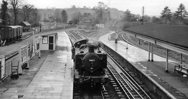
English: Bourne End Station. View SW, towards Marlow right, Maidenhead left; ex-GWR Maidenhead - High Wycombe line, junction of branch to Marlow. Line closed from High Wycombe 4/5/70, leaving Bourne End a terminus. (A 94XX 0-6-0 Pannier tank in foreground). |
| Date | Taken on 28 November 1959 |
| Source | From geograph.org.uk |
| Author | Ben Brooksbank |
| Permission (Reusing this file) |
Creative Commons Attribution Share-alike license 2.0 |
| Camera location | | View this and other nearby images on: OpenStreetMap |
|---|
Licensing
[edit]

|
This image was taken from the Geograph project collection. See this photograph's page on the Geograph website for the photographer's contact details. The copyright on this image is owned by Ben Brooksbank and is licensed for reuse under the Creative Commons Attribution-ShareAlike 2.0 license.
|
This file is licensed under the Creative Commons Attribution-Share Alike 2.0 Generic license.
Attribution: Ben Brooksbank
- You are free:
- to share – to copy, distribute and transmit the work
- to remix – to adapt the work
- Under the following conditions:
- attribution – You must give appropriate credit, provide a link to the license, and indicate if changes were made. You may do so in any reasonable manner, but not in any way that suggests the licensor endorses you or your use.
- share alike – If you remix, transform, or build upon the material, you must distribute your contributions under the same or compatible license as the original.
File history
Click on a date/time to view the file as it appeared at that time.
| Date/Time | Thumbnail | Dimensions | User | Comment | |
|---|---|---|---|---|---|
| current | 14:09, 11 November 2010 | | 640 × 337 (106 KB) | Chevin (talk | contribs) | == {{int:filedesc}} == {{Information |Description={{en|1=Bourne End Station View SW, towards Marlow right, Maidenhead left; ex-GWR Maidenhead - High Wycombe line, junction of branch to Marlow. Line closed from High Wycombe 4/5/70, leaving Bourne End a ter |
You cannot overwrite this file.
File usage on Commons
There are no pages that use this file.
File usage on other wikis
The following other wikis use this file:
- Usage on en.wikipedia.org